


To view satellite imagery and bounding box footprint of individual city/location maps, click below on specific links

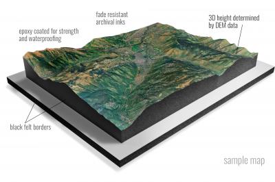
• Raised-relief 3D Height Determined by DEM data
• Fade Resistant Archival Inks
• Epoxy Coated for Strength and Waterproofing
• Ready to Hang with Pre-Installed Hardware (optional)
• Extraordinary 3D Accuracy
• Black Felt Borders
Enrich your office decor or home with a 3D Satellite Raised Relief Map. These raised relief maps are not flat. They are three-dimensional, with the height being determined by Digital Elevation Model (DEM) data. Many people struggle with reading 2D satellite maps, but everyone understands 3D raised relief maps. The realism is phenomenal.
This 3D satellite raised relief map is built by combining satellite imagery data from Google Earth, bounding box coordinates from USGS, and DEM data. 3D Printing and 3D CNC routers are used to fabricate the models which make the satellite models extremely accurate. These models are strong - they are coated with epoxy, then finished with a sealer providing a weatherproof matt-finish. These are not meant to be used in direct sunlight.
Abbey Hill, North Dakota- Map Components- Imagery: Satellite of Abbey Hill, North Dakota. Bounding Box: Footprint of Abbey Hill, North Dakota at Longitude/Latitude Coordinates (-102.625 x -102.5 x 46.375 x 46.25).
Abercrombie, North Dakota- Map Components- Imagery: Satellite of Abercrombie, North Dakota. Bounding Box: Footprint of Abercrombie, North Dakota at Longitude/Latitude Coordinates (-96.75 x -96.625 x 46.5 x 46.375).
Absaraka, North Dakota- Map Components- Imagery: Satellite of Absaraka, North Dakota. Bounding Box: Footprint of Absaraka, North Dakota at Longitude/Latitude Coordinates (-97.5 x -97.375 x 47 x 46.875).
Adams, North Dakota- Map Components- Imagery: Satellite of Adams, North Dakota. Bounding Box: Footprint of Adams, North Dakota at Longitude/Latitude Coordinates (-98.125 x -98 x 48.5 x 48.375).
Adams SE, North Dakota- Map Components- Imagery: Satellite of Adams SE, North Dakota. Bounding Box: Footprint of Adams SE, North Dakota at Longitude/Latitude Coordinates (-98.125 x -98 x 48.375 x 48.25).
Adams SW, North Dakota- Map Components- Imagery: Satellite of Adams SW, North Dakota. Bounding Box: Footprint of Adams SW, North Dakota at Longitude/Latitude Coordinates (-98.25 x -98.125 x 48.375 x 48.25).
Adrian, North Dakota- Map Components- Imagery: Satellite of Adrian, North Dakota. Bounding Box: Footprint of Adrian, North Dakota at Longitude/Latitude Coordinates (-98.625 x -98.5 x 46.625 x 46.5).
Alamo, North Dakota- Map Components- Imagery: Satellite of Alamo, North Dakota. Bounding Box: Footprint of Alamo, North Dakota at Longitude/Latitude Coordinates (-103.5 x -103.375 x 48.625 x 48.5).
Alamo NE, North Dakota- Map Components- Imagery: Satellite of Alamo NE, North Dakota. Bounding Box: Footprint of Alamo NE, North Dakota at Longitude/Latitude Coordinates (-103.375 x -103.25 x 48.75 x 48.625).
Alexander, North Dakota- Map Components- Imagery: Satellite of Alexander, North Dakota. Bounding Box: Footprint of Alexander, North Dakota at Longitude/Latitude Coordinates (-103.75 x -103.625 x 47.875 x 47.75).
Alexandria, North Dakota- Map Components- Imagery: Satellite of Alexandria, North Dakota. Bounding Box: Footprint of Alexandria, North Dakota at Longitude/Latitude Coordinates (-103.75 x -103.625 x 48.875 x 48.75).
Alfred, North Dakota- Map Components- Imagery: Satellite of Alfred, North Dakota. Bounding Box: Footprint of Alfred, North Dakota at Longitude/Latitude Coordinates (-99.125 x -99 x 46.625 x 46.5).
Alice, North Dakota- Map Components- Imagery: Satellite of Alice, North Dakota. Bounding Box: Footprint of Alice, North Dakota at Longitude/Latitude Coordinates (-97.625 x -97.5 x 46.875 x 46.75).
Alkabo, North Dakota- Map Components- Imagery: Satellite of Alkabo, North Dakota. Bounding Box: Footprint of Alkabo, North Dakota at Longitude/Latitude Coordinates (-104 x -103.875 x 48.875 x 48.75).
Alkali Lake, North Dakota- Map Components- Imagery: Satellite of Alkali Lake, North Dakota. Bounding Box: Footprint of Alkali Lake, North Dakota at Longitude/Latitude Coordinates (-100.75 x -100.625 x 47.75 x 47.625).
Alkaline Lake, North Dakota- Map Components- Imagery: Satellite of Alkaline Lake, North Dakota. Bounding Box: Footprint of Alkaline Lake, North Dakota at Longitude/Latitude Coordinates (-99.625 x -99.5 x 46.75 x 46.625).
Alkaline Lake NW, North Dakota- Map Components- Imagery: Satellite of Alkaline Lake NW, North Dakota. Bounding Box: Footprint of Alkaline Lake NW, North Dakota at Longitude/Latitude Coordinates (-99.75 x -99.625 x 46.75 x 46.625).
Alkaline Lake SW, North Dakota- Map Components- Imagery: Satellite of Alkaline Lake SW, North Dakota. Bounding Box: Footprint of Alkaline Lake SW, North Dakota at Longitude/Latitude Coordinates (-99.75 x -99.625 x 46.625 x 46.5).
Almont East, North Dakota- Map Components- Imagery: Satellite of Almont East, North Dakota. Bounding Box: Footprint of Almont East, North Dakota at Longitude/Latitude Coordinates (-101.5 x -101.375 x 46.75 x 46.625).
Almont West, North Dakota- Map Components- Imagery: Satellite of Almont West, North Dakota. Bounding Box: Footprint of Almont West, North Dakota at Longitude/Latitude Coordinates (-101.625 x -101.5 x 46.75 x 46.625).
Alpha, North Dakota- Map Components- Imagery: Satellite of Alpha, North Dakota. Bounding Box: Footprint of Alpha, North Dakota at Longitude/Latitude Coordinates (-103.875 x -103.75 x 46.75 x 46.625).
Alsen, North Dakota- Map Components- Imagery: Satellite of Alsen, North Dakota. Bounding Box: Footprint of Alsen, North Dakota at Longitude/Latitude Coordinates (-98.75 x -98.625 x 48.75 x 48.625).
Alsen SE, North Dakota- Map Components- Imagery: Satellite of Alsen SE, North Dakota. Bounding Box: Footprint of Alsen SE, North Dakota at Longitude/Latitude Coordinates (-98.625 x -98.5 x 48.625 x 48.5).
Ambrose, North Dakota- Map Components- Imagery: Satellite of Ambrose, North Dakota. Bounding Box: Footprint of Ambrose, North Dakota at Longitude/Latitude Coordinates (-103.5 x -103.375 x 49 x 48.875).
Amidon, North Dakota- Map Components- Imagery: Satellite of Amidon, North Dakota. Bounding Box: Footprint of Amidon, North Dakota at Longitude/Latitude Coordinates (-103.375 x -103.25 x 46.5 x 46.375).
Amidon SE, North Dakota- Map Components- Imagery: Satellite of Amidon SE, North Dakota. Bounding Box: Footprint of Amidon SE, North Dakota at Longitude/Latitude Coordinates (-103.375 x -103.25 x 46.375 x 46.25).
Anamoose, North Dakota- Map Components- Imagery: Satellite of Anamoose, North Dakota. Bounding Box: Footprint of Anamoose, North Dakota at Longitude/Latitude Coordinates (-100.25 x -100.125 x 48 x 47.875).
Anamoose SW, North Dakota- Map Components- Imagery: Satellite of Anamoose SW, North Dakota. Bounding Box: Footprint of Anamoose SW, North Dakota at Longitude/Latitude Coordinates (-100.25 x -100.125 x 47.875 x 47.75).
Aneta, North Dakota- Map Components- Imagery: Satellite of Aneta, North Dakota. Bounding Box: Footprint of Aneta, North Dakota at Longitude/Latitude Coordinates (-98 x -97.875 x 47.75 x 47.625).
Antelope, North Dakota- Map Components- Imagery: Satellite of Antelope, North Dakota. Bounding Box: Footprint of Antelope, North Dakota at Longitude/Latitude Coordinates (-102.25 x -102.125 x 46.875 x 46.75).
Antler, North Dakota- Map Components- Imagery: Satellite of Antler, North Dakota. Bounding Box: Footprint of Antler, North Dakota at Longitude/Latitude Coordinates (-101.375 x -101.25 x 49 x 48.875).
Antler NW, North Dakota- Map Components- Imagery: Satellite of Antler NW, North Dakota. Bounding Box: Footprint of Antler NW, North Dakota at Longitude/Latitude Coordinates (-101.5 x -101.375 x 49 x 48.875).
Antler SW, North Dakota- Map Components- Imagery: Satellite of Antler SW, North Dakota. Bounding Box: Footprint of Antler SW, North Dakota at Longitude/Latitude Coordinates (-101.5 x -101.375 x 48.875 x 48.75).
Appam, North Dakota- Map Components- Imagery: Satellite of Appam, North Dakota. Bounding Box: Footprint of Appam, North Dakota at Longitude/Latitude Coordinates (-103.625 x -103.5 x 48.625 x 48.5).
Appert Lake, North Dakota- Map Components- Imagery: Satellite of Appert Lake, North Dakota. Bounding Box: Footprint of Appert Lake, North Dakota at Longitude/Latitude Coordinates (-100.25 x -100.125 x 46.5 x 46.375).
Ardoch, North Dakota- Map Components- Imagery: Satellite of Ardoch, North Dakota. Bounding Box: Footprint of Ardoch, North Dakota at Longitude/Latitude Coordinates (-97.375 x -97.25 x 48.25 x 48.125).
Arena, North Dakota- Map Components- Imagery: Satellite of Arena, North Dakota. Bounding Box: Footprint of Arena, North Dakota at Longitude/Latitude Coordinates (-100.25 x -100.125 x 47.25 x 47.125).
Argusville, North Dakota- Map Components- Imagery: Satellite of Argusville, North Dakota. Bounding Box: Footprint of Argusville, North Dakota at Longitude/Latitude Coordinates (-97 x -96.875 x 47.125 x 47).
Arnegard, North Dakota- Map Components- Imagery: Satellite of Arnegard, North Dakota. Bounding Box: Footprint of Arnegard, North Dakota at Longitude/Latitude Coordinates (-103.5 x -103.375 x 47.875 x 47.75).
Arrowwood Lake, North Dakota- Map Components- Imagery: Satellite of Arrowwood Lake, North Dakota. Bounding Box: Footprint of Arrowwood Lake, North Dakota at Longitude/Latitude Coordinates (-98.875 x -98.75 x 47.375 x 47.25).
Arthur, North Dakota- Map Components- Imagery: Satellite of Arthur, North Dakota. Bounding Box: Footprint of Arthur, North Dakota at Longitude/Latitude Coordinates (-97.25 x -97.125 x 47.125 x 47).
Arthur SE, North Dakota- Map Components- Imagery: Satellite of Arthur SE, North Dakota. Bounding Box: Footprint of Arthur SE, North Dakota at Longitude/Latitude Coordinates (-97.125 x -97 x 47.125 x 47).
Arvilla, North Dakota- Map Components- Imagery: Satellite of Arvilla, North Dakota. Bounding Box: Footprint of Arvilla, North Dakota at Longitude/Latitude Coordinates (-97.5 x -97.375 x 48 x 47.875).
Ashley East, North Dakota- Map Components- Imagery: Satellite of Ashley East, North Dakota. Bounding Box: Footprint of Ashley East, North Dakota at Longitude/Latitude Coordinates (-99.375 x -99.25 x 46.125 x 46).
Ashley NE, North Dakota- Map Components- Imagery: Satellite of Ashley NE, North Dakota. Bounding Box: Footprint of Ashley NE, North Dakota at Longitude/Latitude Coordinates (-99.375 x -99.25 x 46.25 x 46.125).
Ashley West, North Dakota- Map Components- Imagery: Satellite of Ashley West, North Dakota. Bounding Box: Footprint of Ashley West, North Dakota at Longitude/Latitude Coordinates (-99.5 x -99.375 x 46.125 x 46).
Atcoal, North Dakota- Map Components- Imagery: Satellite of Atcoal, North Dakota. Bounding Box: Footprint of Atcoal, North Dakota at Longitude/Latitude Coordinates (-103 x -102.875 x 49 x 48.875).
Aurelia, North Dakota- Map Components- Imagery: Satellite of Aurelia, North Dakota. Bounding Box: Footprint of Aurelia, North Dakota at Longitude/Latitude Coordinates (-102 x -101.875 x 48.5 x 48.375).
Ayr, North Dakota- Map Components- Imagery: Satellite of Ayr, North Dakota. Bounding Box: Footprint of Ayr, North Dakota at Longitude/Latitude Coordinates (-97.5 x -97.375 x 47.125 x 47).
Ayr NE, North Dakota- Map Components- Imagery: Satellite of Ayr NE, North Dakota. Bounding Box: Footprint of Ayr NE, North Dakota at Longitude/Latitude Coordinates (-97.375 x -97.25 x 47.25 x 47.125).
Ayr NW, North Dakota- Map Components- Imagery: Satellite of Ayr NW, North Dakota. Bounding Box: Footprint of Ayr NW, North Dakota at Longitude/Latitude Coordinates (-97.5 x -97.375 x 47.25 x 47.125).
Ayr SE, North Dakota- Map Components- Imagery: Satellite of Ayr SE, North Dakota. Bounding Box: Footprint of Ayr SE, North Dakota at Longitude/Latitude Coordinates (-97.375 x -97.25 x 47.125 x 47).
Backoo, North Dakota- Map Components- Imagery: Satellite of Backoo, North Dakota. Bounding Box: Footprint of Backoo, North Dakota at Longitude/Latitude Coordinates (-97.75 x -97.625 x 48.875 x 48.75).
Baker, North Dakota- Map Components- Imagery: Satellite of Baker, North Dakota. Bounding Box: Footprint of Baker, North Dakota at Longitude/Latitude Coordinates (-99.75 x -99.625 x 48.25 x 48.125).
Baldhill Dam, North Dakota- Map Components- Imagery: Satellite of Baldhill Dam, North Dakota. Bounding Box: Footprint of Baldhill Dam, North Dakota at Longitude/Latitude Coordinates (-98.125 x -98 x 47.125 x 47).
Baldwin, North Dakota- Map Components- Imagery: Satellite of Baldwin, North Dakota. Bounding Box: Footprint of Baldwin, North Dakota at Longitude/Latitude Coordinates (-100.75 x -100.625 x 47.125 x 47).
Balfour, North Dakota- Map Components- Imagery: Satellite of Balfour, North Dakota. Bounding Box: Footprint of Balfour, North Dakota at Longitude/Latitude Coordinates (-100.625 x -100.5 x 48 x 47.875).
Balfour NW, North Dakota- Map Components- Imagery: Satellite of Balfour NW, North Dakota. Bounding Box: Footprint of Balfour NW, North Dakota at Longitude/Latitude Coordinates (-100.75 x -100.625 x 48 x 47.875).
Balta, North Dakota- Map Components- Imagery: Satellite of Balta, North Dakota. Bounding Box: Footprint of Balta, North Dakota at Longitude/Latitude Coordinates (-100.125 x -100 x 48.25 x 48.125).
Balta NW, North Dakota- Map Components- Imagery: Satellite of Balta NW, North Dakota. Bounding Box: Footprint of Balta NW, North Dakota at Longitude/Latitude Coordinates (-100.25 x -100.125 x 48.25 x 48.125).
Balta SE, North Dakota- Map Components- Imagery: Satellite of Balta SE, North Dakota. Bounding Box: Footprint of Balta SE, North Dakota at Longitude/Latitude Coordinates (-100.125 x -100 x 48.125 x 48).
Banks, North Dakota- Map Components- Imagery: Satellite of Banks, North Dakota. Bounding Box: Footprint of Banks, North Dakota at Longitude/Latitude Coordinates (-103.25 x -103.125 x 48.125 x 48).
Bantry, North Dakota- Map Components- Imagery: Satellite of Bantry, North Dakota. Bounding Box: Footprint of Bantry, North Dakota at Longitude/Latitude Coordinates (-100.625 x -100.5 x 48.5 x 48.375).
Bantry NW, North Dakota- Map Components- Imagery: Satellite of Bantry NW, North Dakota. Bounding Box: Footprint of Bantry NW, North Dakota at Longitude/Latitude Coordinates (-100.75 x -100.625 x 48.5 x 48.375).
Barlow, North Dakota- Map Components- Imagery: Satellite of Barlow, North Dakota. Bounding Box: Footprint of Barlow, North Dakota at Longitude/Latitude Coordinates (-99.25 x -99.125 x 47.625 x 47.5).
Barren Butte, North Dakota- Map Components- Imagery: Satellite of Barren Butte, North Dakota. Bounding Box: Footprint of Barren Butte, North Dakota at Longitude/Latitude Coordinates (-100.875 x -100.75 x 46.25 x 46.125).
Barrie, North Dakota- Map Components- Imagery: Satellite of Barrie, North Dakota. Bounding Box: Footprint of Barrie, North Dakota at Longitude/Latitude Coordinates (-97.125 x -97 x 46.625 x 46.5).
Barths Butte, North Dakota- Map Components- Imagery: Satellite of Barths Butte, North Dakota. Bounding Box: Footprint of Barths Butte, North Dakota at Longitude/Latitude Coordinates (-102.375 x -102.25 x 46.125 x 46).
Bartlett, North Dakota- Map Components- Imagery: Satellite of Bartlett, North Dakota. Bounding Box: Footprint of Bartlett, North Dakota at Longitude/Latitude Coordinates (-98.5 x -98.375 x 48.125 x 48).
Barton, North Dakota- Map Components- Imagery: Satellite of Barton, North Dakota. Bounding Box: Footprint of Barton, North Dakota at Longitude/Latitude Coordinates (-100.25 x -100.125 x 48.625 x 48.5).
Bathgate, North Dakota- Map Components- Imagery: Satellite of Bathgate, North Dakota. Bounding Box: Footprint of Bathgate, North Dakota at Longitude/Latitude Coordinates (-97.5 x -97.375 x 49 x 48.875).
Bathgate NE, North Dakota- Map Components- Imagery: Satellite of Bathgate NE, North Dakota. Bounding Box: Footprint of Bathgate NE, North Dakota at Longitude/Latitude Coordinates (-97.375 x -97.25 x 49 x 48.875).
Bathgate NE OE N, North Dakota- Map Components- Imagery: Satellite of Bathgate NE OE N, North Dakota. Bounding Box: Footprint of Bathgate NE OE N, North Dakota at Longitude/Latitude Coordinates (-97.375 x -97.25 x 49.125 x 49).
Bathgate OE N, North Dakota- Map Components- Imagery: Satellite of Bathgate OE N, North Dakota. Bounding Box: Footprint of Bathgate OE N, North Dakota at Longitude/Latitude Coordinates (-97.5 x -97.375 x 49.125 x 49).
Bathgate SE, North Dakota- Map Components- Imagery: Satellite of Bathgate SE, North Dakota. Bounding Box: Footprint of Bathgate SE, North Dakota at Longitude/Latitude Coordinates (-97.375 x -97.25 x 48.875 x 48.75).
Battleview, North Dakota- Map Components- Imagery: Satellite of Battleview, North Dakota. Bounding Box: Footprint of Battleview, North Dakota at Longitude/Latitude Coordinates (-102.875 x -102.75 x 48.625 x 48.5).
Beach East, North Dakota- Map Components- Imagery: Satellite of Beach East, North Dakota. Bounding Box: Footprint of Beach East, North Dakota at Longitude/Latitude Coordinates (-104 x -103.875 x 47 x 46.875).
Beach West, North Dakota- Map Components- Imagery: Satellite of Beach West, North Dakota. Bounding Box: Footprint of Beach West, North Dakota at Longitude/Latitude Coordinates (-104.125 x -104 x 47 x 46.875).
Bear Butte, North Dakota- Map Components- Imagery: Satellite of Bear Butte, North Dakota. Bounding Box: Footprint of Bear Butte, North Dakota at Longitude/Latitude Coordinates (-103.625 x -103.5 x 47.75 x 47.625).
Beaver Lake, North Dakota- Map Components- Imagery: Satellite of Beaver Lake, North Dakota. Bounding Box: Footprint of Beaver Lake, North Dakota at Longitude/Latitude Coordinates (-102.75 x -102.625 x 48.875 x 48.75).
Belcourt, North Dakota- Map Components- Imagery: Satellite of Belcourt, North Dakota. Bounding Box: Footprint of Belcourt, North Dakota at Longitude/Latitude Coordinates (-99.75 x -99.625 x 48.875 x 48.75).
Belden, North Dakota- Map Components- Imagery: Satellite of Belden, North Dakota. Bounding Box: Footprint of Belden, North Dakota at Longitude/Latitude Coordinates (-102.375 x -102.25 x 48.25 x 48.125).
Belden SE, North Dakota- Map Components- Imagery: Satellite of Belden SE, North Dakota. Bounding Box: Footprint of Belden SE, North Dakota at Longitude/Latitude Coordinates (-102.375 x -102.25 x 48.125 x 48).
Belden SW, North Dakota- Map Components- Imagery: Satellite of Belden SW, North Dakota. Bounding Box: Footprint of Belden SW, North Dakota at Longitude/Latitude Coordinates (-102.5 x -102.375 x 48.125 x 48).
Belfield, North Dakota- Map Components- Imagery: Satellite of Belfield, North Dakota. Bounding Box: Footprint of Belfield, North Dakota at Longitude/Latitude Coordinates (-103.25 x -103.125 x 47 x 46.875).
Belfield NE, North Dakota- Map Components- Imagery: Satellite of Belfield NE, North Dakota. Bounding Box: Footprint of Belfield NE, North Dakota at Longitude/Latitude Coordinates (-103.125 x -103 x 47 x 46.875).
Belfield SE, North Dakota- Map Components- Imagery: Satellite of Belfield SE, North Dakota. Bounding Box: Footprint of Belfield SE, North Dakota at Longitude/Latitude Coordinates (-103.125 x -103 x 46.875 x 46.75).
Belfield SW, North Dakota- Map Components- Imagery: Satellite of Belfield SW, North Dakota. Bounding Box: Footprint of Belfield SW, North Dakota at Longitude/Latitude Coordinates (-103.25 x -103.125 x 46.875 x 46.75).
Bell Coulee East, North Dakota- Map Components- Imagery: Satellite of Bell Coulee East, North Dakota. Bounding Box: Footprint of Bell Coulee East, North Dakota at Longitude/Latitude Coordinates (-101.375 x -101.25 x 46.25 x 46.125).
Bell Coulee West, North Dakota- Map Components- Imagery: Satellite of Bell Coulee West, North Dakota. Bounding Box: Footprint of Bell Coulee West, North Dakota at Longitude/Latitude Coordinates (-101.5 x -101.375 x 46.25 x 46.125).
Benedict, North Dakota- Map Components- Imagery: Satellite of Benedict, North Dakota. Bounding Box: Footprint of Benedict, North Dakota at Longitude/Latitude Coordinates (-101.125 x -101 x 47.875 x 47.75).
Benedict NW, North Dakota- Map Components- Imagery: Satellite of Benedict NW, North Dakota. Bounding Box: Footprint of Benedict NW, North Dakota at Longitude/Latitude Coordinates (-101.25 x -101.125 x 48 x 47.875).
Benedict SW, North Dakota- Map Components- Imagery: Satellite of Benedict SW, North Dakota. Bounding Box: Footprint of Benedict SW, North Dakota at Longitude/Latitude Coordinates (-101.25 x -101.125 x 47.875 x 47.75).
Bentley, North Dakota- Map Components- Imagery: Satellite of Bentley, North Dakota. Bounding Box: Footprint of Bentley, North Dakota at Longitude/Latitude Coordinates (-102.125 x -102 x 46.375 x 46.25).
Bergen, North Dakota- Map Components- Imagery: Satellite of Bergen, North Dakota. Bounding Box: Footprint of Bergen, North Dakota at Longitude/Latitude Coordinates (-100.75 x -100.625 x 48.125 x 48).
Berlin, North Dakota- Map Components- Imagery: Satellite of Berlin, North Dakota. Bounding Box: Footprint of Berlin, North Dakota at Longitude/Latitude Coordinates (-98.5 x -98.375 x 46.5 x 46.375).
Berthold, North Dakota- Map Components- Imagery: Satellite of Berthold, North Dakota. Bounding Box: Footprint of Berthold, North Dakota at Longitude/Latitude Coordinates (-101.75 x -101.625 x 48.375 x 48.25).
Berwick, North Dakota- Map Components- Imagery: Satellite of Berwick, North Dakota. Bounding Box: Footprint of Berwick, North Dakota at Longitude/Latitude Coordinates (-100.25 x -100.125 x 48.375 x 48.25).
Beulah, North Dakota- Map Components- Imagery: Satellite of Beulah, North Dakota. Bounding Box: Footprint of Beulah, North Dakota at Longitude/Latitude Coordinates (-101.875 x -101.75 x 47.375 x 47.25).
Beulah NE, North Dakota- Map Components- Imagery: Satellite of Beulah NE, North Dakota. Bounding Box: Footprint of Beulah NE, North Dakota at Longitude/Latitude Coordinates (-101.875 x -101.75 x 47.5 x 47.375).
Beulah NW, North Dakota- Map Components- Imagery: Satellite of Beulah NW, North Dakota. Bounding Box: Footprint of Beulah NW, North Dakota at Longitude/Latitude Coordinates (-102 x -101.875 x 47.5 x 47.375).
Big Coulee Dam, North Dakota- Map Components- Imagery: Satellite of Big Coulee Dam, North Dakota. Bounding Box: Footprint of Big Coulee Dam, North Dakota at Longitude/Latitude Coordinates (-99.375 x -99.25 x 48.75 x 48.625).
Big Meadow, North Dakota- Map Components- Imagery: Satellite of Big Meadow, North Dakota. Bounding Box: Footprint of Big Meadow, North Dakota at Longitude/Latitude Coordinates (-103.125 x -103 x 48.625 x 48.5).
Big Woods NW, North Dakota- Map Components- Imagery: Satellite of Big Woods NW, North Dakota. Bounding Box: Footprint of Big Woods NW, North Dakota at Longitude/Latitude Coordinates (-97.25 x -97.125 x 48.5 x 48.375).
Big Woods SW, North Dakota- Map Components- Imagery: Satellite of Big Woods SW, North Dakota. Bounding Box: Footprint of Big Woods SW, North Dakota at Longitude/Latitude Coordinates (-97.25 x -97.125 x 48.375 x 48.25).
Billings Lake, North Dakota- Map Components- Imagery: Satellite of Billings Lake, North Dakota. Bounding Box: Footprint of Billings Lake, North Dakota at Longitude/Latitude Coordinates (-98.5 x -98.375 x 48.625 x 48.5).
Binford, North Dakota- Map Components- Imagery: Satellite of Binford, North Dakota. Bounding Box: Footprint of Binford, North Dakota at Longitude/Latitude Coordinates (-98.375 x -98.25 x 47.625 x 47.5).
Binford NE, North Dakota- Map Components- Imagery: Satellite of Binford NE, North Dakota. Bounding Box: Footprint of Binford NE, North Dakota at Longitude/Latitude Coordinates (-98.375 x -98.25 x 47.75 x 47.625).
Binford NW, North Dakota- Map Components- Imagery: Satellite of Binford NW, North Dakota. Bounding Box: Footprint of Binford NW, North Dakota at Longitude/Latitude Coordinates (-98.5 x -98.375 x 47.75 x 47.625).
Bisbee North, North Dakota- Map Components- Imagery: Satellite of Bisbee North, North Dakota. Bounding Box: Footprint of Bisbee North, North Dakota at Longitude/Latitude Coordinates (-99.5 x -99.375 x 48.75 x 48.625).
Bisbee South, North Dakota- Map Components- Imagery: Satellite of Bisbee South, North Dakota. Bounding Box: Footprint of Bisbee South, North Dakota at Longitude/Latitude Coordinates (-99.5 x -99.375 x 48.625 x 48.5).
Bismarck, North Dakota- Map Components- Imagery: Satellite of Bismarck, North Dakota. Bounding Box: Footprint of Bismarck, North Dakota at Longitude/Latitude Coordinates (-100.875 x -100.75 x 46.875 x 46.75).
Bitter Lake, North Dakota- Map Components- Imagery: Satellite of Bitter Lake, North Dakota. Bounding Box: Footprint of Bitter Lake, North Dakota at Longitude/Latitude Coordinates (-98.25 x -98.125 x 48 x 47.875).
Blabon, North Dakota- Map Components- Imagery: Satellite of Blabon, North Dakota. Bounding Box: Footprint of Blabon, North Dakota at Longitude/Latitude Coordinates (-97.875 x -97.75 x 47.5 x 47.375).
Black Butte, North Dakota- Map Components- Imagery: Satellite of Black Butte, North Dakota. Bounding Box: Footprint of Black Butte, North Dakota at Longitude/Latitude Coordinates (-103.5 x -103.375 x 46.5 x 46.375).
Black Hammer Hill, North Dakota- Map Components- Imagery: Satellite of Black Hammer Hill, North Dakota. Bounding Box: Footprint of Black Hammer Hill, North Dakota at Longitude/Latitude Coordinates (-99.5 x -99.375 x 47.875 x 47.75).
Blacktail Coulee, North Dakota- Map Components- Imagery: Satellite of Blacktail Coulee, North Dakota. Bounding Box: Footprint of Blacktail Coulee, North Dakota at Longitude/Latitude Coordinates (-101 x -100.875 x 48 x 47.875).
Blacktail Lake, North Dakota- Map Components- Imagery: Satellite of Blacktail Lake, North Dakota. Bounding Box: Footprint of Blacktail Lake, North Dakota at Longitude/Latitude Coordinates (-103.75 x -103.625 x 48.5 x 48.375).
Blacktail Lake SE, North Dakota- Map Components- Imagery: Satellite of Blacktail Lake SE, North Dakota. Bounding Box: Footprint of Blacktail Lake SE, North Dakota at Longitude/Latitude Coordinates (-103.625 x -103.5 x 48.375 x 48.25).
Blackwater Lake, North Dakota- Map Components- Imagery: Satellite of Blackwater Lake, North Dakota. Bounding Box: Footprint of Blackwater Lake, North Dakota at Longitude/Latitude Coordinates (-101.875 x -101.75 x 47.75 x 47.625).
Blackwater Lake NW, North Dakota- Map Components- Imagery: Satellite of Blackwater Lake NW, North Dakota. Bounding Box: Footprint of Blackwater Lake NW, North Dakota at Longitude/Latitude Coordinates (-102 x -101.875 x 47.75 x 47.625).
Blackwater Lake SE, North Dakota- Map Components- Imagery: Satellite of Blackwater Lake SE, North Dakota. Bounding Box: Footprint of Blackwater Lake SE, North Dakota at Longitude/Latitude Coordinates (-101.875 x -101.75 x 47.625 x 47.5).
Blackwater Lake SW, North Dakota- Map Components- Imagery: Satellite of Blackwater Lake SW, North Dakota. Bounding Box: Footprint of Blackwater Lake SW, North Dakota at Longitude/Latitude Coordinates (-102 x -101.875 x 47.625 x 47.5).
Blaisdell, North Dakota- Map Components- Imagery: Satellite of Blaisdell, North Dakota. Bounding Box: Footprint of Blaisdell, North Dakota at Longitude/Latitude Coordinates (-102.125 x -102 x 48.375 x 48.25).
Blanchard, North Dakota- Map Components- Imagery: Satellite of Blanchard, North Dakota. Bounding Box: Footprint of Blanchard, North Dakota at Longitude/Latitude Coordinates (-97.25 x -97.125 x 47.375 x 47.25).
Bloom, North Dakota- Map Components- Imagery: Satellite of Bloom, North Dakota. Bounding Box: Footprint of Bloom, North Dakota at Longitude/Latitude Coordinates (-98.625 x -98.5 x 47 x 46.875).
Blue Buttes, North Dakota- Map Components- Imagery: Satellite of Blue Buttes, North Dakota. Bounding Box: Footprint of Blue Buttes, North Dakota at Longitude/Latitude Coordinates (-102.875 x -102.75 x 48 x 47.875).
Blue Buttes SE, North Dakota- Map Components- Imagery: Satellite of Blue Buttes SE, North Dakota. Bounding Box: Footprint of Blue Buttes SE, North Dakota at Longitude/Latitude Coordinates (-102.875 x -102.75 x 47.875 x 47.75).
Blue Hill, North Dakota- Map Components- Imagery: Satellite of Blue Hill, North Dakota. Bounding Box: Footprint of Blue Hill, North Dakota at Longitude/Latitude Coordinates (-101.75 x -101.625 x 47.875 x 47.75).
Bluegrass, North Dakota- Map Components- Imagery: Satellite of Bluegrass, North Dakota. Bounding Box: Footprint of Bluegrass, North Dakota at Longitude/Latitude Coordinates (-101.625 x -101.5 x 47 x 46.875).
Bonetraill, North Dakota- Map Components- Imagery: Satellite of Bonetraill, North Dakota. Bounding Box: Footprint of Bonetraill, North Dakota at Longitude/Latitude Coordinates (-103.875 x -103.75 x 48.5 x 48.375).
Bonetraill SE, North Dakota- Map Components- Imagery: Satellite of Bonetraill SE, North Dakota. Bounding Box: Footprint of Bonetraill SE, North Dakota at Longitude/Latitude Coordinates (-103.875 x -103.75 x 48.375 x 48.25).
Bonetraill SW, North Dakota- Map Components- Imagery: Satellite of Bonetraill SW, North Dakota. Bounding Box: Footprint of Bonetraill SW, North Dakota at Longitude/Latitude Coordinates (-104 x -103.875 x 48.375 x 48.25).
Bordulac, North Dakota- Map Components- Imagery: Satellite of Bordulac, North Dakota. Bounding Box: Footprint of Bordulac, North Dakota at Longitude/Latitude Coordinates (-99 x -98.875 x 47.5 x 47.375).
Bordulac NE, North Dakota- Map Components- Imagery: Satellite of Bordulac NE, North Dakota. Bounding Box: Footprint of Bordulac NE, North Dakota at Longitude/Latitude Coordinates (-98.875 x -98.75 x 47.5 x 47.375).
Bordulac SW, North Dakota- Map Components- Imagery: Satellite of Bordulac SW, North Dakota. Bounding Box: Footprint of Bordulac SW, North Dakota at Longitude/Latitude Coordinates (-99 x -98.875 x 47.375 x 47.25).
Bottineau, North Dakota- Map Components- Imagery: Satellite of Bottineau, North Dakota. Bounding Box: Footprint of Bottineau, North Dakota at Longitude/Latitude Coordinates (-100.5 x -100.375 x 48.875 x 48.75).
Bottineau SE, North Dakota- Map Components- Imagery: Satellite of Bottineau SE, North Dakota. Bounding Box: Footprint of Bottineau SE, North Dakota at Longitude/Latitude Coordinates (-100.375 x -100.25 x 48.875 x 48.75).
Boundary Lake, North Dakota- Map Components- Imagery: Satellite of Boundary Lake, North Dakota. Bounding Box: Footprint of Boundary Lake, North Dakota at Longitude/Latitude Coordinates (-100.25 x -100.125 x 49 x 48.875).
Bowbells, North Dakota- Map Components- Imagery: Satellite of Bowbells, North Dakota. Bounding Box: Footprint of Bowbells, North Dakota at Longitude/Latitude Coordinates (-102.25 x -102.125 x 48.875 x 48.75).
Bowbells NE, North Dakota- Map Components- Imagery: Satellite of Bowbells NE, North Dakota. Bounding Box: Footprint of Bowbells NE, North Dakota at Longitude/Latitude Coordinates (-102.125 x -102 x 49 x 48.875).
Bowbells NW, North Dakota- Map Components- Imagery: Satellite of Bowbells NW, North Dakota. Bounding Box: Footprint of Bowbells NW, North Dakota at Longitude/Latitude Coordinates (-102.25 x -102.125 x 49 x 48.875).
Bowbells SE, North Dakota- Map Components- Imagery: Satellite of Bowbells SE, North Dakota. Bounding Box: Footprint of Bowbells SE, North Dakota at Longitude/Latitude Coordinates (-102.125 x -102 x 48.875 x 48.75).
Bowdon, North Dakota- Map Components- Imagery: Satellite of Bowdon, North Dakota. Bounding Box: Footprint of Bowdon, North Dakota at Longitude/Latitude Coordinates (-99.75 x -99.625 x 47.5 x 47.375).
Bowdon SE, North Dakota- Map Components- Imagery: Satellite of Bowdon SE, North Dakota. Bounding Box: Footprint of Bowdon SE, North Dakota at Longitude/Latitude Coordinates (-99.625 x -99.5 x 47.375 x 47.25).
Bowesmont, North Dakota- Map Components- Imagery: Satellite of Bowesmont, North Dakota. Bounding Box: Footprint of Bowesmont, North Dakota at Longitude/Latitude Coordinates (-97.25 x -97.125 x 48.75 x 48.625).
Bowman, North Dakota- Map Components- Imagery: Satellite of Bowman, North Dakota. Bounding Box: Footprint of Bowman, North Dakota at Longitude/Latitude Coordinates (-103.5 x -103.375 x 46.25 x 46.125).
Bowman SE, North Dakota- Map Components- Imagery: Satellite of Bowman SE, North Dakota. Bounding Box: Footprint of Bowman SE, North Dakota at Longitude/Latitude Coordinates (-103.375 x -103.25 x 46.125 x 46).
Bowman SW, North Dakota- Map Components- Imagery: Satellite of Bowman SW, North Dakota. Bounding Box: Footprint of Bowman SW, North Dakota at Longitude/Latitude Coordinates (-103.5 x -103.375 x 46.125 x 46).
Bowman-Haley Dam, North Dakota- Map Components- Imagery: Satellite of Bowman-Haley Dam, North Dakota. Bounding Box: Footprint of Bowman-Haley Dam, North Dakota at Longitude/Latitude Coordinates (-103.25 x -103.125 x 46 x 45.875).
Boyce Creek East, North Dakota- Map Components- Imagery: Satellite of Boyce Creek East, North Dakota. Bounding Box: Footprint of Boyce Creek East, North Dakota at Longitude/Latitude Coordinates (-103.75 x -103.625 x 46.5 x 46.375).
Boyce Creek West, North Dakota- Map Components- Imagery: Satellite of Boyce Creek West, North Dakota. Bounding Box: Footprint of Boyce Creek West, North Dakota at Longitude/Latitude Coordinates (-103.875 x -103.75 x 46.5 x 46.375).
Boyle, North Dakota- Map Components- Imagery: Satellite of Boyle, North Dakota. Bounding Box: Footprint of Boyle, North Dakota at Longitude/Latitude Coordinates (-102.625 x -102.5 x 47 x 46.875).
Braddock, North Dakota- Map Components- Imagery: Satellite of Braddock, North Dakota. Bounding Box: Footprint of Braddock, North Dakota at Longitude/Latitude Coordinates (-100.125 x -100 x 46.625 x 46.5).
Braddock NE, North Dakota- Map Components- Imagery: Satellite of Braddock NE, North Dakota. Bounding Box: Footprint of Braddock NE, North Dakota at Longitude/Latitude Coordinates (-100.125 x -100 x 46.75 x 46.625).
Braddock NW, North Dakota- Map Components- Imagery: Satellite of Braddock NW, North Dakota. Bounding Box: Footprint of Braddock NW, North Dakota at Longitude/Latitude Coordinates (-100.25 x -100.125 x 46.75 x 46.625).
Brantford, North Dakota- Map Components- Imagery: Satellite of Brantford, North Dakota. Bounding Box: Footprint of Brantford, North Dakota at Longitude/Latitude Coordinates (-99 x -98.875 x 47.625 x 47.5).
Brantford NE, North Dakota- Map Components- Imagery: Satellite of Brantford NE, North Dakota. Bounding Box: Footprint of Brantford NE, North Dakota at Longitude/Latitude Coordinates (-98.875 x -98.75 x 47.75 x 47.625).
Brantford NW, North Dakota- Map Components- Imagery: Satellite of Brantford NW, North Dakota. Bounding Box: Footprint of Brantford NW, North Dakota at Longitude/Latitude Coordinates (-99 x -98.875 x 47.75 x 47.625).
Bratburg Butte, North Dakota- Map Components- Imagery: Satellite of Bratburg Butte, North Dakota. Bounding Box: Footprint of Bratburg Butte, North Dakota at Longitude/Latitude Coordinates (-102.5 x -102.375 x 46.875 x 46.75).
Breien, North Dakota- Map Components- Imagery: Satellite of Breien, North Dakota. Bounding Box: Footprint of Breien, North Dakota at Longitude/Latitude Coordinates (-101 x -100.875 x 46.5 x 46.375).
Bremen, North Dakota- Map Components- Imagery: Satellite of Bremen, North Dakota. Bounding Box: Footprint of Bremen, North Dakota at Longitude/Latitude Coordinates (-99.5 x -99.375 x 47.75 x 47.625).
Bright Water Lake, North Dakota- Map Components- Imagery: Satellite of Bright Water Lake, North Dakota. Bounding Box: Footprint of Bright Water Lake, North Dakota at Longitude/Latitude Coordinates (-103.5 x -103.375 x 48.75 x 48.625).
Brinsmade, North Dakota- Map Components- Imagery: Satellite of Brinsmade, North Dakota. Bounding Box: Footprint of Brinsmade, North Dakota at Longitude/Latitude Coordinates (-99.375 x -99.25 x 48.25 x 48.125).
Brinsmade SW, North Dakota- Map Components- Imagery: Satellite of Brinsmade SW, North Dakota. Bounding Box: Footprint of Brinsmade SW, North Dakota at Longitude/Latitude Coordinates (-99.5 x -99.375 x 48.125 x 48).
Brisbane, North Dakota- Map Components- Imagery: Satellite of Brisbane, North Dakota. Bounding Box: Footprint of Brisbane, North Dakota at Longitude/Latitude Coordinates (-101.5 x -101.375 x 46.375 x 46.25).
Brocket, North Dakota- Map Components- Imagery: Satellite of Brocket, North Dakota. Bounding Box: Footprint of Brocket, North Dakota at Longitude/Latitude Coordinates (-98.375 x -98.25 x 48.25 x 48.125).
Buchanan, North Dakota- Map Components- Imagery: Satellite of Buchanan, North Dakota. Bounding Box: Footprint of Buchanan, North Dakota at Longitude/Latitude Coordinates (-98.875 x -98.75 x 47.125 x 47).
Buckskin Butte, North Dakota- Map Components- Imagery: Satellite of Buckskin Butte, North Dakota. Bounding Box: Footprint of Buckskin Butte, North Dakota at Longitude/Latitude Coordinates (-103.375 x -103.25 x 47.5 x 47.375).
Bucyrus, North Dakota- Map Components- Imagery: Satellite of Bucyrus, North Dakota. Bounding Box: Footprint of Bucyrus, North Dakota at Longitude/Latitude Coordinates (-102.875 x -102.75 x 46.125 x 46).
Buffalo, North Dakota- Map Components- Imagery: Satellite of Buffalo, North Dakota. Bounding Box: Footprint of Buffalo, North Dakota at Longitude/Latitude Coordinates (-97.625 x -97.5 x 47 x 46.875).
Buffalo Gap Campground, North Dakota- Map Components- Imagery: Satellite of Buffalo Gap Campground, North Dakota. Bounding Box: Footprint of Buffalo Gap Campground, North Dakota at Longitude/Latitude Coordinates (-103.75 x -103.625 x 47 x 46.875).
Buford, North Dakota- Map Components- Imagery: Satellite of Buford, North Dakota. Bounding Box: Footprint of Buford, North Dakota at Longitude/Latitude Coordinates (-104 x -103.875 x 48 x 47.875).
Bull Butte, North Dakota- Map Components- Imagery: Satellite of Bull Butte, North Dakota. Bounding Box: Footprint of Bull Butte, North Dakota at Longitude/Latitude Coordinates (-104.125 x -104 x 48.375 x 48.25).
Bullion Butte, North Dakota- Map Components- Imagery: Satellite of Bullion Butte, North Dakota. Bounding Box: Footprint of Bullion Butte, North Dakota at Longitude/Latitude Coordinates (-103.625 x -103.5 x 46.75 x 46.625).
Burgess, North Dakota- Map Components- Imagery: Satellite of Burgess, North Dakota. Bounding Box: Footprint of Burgess, North Dakota at Longitude/Latitude Coordinates (-101.125 x -101 x 46.5 x 46.375).
Burlington, North Dakota- Map Components- Imagery: Satellite of Burlington, North Dakota. Bounding Box: Footprint of Burlington, North Dakota at Longitude/Latitude Coordinates (-101.5 x -101.375 x 48.375 x 48.25).
Burlington NE, North Dakota- Map Components- Imagery: Satellite of Burlington NE, North Dakota. Bounding Box: Footprint of Burlington NE, North Dakota at Longitude/Latitude Coordinates (-101.375 x -101.25 x 48.5 x 48.375).
Burlington NW, North Dakota- Map Components- Imagery: Satellite of Burlington NW, North Dakota. Bounding Box: Footprint of Burlington NW, North Dakota at Longitude/Latitude Coordinates (-101.5 x -101.375 x 48.5 x 48.375).
Burlington SE, North Dakota- Map Components- Imagery: Satellite of Burlington SE, North Dakota. Bounding Box: Footprint of Burlington SE, North Dakota at Longitude/Latitude Coordinates (-101.375 x -101.25 x 48.375 x 48.25).
Burning Mine Butte, North Dakota- Map Components- Imagery: Satellite of Burning Mine Butte, North Dakota. Bounding Box: Footprint of Burning Mine Butte, North Dakota at Longitude/Latitude Coordinates (-103.75 x -103.625 x 47.625 x 47.5).
Burnstad, North Dakota- Map Components- Imagery: Satellite of Burnstad, North Dakota. Bounding Box: Footprint of Burnstad, North Dakota at Longitude/Latitude Coordinates (-99.75 x -99.625 x 46.5 x 46.375).
Burnt Butte, North Dakota- Map Components- Imagery: Satellite of Burnt Butte, North Dakota. Bounding Box: Footprint of Burnt Butte, North Dakota at Longitude/Latitude Coordinates (-100.875 x -100.75 x 47 x 46.875).
Burt, North Dakota- Map Components- Imagery: Satellite of Burt, North Dakota. Bounding Box: Footprint of Burt, North Dakota at Longitude/Latitude Coordinates (-102.25 x -102.125 x 46.375 x 46.25).
Burt NW, North Dakota- Map Components- Imagery: Satellite of Burt NW, North Dakota. Bounding Box: Footprint of Burt NW, North Dakota at Longitude/Latitude Coordinates (-102.25 x -102.125 x 46.5 x 46.375).
Bush Lake, North Dakota- Map Components- Imagery: Satellite of Bush Lake, North Dakota. Bounding Box: Footprint of Bush Lake, North Dakota at Longitude/Latitude Coordinates (-103 x -102.875 x 48.75 x 48.625).
Butte, North Dakota- Map Components- Imagery: Satellite of Butte, North Dakota. Bounding Box: Footprint of Butte, North Dakota at Longitude/Latitude Coordinates (-100.75 x -100.625 x 47.875 x 47.75).
Buttzville, North Dakota- Map Components- Imagery: Satellite of Buttzville, North Dakota. Bounding Box: Footprint of Buttzville, North Dakota at Longitude/Latitude Coordinates (-97.75 x -97.625 x 46.625 x 46.5).
Buxton, North Dakota- Map Components- Imagery: Satellite of Buxton, North Dakota. Bounding Box: Footprint of Buxton, North Dakota at Longitude/Latitude Coordinates (-97.125 x -97 x 47.625 x 47.5).
Buxton NW, North Dakota- Map Components- Imagery: Satellite of Buxton NW, North Dakota. Bounding Box: Footprint of Buxton NW, North Dakota at Longitude/Latitude Coordinates (-97.25 x -97.125 x 47.75 x 47.625).
Buxton SW, North Dakota- Map Components- Imagery: Satellite of Buxton SW, North Dakota. Bounding Box: Footprint of Buxton SW, North Dakota at Longitude/Latitude Coordinates (-97.25 x -97.125 x 47.625 x 47.5).
Caledonia, North Dakota- Map Components- Imagery: Satellite of Caledonia, North Dakota. Bounding Box: Footprint of Caledonia, North Dakota at Longitude/Latitude Coordinates (-97 x -96.875 x 47.5 x 47.375).
Calio, North Dakota- Map Components- Imagery: Satellite of Calio, North Dakota. Bounding Box: Footprint of Calio, North Dakota at Longitude/Latitude Coordinates (-99 x -98.875 x 48.75 x 48.625).
Calvin, North Dakota- Map Components- Imagery: Satellite of Calvin, North Dakota. Bounding Box: Footprint of Calvin, North Dakota at Longitude/Latitude Coordinates (-99 x -98.875 x 48.875 x 48.75).
Camel Butte, North Dakota- Map Components- Imagery: Satellite of Camel Butte, North Dakota. Bounding Box: Footprint of Camel Butte, North Dakota at Longitude/Latitude Coordinates (-103.75 x -103.625 x 46.125 x 46).
Camp Creek East, North Dakota- Map Components- Imagery: Satellite of Camp Creek East, North Dakota. Bounding Box: Footprint of Camp Creek East, North Dakota at Longitude/Latitude Coordinates (-103.625 x -103.5 x 48 x 47.875).
Camp Creek West, North Dakota- Map Components- Imagery: Satellite of Camp Creek West, North Dakota. Bounding Box: Footprint of Camp Creek West, North Dakota at Longitude/Latitude Coordinates (-103.75 x -103.625 x 48 x 47.875).
Camp Grafton, North Dakota- Map Components- Imagery: Satellite of Camp Grafton, North Dakota. Bounding Box: Footprint of Camp Grafton, North Dakota at Longitude/Latitude Coordinates (-99 x -98.875 x 48.125 x 48).
Camp Lake, North Dakota- Map Components- Imagery: Satellite of Camp Lake, North Dakota. Bounding Box: Footprint of Camp Lake, North Dakota at Longitude/Latitude Coordinates (-104 x -103.875 x 48.75 x 48.625).
Cando, North Dakota- Map Components- Imagery: Satellite of Cando, North Dakota. Bounding Box: Footprint of Cando, North Dakota at Longitude/Latitude Coordinates (-99.25 x -99.125 x 48.5 x 48.375).
Cando NE, North Dakota- Map Components- Imagery: Satellite of Cando NE, North Dakota. Bounding Box: Footprint of Cando NE, North Dakota at Longitude/Latitude Coordinates (-99.125 x -99 x 48.5 x 48.375).
Cando SE, North Dakota- Map Components- Imagery: Satellite of Cando SE, North Dakota. Bounding Box: Footprint of Cando SE, North Dakota at Longitude/Latitude Coordinates (-99.125 x -99 x 48.375 x 48.25).
Canfield Lake, North Dakota- Map Components- Imagery: Satellite of Canfield Lake, North Dakota. Bounding Box: Footprint of Canfield Lake, North Dakota at Longitude/Latitude Coordinates (-100.5 x -100.375 x 47.25 x 47.125).
Cannon Ball, North Dakota- Map Components- Imagery: Satellite of Cannon Ball, North Dakota. Bounding Box: Footprint of Cannon Ball, North Dakota at Longitude/Latitude Coordinates (-100.625 x -100.5 x 46.5 x 46.375).
Cannon Ball NW, North Dakota- Map Components- Imagery: Satellite of Cannon Ball NW, North Dakota. Bounding Box: Footprint of Cannon Ball NW, North Dakota at Longitude/Latitude Coordinates (-100.75 x -100.625 x 46.5 x 46.375).
Cannon Ball SE, North Dakota- Map Components- Imagery: Satellite of Cannon Ball SE, North Dakota. Bounding Box: Footprint of Cannon Ball SE, North Dakota at Longitude/Latitude Coordinates (-100.625 x -100.5 x 46.375 x 46.25).
Cannon Ball SW, North Dakota- Map Components- Imagery: Satellite of Cannon Ball SW, North Dakota. Bounding Box: Footprint of Cannon Ball SW, North Dakota at Longitude/Latitude Coordinates (-100.75 x -100.625 x 46.375 x 46.25).
Carbury, North Dakota- Map Components- Imagery: Satellite of Carbury, North Dakota. Bounding Box: Footprint of Carbury, North Dakota at Longitude/Latitude Coordinates (-100.625 x -100.5 x 49 x 48.875).
Carpenter Lake, North Dakota- Map Components- Imagery: Satellite of Carpenter Lake, North Dakota. Bounding Box: Footprint of Carpenter Lake, North Dakota at Longitude/Latitude Coordinates (-100 x -99.875 x 49 x 48.875).
Carpio, North Dakota- Map Components- Imagery: Satellite of Carpio, North Dakota. Bounding Box: Footprint of Carpio, North Dakota at Longitude/Latitude Coordinates (-101.75 x -101.625 x 48.5 x 48.375).
Carpio NE, North Dakota- Map Components- Imagery: Satellite of Carpio NE, North Dakota. Bounding Box: Footprint of Carpio NE, North Dakota at Longitude/Latitude Coordinates (-101.625 x -101.5 x 48.5 x 48.375).
Carrington East, North Dakota- Map Components- Imagery: Satellite of Carrington East, North Dakota. Bounding Box: Footprint of Carrington East, North Dakota at Longitude/Latitude Coordinates (-99.125 x -99 x 47.5 x 47.375).
Carrington SW, North Dakota- Map Components- Imagery: Satellite of Carrington SW, North Dakota. Bounding Box: Footprint of Carrington SW, North Dakota at Longitude/Latitude Coordinates (-99.25 x -99.125 x 47.375 x 47.25).
Carrington West, North Dakota- Map Components- Imagery: Satellite of Carrington West, North Dakota. Bounding Box: Footprint of Carrington West, North Dakota at Longitude/Latitude Coordinates (-99.25 x -99.125 x 47.5 x 47.375).
Carson, North Dakota- Map Components- Imagery: Satellite of Carson, North Dakota. Bounding Box: Footprint of Carson, North Dakota at Longitude/Latitude Coordinates (-101.625 x -101.5 x 46.5 x 46.375).
Carson SE, North Dakota- Map Components- Imagery: Satellite of Carson SE, North Dakota. Bounding Box: Footprint of Carson SE, North Dakota at Longitude/Latitude Coordinates (-101.625 x -101.5 x 46.375 x 46.25).
Cartwright, North Dakota- Map Components- Imagery: Satellite of Cartwright, North Dakota. Bounding Box: Footprint of Cartwright, North Dakota at Longitude/Latitude Coordinates (-104 x -103.875 x 47.875 x 47.75).
Cartwright NE, North Dakota- Map Components- Imagery: Satellite of Cartwright NE, North Dakota. Bounding Box: Footprint of Cartwright NE, North Dakota at Longitude/Latitude Coordinates (-103.875 x -103.75 x 48 x 47.875).
Casselton, North Dakota- Map Components- Imagery: Satellite of Casselton, North Dakota. Bounding Box: Footprint of Casselton, North Dakota at Longitude/Latitude Coordinates (-97.25 x -97.125 x 47 x 46.875).
Casselton SE, North Dakota- Map Components- Imagery: Satellite of Casselton SE, North Dakota. Bounding Box: Footprint of Casselton SE, North Dakota at Longitude/Latitude Coordinates (-97.125 x -97 x 46.875 x 46.75).
Cathay, North Dakota- Map Components- Imagery: Satellite of Cathay, North Dakota. Bounding Box: Footprint of Cathay, North Dakota at Longitude/Latitude Coordinates (-99.5 x -99.375 x 47.625 x 47.5).
Cathay SE, North Dakota- Map Components- Imagery: Satellite of Cathay SE, North Dakota. Bounding Box: Footprint of Cathay SE, North Dakota at Longitude/Latitude Coordinates (-99.375 x -99.25 x 47.625 x 47.5).
Cavalier, North Dakota- Map Components- Imagery: Satellite of Cavalier, North Dakota. Bounding Box: Footprint of Cavalier, North Dakota at Longitude/Latitude Coordinates (-97.625 x -97.5 x 48.875 x 48.75).
Cavalier NW, North Dakota- Map Components- Imagery: Satellite of Cavalier NW, North Dakota. Bounding Box: Footprint of Cavalier NW, North Dakota at Longitude/Latitude Coordinates (-97.75 x -97.625 x 49 x 48.875).
Cavalier NW OE N, North Dakota- Map Components- Imagery: Satellite of Cavalier NW OE N, North Dakota. Bounding Box: Footprint of Cavalier NW OE N, North Dakota at Longitude/Latitude Coordinates (-97.75 x -97.625 x 49.125 x 49).
Cayuga, North Dakota- Map Components- Imagery: Satellite of Cayuga, North Dakota. Bounding Box: Footprint of Cayuga, North Dakota at Longitude/Latitude Coordinates (-97.5 x -97.375 x 46.125 x 46).
Cayuga NW, North Dakota- Map Components- Imagery: Satellite of Cayuga NW, North Dakota. Bounding Box: Footprint of Cayuga NW, North Dakota at Longitude/Latitude Coordinates (-97.5 x -97.375 x 46.25 x 46.125).
Cedar Butte, North Dakota- Map Components- Imagery: Satellite of Cedar Butte, North Dakota. Bounding Box: Footprint of Cedar Butte, North Dakota at Longitude/Latitude Coordinates (-102.25 x -102.125 x 46.125 x 46).
Cedar Hills, North Dakota- Map Components- Imagery: Satellite of Cedar Hills, North Dakota. Bounding Box: Footprint of Cedar Hills, North Dakota at Longitude/Latitude Coordinates (-103.875 x -103.75 x 46.25 x 46.125).
Cedar Lake, North Dakota- Map Components- Imagery: Satellite of Cedar Lake, North Dakota. Bounding Box: Footprint of Cedar Lake, North Dakota at Longitude/Latitude Coordinates (-103 x -102.875 x 46.375 x 46.25).
Cedar Ridge, North Dakota- Map Components- Imagery: Satellite of Cedar Ridge, North Dakota. Bounding Box: Footprint of Cedar Ridge, North Dakota at Longitude/Latitude Coordinates (-104 x -103.875 x 46.125 x 46).
Center, North Dakota- Map Components- Imagery: Satellite of Center, North Dakota. Bounding Box: Footprint of Center, North Dakota at Longitude/Latitude Coordinates (-101.375 x -101.25 x 47.125 x 47).
Chaffee, North Dakota- Map Components- Imagery: Satellite of Chaffee, North Dakota. Bounding Box: Footprint of Chaffee, North Dakota at Longitude/Latitude Coordinates (-97.375 x -97.25 x 46.875 x 46.75).
Charbonneau, North Dakota- Map Components- Imagery: Satellite of Charbonneau, North Dakota. Bounding Box: Footprint of Charbonneau, North Dakota at Longitude/Latitude Coordinates (-103.875 x -103.75 x 47.875 x 47.75).
Charlson, North Dakota- Map Components- Imagery: Satellite of Charlson, North Dakota. Bounding Box: Footprint of Charlson, North Dakota at Longitude/Latitude Coordinates (-102.875 x -102.75 x 48.125 x 48).
Charlson NE, North Dakota- Map Components- Imagery: Satellite of Charlson NE, North Dakota. Bounding Box: Footprint of Charlson NE, North Dakota at Longitude/Latitude Coordinates (-102.875 x -102.75 x 48.25 x 48.125).
Charlson NW, North Dakota- Map Components- Imagery: Satellite of Charlson NW, North Dakota. Bounding Box: Footprint of Charlson NW, North Dakota at Longitude/Latitude Coordinates (-103 x -102.875 x 48.25 x 48.125).
Charlson SW, North Dakota- Map Components- Imagery: Satellite of Charlson SW, North Dakota. Bounding Box: Footprint of Charlson SW, North Dakota at Longitude/Latitude Coordinates (-103 x -102.875 x 48.125 x 48).
Chaseley, North Dakota- Map Components- Imagery: Satellite of Chaseley, North Dakota. Bounding Box: Footprint of Chaseley, North Dakota at Longitude/Latitude Coordinates (-99.875 x -99.75 x 47.5 x 47.375).
Chimney Butte, North Dakota- Map Components- Imagery: Satellite of Chimney Butte, North Dakota. Bounding Box: Footprint of Chimney Butte, North Dakota at Longitude/Latitude Coordinates (-103.625 x -103.5 x 46.875 x 46.75).
Chris Creek, North Dakota- Map Components- Imagery: Satellite of Chris Creek, North Dakota. Bounding Box: Footprint of Chris Creek, North Dakota at Longitude/Latitude Coordinates (-103.375 x -103.25 x 48.125 x 48).
Christine, North Dakota- Map Components- Imagery: Satellite of Christine, North Dakota. Bounding Box: Footprint of Christine, North Dakota at Longitude/Latitude Coordinates (-96.875 x -96.75 x 46.625 x 46.5).
Churchs Ferry, North Dakota- Map Components- Imagery: Satellite of Churchs Ferry, North Dakota. Bounding Box: Footprint of Churchs Ferry, North Dakota at Longitude/Latitude Coordinates (-99.25 x -99.125 x 48.375 x 48.25).
Cinnamon Creek, North Dakota- Map Components- Imagery: Satellite of Cinnamon Creek, North Dakota. Bounding Box: Footprint of Cinnamon Creek, North Dakota at Longitude/Latitude Coordinates (-103.75 x -103.625 x 47.5 x 47.375).
Claire City NE, North Dakota- Map Components- Imagery: Satellite of Claire City NE, North Dakota. Bounding Box: Footprint of Claire City NE, North Dakota at Longitude/Latitude Coordinates (-97.125 x -97 x 46 x 45.875).
Claire City NW, North Dakota- Map Components- Imagery: Satellite of Claire City NW, North Dakota. Bounding Box: Footprint of Claire City NW, North Dakota at Longitude/Latitude Coordinates (-97.25 x -97.125 x 46 x 45.875).
Clark Butte, North Dakota- Map Components- Imagery: Satellite of Clark Butte, North Dakota. Bounding Box: Footprint of Clark Butte, North Dakota at Longitude/Latitude Coordinates (-102.125 x -102 x 46.625 x 46.5).
Clark Butte NE, North Dakota- Map Components- Imagery: Satellite of Clark Butte NE, North Dakota. Bounding Box: Footprint of Clark Butte NE, North Dakota at Longitude/Latitude Coordinates (-102.125 x -102 x 46.75 x 46.625).
Clark Butte NW, North Dakota- Map Components- Imagery: Satellite of Clark Butte NW, North Dakota. Bounding Box: Footprint of Clark Butte NW, North Dakota at Longitude/Latitude Coordinates (-102.25 x -102.125 x 46.75 x 46.625).
Clark Butte SW, North Dakota- Map Components- Imagery: Satellite of Clark Butte SW, North Dakota. Bounding Box: Footprint of Clark Butte SW, North Dakota at Longitude/Latitude Coordinates (-102.25 x -102.125 x 46.625 x 46.5).
Clear Lake, North Dakota- Map Components- Imagery: Satellite of Clear Lake, North Dakota. Bounding Box: Footprint of Clear Lake, North Dakota at Longitude/Latitude Coordinates (-100.25 x -100.125 x 47 x 46.875).
Clearwater Lake, North Dakota- Map Components- Imagery: Satellite of Clearwater Lake, North Dakota. Bounding Box: Footprint of Clearwater Lake, North Dakota at Longitude/Latitude Coordinates (-102.375 x -102.25 x 48.5 x 48.375).
Clementsville, North Dakota- Map Components- Imagery: Satellite of Clementsville, North Dakota. Bounding Box: Footprint of Clementsville, North Dakota at Longitude/Latitude Coordinates (-98.5 x -98.375 x 47.125 x 47).
Cleveland, North Dakota- Map Components- Imagery: Satellite of Cleveland, North Dakota. Bounding Box: Footprint of Cleveland, North Dakota at Longitude/Latitude Coordinates (-99.125 x -99 x 47 x 46.875).
Cleveland NW, North Dakota- Map Components- Imagery: Satellite of Cleveland NW, North Dakota. Bounding Box: Footprint of Cleveland NW, North Dakota at Longitude/Latitude Coordinates (-99.25 x -99.125 x 47 x 46.875).
Cleveland SE, North Dakota- Map Components- Imagery: Satellite of Cleveland SE, North Dakota. Bounding Box: Footprint of Cleveland SE, North Dakota at Longitude/Latitude Coordinates (-99.125 x -99 x 46.875 x 46.75).
Cleveland SW, North Dakota- Map Components- Imagery: Satellite of Cleveland SW, North Dakota. Bounding Box: Footprint of Cleveland SW, North Dakota at Longitude/Latitude Coordinates (-99.25 x -99.125 x 46.875 x 46.75).
Cliffs Plateau, North Dakota- Map Components- Imagery: Satellite of Cliffs Plateau, North Dakota. Bounding Box: Footprint of Cliffs Plateau, North Dakota at Longitude/Latitude Coordinates (-103.5 x -103.375 x 46.75 x 46.625).
Clifton, North Dakota- Map Components- Imagery: Satellite of Clifton, North Dakota. Bounding Box: Footprint of Clifton, North Dakota at Longitude/Latitude Coordinates (-100.125 x -100 x 48 x 47.875).
Climax NW, North Dakota- Map Components- Imagery: Satellite of Climax NW, North Dakota. Bounding Box: Footprint of Climax NW, North Dakota at Longitude/Latitude Coordinates (-97 x -96.875 x 47.75 x 47.625).
Climax SW, North Dakota- Map Components- Imagery: Satellite of Climax SW, North Dakota. Bounding Box: Footprint of Climax SW, North Dakota at Longitude/Latitude Coordinates (-97 x -96.875 x 47.625 x 47.5).
Coburn, North Dakota- Map Components- Imagery: Satellite of Coburn, North Dakota. Bounding Box: Footprint of Coburn, North Dakota at Longitude/Latitude Coordinates (-97.375 x -97.25 x 46.625 x 46.5).
Coffin Buttes, North Dakota- Map Components- Imagery: Satellite of Coffin Buttes, North Dakota. Bounding Box: Footprint of Coffin Buttes, North Dakota at Longitude/Latitude Coordinates (-102 x -101.875 x 46.25 x 46.125).
Cogswell, North Dakota- Map Components- Imagery: Satellite of Cogswell, North Dakota. Bounding Box: Footprint of Cogswell, North Dakota at Longitude/Latitude Coordinates (-97.875 x -97.75 x 46.125 x 46).
Coldwater Lake, North Dakota- Map Components- Imagery: Satellite of Coldwater Lake, North Dakota. Bounding Box: Footprint of Coldwater Lake, North Dakota at Longitude/Latitude Coordinates (-99.125 x -99 x 46.125 x 46).
Coldwater Lake NE, North Dakota- Map Components- Imagery: Satellite of Coldwater Lake NE, North Dakota. Bounding Box: Footprint of Coldwater Lake NE, North Dakota at Longitude/Latitude Coordinates (-99.125 x -99 x 46.25 x 46.125).
Coldwater Lake NW, North Dakota- Map Components- Imagery: Satellite of Coldwater Lake NW, North Dakota. Bounding Box: Footprint of Coldwater Lake NW, North Dakota at Longitude/Latitude Coordinates (-99.25 x -99.125 x 46.25 x 46.125).
Coldwater Lake SW, North Dakota- Map Components- Imagery: Satellite of Coldwater Lake SW, North Dakota. Bounding Box: Footprint of Coldwater Lake SW, North Dakota at Longitude/Latitude Coordinates (-99.25 x -99.125 x 46.125 x 46).
Coleharbor, North Dakota- Map Components- Imagery: Satellite of Coleharbor, North Dakota. Bounding Box: Footprint of Coleharbor, North Dakota at Longitude/Latitude Coordinates (-101.25 x -101.125 x 47.625 x 47.5).
Coleharbor NE, North Dakota- Map Components- Imagery: Satellite of Coleharbor NE, North Dakota. Bounding Box: Footprint of Coleharbor NE, North Dakota at Longitude/Latitude Coordinates (-101.125 x -101 x 47.75 x 47.625).
Coleharbor NW, North Dakota- Map Components- Imagery: Satellite of Coleharbor NW, North Dakota. Bounding Box: Footprint of Coleharbor NW, North Dakota at Longitude/Latitude Coordinates (-101.25 x -101.125 x 47.75 x 47.625).
Colgan East, North Dakota- Map Components- Imagery: Satellite of Colgan East, North Dakota. Bounding Box: Footprint of Colgan East, North Dakota at Longitude/Latitude Coordinates (-103.625 x -103.5 x 49 x 48.875).
Colgan SE, North Dakota- Map Components- Imagery: Satellite of Colgan SE, North Dakota. Bounding Box: Footprint of Colgan SE, North Dakota at Longitude/Latitude Coordinates (-103.625 x -103.5 x 48.875 x 48.75).
Colgan West, North Dakota- Map Components- Imagery: Satellite of Colgan West, North Dakota. Bounding Box: Footprint of Colgan West, North Dakota at Longitude/Latitude Coordinates (-103.75 x -103.625 x 49 x 48.875).
Colgate, North Dakota- Map Components- Imagery: Satellite of Colgate, North Dakota. Bounding Box: Footprint of Colgate, North Dakota at Longitude/Latitude Coordinates (-97.75 x -97.625 x 47.25 x 47.125).
Columbus, North Dakota- Map Components- Imagery: Satellite of Columbus, North Dakota. Bounding Box: Footprint of Columbus, North Dakota at Longitude/Latitude Coordinates (-102.875 x -102.75 x 49 x 48.875).
Columbus SE, North Dakota- Map Components- Imagery: Satellite of Columbus SE, North Dakota. Bounding Box: Footprint of Columbus SE, North Dakota at Longitude/Latitude Coordinates (-102.875 x -102.75 x 48.875 x 48.75).
Columbus SW, North Dakota- Map Components- Imagery: Satellite of Columbus SW, North Dakota. Bounding Box: Footprint of Columbus SW, North Dakota at Longitude/Latitude Coordinates (-103 x -102.875 x 48.875 x 48.75).
Comstock, North Dakota- Map Components- Imagery: Satellite of Comstock, North Dakota. Bounding Box: Footprint of Comstock, North Dakota at Longitude/Latitude Coordinates (-99.5 x -99.375 x 48.25 x 48.125).
Concrete, North Dakota- Map Components- Imagery: Satellite of Concrete, North Dakota. Bounding Box: Footprint of Concrete, North Dakota at Longitude/Latitude Coordinates (-98 x -97.875 x 48.75 x 48.625).
Considine, North Dakota- Map Components- Imagery: Satellite of Considine, North Dakota. Bounding Box: Footprint of Considine, North Dakota at Longitude/Latitude Coordinates (-99.375 x -99.25 x 48.625 x 48.5).
Cooperstown East, North Dakota- Map Components- Imagery: Satellite of Cooperstown East, North Dakota. Bounding Box: Footprint of Cooperstown East, North Dakota at Longitude/Latitude Coordinates (-98.125 x -98 x 47.5 x 47.375).
Cooperstown West, North Dakota- Map Components- Imagery: Satellite of Cooperstown West, North Dakota. Bounding Box: Footprint of Cooperstown West, North Dakota at Longitude/Latitude Coordinates (-98.25 x -98.125 x 47.5 x 47.375).
Corinth, North Dakota- Map Components- Imagery: Satellite of Corinth, North Dakota. Bounding Box: Footprint of Corinth, North Dakota at Longitude/Latitude Coordinates (-103.375 x -103.25 x 48.625 x 48.5).
Coteau, North Dakota- Map Components- Imagery: Satellite of Coteau, North Dakota. Bounding Box: Footprint of Coteau, North Dakota at Longitude/Latitude Coordinates (-102.375 x -102.25 x 48.875 x 48.75).
Cottonwood Lake, North Dakota- Map Components- Imagery: Satellite of Cottonwood Lake, North Dakota. Bounding Box: Footprint of Cottonwood Lake, North Dakota at Longitude/Latitude Coordinates (-102.625 x -102.5 x 48.5 x 48.375).
Coulee, North Dakota- Map Components- Imagery: Satellite of Coulee, North Dakota. Bounding Box: Footprint of Coulee, North Dakota at Longitude/Latitude Coordinates (-102.125 x -102 x 48.625 x 48.5).
Courtenay, North Dakota- Map Components- Imagery: Satellite of Courtenay, North Dakota. Bounding Box: Footprint of Courtenay, North Dakota at Longitude/Latitude Coordinates (-98.625 x -98.5 x 47.25 x 47.125).
Courtenay NW, North Dakota- Map Components- Imagery: Satellite of Courtenay NW, North Dakota. Bounding Box: Footprint of Courtenay NW, North Dakota at Longitude/Latitude Coordinates (-98.75 x -98.625 x 47.25 x 47.125).
Cow Butte, North Dakota- Map Components- Imagery: Satellite of Cow Butte, North Dakota. Bounding Box: Footprint of Cow Butte, North Dakota at Longitude/Latitude Coordinates (-103 x -102.875 x 46 x 45.875).
Crary, North Dakota- Map Components- Imagery: Satellite of Crary, North Dakota. Bounding Box: Footprint of Crary, North Dakota at Longitude/Latitude Coordinates (-98.75 x -98.625 x 48.125 x 48).
Crary NW, North Dakota- Map Components- Imagery: Satellite of Crary NW, North Dakota. Bounding Box: Footprint of Crary NW, North Dakota at Longitude/Latitude Coordinates (-98.75 x -98.625 x 48.25 x 48.125).
Crete, North Dakota- Map Components- Imagery: Satellite of Crete, North Dakota. Bounding Box: Footprint of Crete, North Dakota at Longitude/Latitude Coordinates (-98 x -97.875 x 46.25 x 46.125).
Croff, North Dakota- Map Components- Imagery: Satellite of Croff, North Dakota. Bounding Box: Footprint of Croff, North Dakota at Longitude/Latitude Coordinates (-103 x -102.875 x 47.75 x 47.625).
Crosby, North Dakota- Map Components- Imagery: Satellite of Crosby, North Dakota. Bounding Box: Footprint of Crosby, North Dakota at Longitude/Latitude Coordinates (-103.375 x -103.25 x 49 x 48.875).
Crosby SE, North Dakota- Map Components- Imagery: Satellite of Crosby SE, North Dakota. Bounding Box: Footprint of Crosby SE, North Dakota at Longitude/Latitude Coordinates (-103.375 x -103.25 x 48.875 x 48.75).
Crosby SW, North Dakota- Map Components- Imagery: Satellite of Crosby SW, North Dakota. Bounding Box: Footprint of Crosby SW, North Dakota at Longitude/Latitude Coordinates (-103.5 x -103.375 x 48.875 x 48.75).
Crow Hill, North Dakota- Map Components- Imagery: Satellite of Crow Hill, North Dakota. Bounding Box: Footprint of Crow Hill, North Dakota at Longitude/Latitude Coordinates (-99.125 x -99 x 48 x 47.875).
Crown Butte, North Dakota- Map Components- Imagery: Satellite of Crown Butte, North Dakota. Bounding Box: Footprint of Crown Butte, North Dakota at Longitude/Latitude Coordinates (-101.125 x -101 x 47 x 46.875).
Crown Butte Creek NW, North Dakota- Map Components- Imagery: Satellite of Crown Butte Creek NW, North Dakota. Bounding Box: Footprint of Crown Butte Creek NW, North Dakota at Longitude/Latitude Coordinates (-101.75 x -101.625 x 46.75 x 46.625).
Crown Butte Creek SE, North Dakota- Map Components- Imagery: Satellite of Crown Butte Creek SE, North Dakota. Bounding Box: Footprint of Crown Butte Creek SE, North Dakota at Longitude/Latitude Coordinates (-101.625 x -101.5 x 46.625 x 46.5).
Crown Butte Creek SW, North Dakota- Map Components- Imagery: Satellite of Crown Butte Creek SW, North Dakota. Bounding Box: Footprint of Crown Butte Creek SW, North Dakota at Longitude/Latitude Coordinates (-101.75 x -101.625 x 46.625 x 46.5).
Crown Butte Lake, North Dakota- Map Components- Imagery: Satellite of Crown Butte Lake, North Dakota. Bounding Box: Footprint of Crown Butte Lake, North Dakota at Longitude/Latitude Coordinates (-101.125 x -101 x 46.875 x 46.75).
Crown Butte NW, North Dakota- Map Components- Imagery: Satellite of Crown Butte NW, North Dakota. Bounding Box: Footprint of Crown Butte NW, North Dakota at Longitude/Latitude Coordinates (-101.25 x -101.125 x 47 x 46.875).
Crystal, North Dakota- Map Components- Imagery: Satellite of Crystal, North Dakota. Bounding Box: Footprint of Crystal, North Dakota at Longitude/Latitude Coordinates (-97.75 x -97.625 x 48.625 x 48.5).
Crystal NE, North Dakota- Map Components- Imagery: Satellite of Crystal NE, North Dakota. Bounding Box: Footprint of Crystal NE, North Dakota at Longitude/Latitude Coordinates (-97.625 x -97.5 x 48.75 x 48.625).
Crystal SE, North Dakota- Map Components- Imagery: Satellite of Crystal SE, North Dakota. Bounding Box: Footprint of Crystal SE, North Dakota at Longitude/Latitude Coordinates (-97.625 x -97.5 x 48.625 x 48.5).
Crystal Springs, North Dakota- Map Components- Imagery: Satellite of Crystal Springs, North Dakota. Bounding Box: Footprint of Crystal Springs, North Dakota at Longitude/Latitude Coordinates (-99.5 x -99.375 x 47 x 46.875).
Cussicks Spring, North Dakota- Map Components- Imagery: Satellite of Cussicks Spring, North Dakota. Bounding Box: Footprint of Cussicks Spring, North Dakota at Longitude/Latitude Coordinates (-103.25 x -103.125 x 48.25 x 48.125).
Daglum, North Dakota- Map Components- Imagery: Satellite of Daglum, North Dakota. Bounding Box: Footprint of Daglum, North Dakota at Longitude/Latitude Coordinates (-103.125 x -103 x 46.75 x 46.625).
Daglum NW, North Dakota- Map Components- Imagery: Satellite of Daglum NW, North Dakota. Bounding Box: Footprint of Daglum NW, North Dakota at Longitude/Latitude Coordinates (-103.25 x -103.125 x 46.75 x 46.625).
Daglum SE, North Dakota- Map Components- Imagery: Satellite of Daglum SE, North Dakota. Bounding Box: Footprint of Daglum SE, North Dakota at Longitude/Latitude Coordinates (-103.125 x -103 x 46.625 x 46.5).
Daglum SW, North Dakota- Map Components- Imagery: Satellite of Daglum SW, North Dakota. Bounding Box: Footprint of Daglum SW, North Dakota at Longitude/Latitude Coordinates (-103.25 x -103.125 x 46.625 x 46.5).
Dahlen, North Dakota- Map Components- Imagery: Satellite of Dahlen, North Dakota. Bounding Box: Footprint of Dahlen, North Dakota at Longitude/Latitude Coordinates (-98 x -97.875 x 48.25 x 48.125).
Dana, North Dakota- Map Components- Imagery: Satellite of Dana, North Dakota. Bounding Box: Footprint of Dana, North Dakota at Longitude/Latitude Coordinates (-100.25 x -100.125 x 46.625 x 46.5).
Danzig, North Dakota- Map Components- Imagery: Satellite of Danzig, North Dakota. Bounding Box: Footprint of Danzig, North Dakota at Longitude/Latitude Coordinates (-99.5 x -99.375 x 46.25 x 46.125).
Davis Buttes, North Dakota- Map Components- Imagery: Satellite of Davis Buttes, North Dakota. Bounding Box: Footprint of Davis Buttes, North Dakota at Longitude/Latitude Coordinates (-102.75 x -102.625 x 47 x 46.875).
Dawson, North Dakota- Map Components- Imagery: Satellite of Dawson, North Dakota. Bounding Box: Footprint of Dawson, North Dakota at Longitude/Latitude Coordinates (-99.875 x -99.75 x 46.875 x 46.75).
Dazey, North Dakota- Map Components- Imagery: Satellite of Dazey, North Dakota. Bounding Box: Footprint of Dazey, North Dakota at Longitude/Latitude Coordinates (-98.25 x -98.125 x 47.25 x 47.125).
Dazey NE, North Dakota- Map Components- Imagery: Satellite of Dazey NE, North Dakota. Bounding Box: Footprint of Dazey NE, North Dakota at Longitude/Latitude Coordinates (-98.125 x -98 x 47.25 x 47.125).
De Lamere, North Dakota- Map Components- Imagery: Satellite of De Lamere, North Dakota. Bounding Box: Footprint of De Lamere, North Dakota at Longitude/Latitude Coordinates (-97.375 x -97.25 x 46.375 x 46.25).
Deep, North Dakota- Map Components- Imagery: Satellite of Deep, North Dakota. Bounding Box: Footprint of Deep, North Dakota at Longitude/Latitude Coordinates (-100.875 x -100.75 x 48.75 x 48.625).
Deep Creek North, North Dakota- Map Components- Imagery: Satellite of Deep Creek North, North Dakota. Bounding Box: Footprint of Deep Creek North, North Dakota at Longitude/Latitude Coordinates (-103.625 x -103.5 x 46.625 x 46.5).
Deep Creek South, North Dakota- Map Components- Imagery: Satellite of Deep Creek South, North Dakota. Bounding Box: Footprint of Deep Creek South, North Dakota at Longitude/Latitude Coordinates (-103.625 x -103.5 x 46.5 x 46.375).
Deering, North Dakota- Map Components- Imagery: Satellite of Deering, North Dakota. Bounding Box: Footprint of Deering, North Dakota at Longitude/Latitude Coordinates (-101.125 x -101 x 48.5 x 48.375).
Deering NW, North Dakota- Map Components- Imagery: Satellite of Deering NW, North Dakota. Bounding Box: Footprint of Deering NW, North Dakota at Longitude/Latitude Coordinates (-101.25 x -101.125 x 48.5 x 48.375).
Deering SE, North Dakota- Map Components- Imagery: Satellite of Deering SE, North Dakota. Bounding Box: Footprint of Deering SE, North Dakota at Longitude/Latitude Coordinates (-101.125 x -101 x 48.375 x 48.25).
Deering SW, North Dakota- Map Components- Imagery: Satellite of Deering SW, North Dakota. Bounding Box: Footprint of Deering SW, North Dakota at Longitude/Latitude Coordinates (-101.25 x -101.125 x 48.375 x 48.25).
Deisem, North Dakota- Map Components- Imagery: Satellite of Deisem, North Dakota. Bounding Box: Footprint of Deisem, North Dakota at Longitude/Latitude Coordinates (-98.875 x -98.75 x 46.5 x 46.375).
Demicks Lake, North Dakota- Map Components- Imagery: Satellite of Demicks Lake, North Dakota. Bounding Box: Footprint of Demicks Lake, North Dakota at Longitude/Latitude Coordinates (-103.125 x -103 x 48 x 47.875).
Denbigh, North Dakota- Map Components- Imagery: Satellite of Denbigh, North Dakota. Bounding Box: Footprint of Denbigh, North Dakota at Longitude/Latitude Coordinates (-100.625 x -100.5 x 48.375 x 48.25).
Dengate, North Dakota- Map Components- Imagery: Satellite of Dengate, North Dakota. Bounding Box: Footprint of Dengate, North Dakota at Longitude/Latitude Coordinates (-101.75 x -101.625 x 46.875 x 46.75).
Denhoff, North Dakota- Map Components- Imagery: Satellite of Denhoff, North Dakota. Bounding Box: Footprint of Denhoff, North Dakota at Longitude/Latitude Coordinates (-100.375 x -100.25 x 47.5 x 47.375).
Derrick, North Dakota- Map Components- Imagery: Satellite of Derrick, North Dakota. Bounding Box: Footprint of Derrick, North Dakota at Longitude/Latitude Coordinates (-98.625 x -98.5 x 48.5 x 48.375).
Derrick NW, North Dakota- Map Components- Imagery: Satellite of Derrick NW, North Dakota. Bounding Box: Footprint of Derrick NW, North Dakota at Longitude/Latitude Coordinates (-98.75 x -98.625 x 48.5 x 48.375).
Derrick SE, North Dakota- Map Components- Imagery: Satellite of Derrick SE, North Dakota. Bounding Box: Footprint of Derrick SE, North Dakota at Longitude/Latitude Coordinates (-98.625 x -98.5 x 48.375 x 48.25).
Derrick SW, North Dakota- Map Components- Imagery: Satellite of Derrick SW, North Dakota. Bounding Box: Footprint of Derrick SW, North Dakota at Longitude/Latitude Coordinates (-98.75 x -98.625 x 48.375 x 48.25).
Des Lacs, North Dakota- Map Components- Imagery: Satellite of Des Lacs, North Dakota. Bounding Box: Footprint of Des Lacs, North Dakota at Longitude/Latitude Coordinates (-101.625 x -101.5 x 48.375 x 48.25).
Des Moines Lake, North Dakota- Map Components- Imagery: Satellite of Des Moines Lake, North Dakota. Bounding Box: Footprint of Des Moines Lake, North Dakota at Longitude/Latitude Coordinates (-99.75 x -99.625 x 47.25 x 47.125).
Devils Lake, North Dakota- Map Components- Imagery: Satellite of Devils Lake, North Dakota. Bounding Box: Footprint of Devils Lake, North Dakota at Longitude/Latitude Coordinates (-98.875 x -98.75 x 48.125 x 48).
Devils Lake Mountain, North Dakota- Map Components- Imagery: Satellite of Devils Lake Mountain, North Dakota. Bounding Box: Footprint of Devils Lake Mountain, North Dakota at Longitude/Latitude Coordinates (-98.625 x -98.5 x 48 x 47.875).
Dickey, North Dakota- Map Components- Imagery: Satellite of Dickey, North Dakota. Bounding Box: Footprint of Dickey, North Dakota at Longitude/Latitude Coordinates (-98.5 x -98.375 x 46.625 x 46.5).
Dickinson North, North Dakota- Map Components- Imagery: Satellite of Dickinson North, North Dakota. Bounding Box: Footprint of Dickinson North, North Dakota at Longitude/Latitude Coordinates (-102.875 x -102.75 x 47 x 46.875).
Dickinson South, North Dakota- Map Components- Imagery: Satellite of Dickinson South, North Dakota. Bounding Box: Footprint of Dickinson South, North Dakota at Longitude/Latitude Coordinates (-102.875 x -102.75 x 46.875 x 46.75).
Doaks Butte, North Dakota- Map Components- Imagery: Satellite of Doaks Butte, North Dakota. Bounding Box: Footprint of Doaks Butte, North Dakota at Longitude/Latitude Coordinates (-104 x -103.875 x 46 x 45.875).
Dodge, North Dakota- Map Components- Imagery: Satellite of Dodge, North Dakota. Bounding Box: Footprint of Dodge, North Dakota at Longitude/Latitude Coordinates (-102.25 x -102.125 x 47.375 x 47.25).
Dogtooth Buttes, North Dakota- Map Components- Imagery: Satellite of Dogtooth Buttes, North Dakota. Bounding Box: Footprint of Dogtooth Buttes, North Dakota at Longitude/Latitude Coordinates (-101.375 x -101.25 x 46.5 x 46.375).
Donnybrook, North Dakota- Map Components- Imagery: Satellite of Donnybrook, North Dakota. Bounding Box: Footprint of Donnybrook, North Dakota at Longitude/Latitude Coordinates (-102 x -101.875 x 48.625 x 48.5).
Dore, North Dakota- Map Components- Imagery: Satellite of Dore, North Dakota. Bounding Box: Footprint of Dore, North Dakota at Longitude/Latitude Coordinates (-104.125 x -104 x 48 x 47.875).
Douglas East, North Dakota- Map Components- Imagery: Satellite of Douglas East, North Dakota. Bounding Box: Footprint of Douglas East, North Dakota at Longitude/Latitude Coordinates (-101.5 x -101.375 x 47.875 x 47.75).
Douglas West, North Dakota- Map Components- Imagery: Satellite of Douglas West, North Dakota. Bounding Box: Footprint of Douglas West, North Dakota at Longitude/Latitude Coordinates (-101.625 x -101.5 x 47.875 x 47.75).
Dover, North Dakota- Map Components- Imagery: Satellite of Dover, North Dakota. Bounding Box: Footprint of Dover, North Dakota at Longitude/Latitude Coordinates (-99.375 x -99.25 x 47.5 x 47.375).
Doyon, North Dakota- Map Components- Imagery: Satellite of Doyon, North Dakota. Bounding Box: Footprint of Doyon, North Dakota at Longitude/Latitude Coordinates (-98.625 x -98.5 x 48.125 x 48).
Drake, North Dakota- Map Components- Imagery: Satellite of Drake, North Dakota. Bounding Box: Footprint of Drake, North Dakota at Longitude/Latitude Coordinates (-100.375 x -100.25 x 48 x 47.875).
Drake NW, North Dakota- Map Components- Imagery: Satellite of Drake NW, North Dakota. Bounding Box: Footprint of Drake NW, North Dakota at Longitude/Latitude Coordinates (-100.5 x -100.375 x 48 x 47.875).
Drake SE, North Dakota- Map Components- Imagery: Satellite of Drake SE, North Dakota. Bounding Box: Footprint of Drake SE, North Dakota at Longitude/Latitude Coordinates (-100.375 x -100.25 x 47.875 x 47.75).
Drake SW, North Dakota- Map Components- Imagery: Satellite of Drake SW, North Dakota. Bounding Box: Footprint of Drake SW, North Dakota at Longitude/Latitude Coordinates (-100.5 x -100.375 x 47.875 x 47.75).
Drayton, North Dakota- Map Components- Imagery: Satellite of Drayton, North Dakota. Bounding Box: Footprint of Drayton, North Dakota at Longitude/Latitude Coordinates (-97.25 x -97.125 x 48.625 x 48.5).
Driscoll, North Dakota- Map Components- Imagery: Satellite of Driscoll, North Dakota. Bounding Box: Footprint of Driscoll, North Dakota at Longitude/Latitude Coordinates (-100.25 x -100.125 x 46.875 x 46.75).
Dry Bullion Creek, North Dakota- Map Components- Imagery: Satellite of Dry Bullion Creek, North Dakota. Bounding Box: Footprint of Dry Bullion Creek, North Dakota at Longitude/Latitude Coordinates (-103.75 x -103.625 x 46.75 x 46.625).
Dunn Center, North Dakota- Map Components- Imagery: Satellite of Dunn Center, North Dakota. Bounding Box: Footprint of Dunn Center, North Dakota at Longitude/Latitude Coordinates (-102.625 x -102.5 x 47.375 x 47.25).
Dunn Center NE, North Dakota- Map Components- Imagery: Satellite of Dunn Center NE, North Dakota. Bounding Box: Footprint of Dunn Center NE, North Dakota at Longitude/Latitude Coordinates (-102.625 x -102.5 x 47.5 x 47.375).
Dunn Center NW, North Dakota- Map Components- Imagery: Satellite of Dunn Center NW, North Dakota. Bounding Box: Footprint of Dunn Center NW, North Dakota at Longitude/Latitude Coordinates (-102.75 x -102.625 x 47.5 x 47.375).
Dunseith, North Dakota- Map Components- Imagery: Satellite of Dunseith, North Dakota. Bounding Box: Footprint of Dunseith, North Dakota at Longitude/Latitude Coordinates (-100.125 x -100 x 48.875 x 48.75).
Durbin, North Dakota- Map Components- Imagery: Satellite of Durbin, North Dakota. Bounding Box: Footprint of Durbin, North Dakota at Longitude/Latitude Coordinates (-97.25 x -97.125 x 46.875 x 46.75).
Dwight, North Dakota- Map Components- Imagery: Satellite of Dwight, North Dakota. Bounding Box: Footprint of Dwight, North Dakota at Longitude/Latitude Coordinates (-96.75 x -96.625 x 46.375 x 46.25).
Eagle Draw, North Dakota- Map Components- Imagery: Satellite of Eagle Draw, North Dakota. Bounding Box: Footprint of Eagle Draw, North Dakota at Longitude/Latitude Coordinates (-103.75 x -103.625 x 47.375 x 47.25).
Easby, North Dakota- Map Components- Imagery: Satellite of Easby, North Dakota. Bounding Box: Footprint of Easby, North Dakota at Longitude/Latitude Coordinates (-98.375 x -98.25 x 48.75 x 48.625).
East Rainy Butte, North Dakota- Map Components- Imagery: Satellite of East Rainy Butte, North Dakota. Bounding Box: Footprint of East Rainy Butte, North Dakota at Longitude/Latitude Coordinates (-103 x -102.875 x 46.5 x 46.375).
Eckelson, North Dakota- Map Components- Imagery: Satellite of Eckelson, North Dakota. Bounding Box: Footprint of Eckelson, North Dakota at Longitude/Latitude Coordinates (-98.375 x -98.25 x 47 x 46.875).
Eckelson SE, North Dakota- Map Components- Imagery: Satellite of Eckelson SE, North Dakota. Bounding Box: Footprint of Eckelson SE, North Dakota at Longitude/Latitude Coordinates (-98.375 x -98.25 x 46.875 x 46.75).
Eckelson SW, North Dakota- Map Components- Imagery: Satellite of Eckelson SW, North Dakota. Bounding Box: Footprint of Eckelson SW, North Dakota at Longitude/Latitude Coordinates (-98.5 x -98.375 x 46.875 x 46.75).
Eckman, North Dakota- Map Components- Imagery: Satellite of Eckman, North Dakota. Bounding Box: Footprint of Eckman, North Dakota at Longitude/Latitude Coordinates (-101.125 x -101 x 48.75 x 48.625).
Eckman SE, North Dakota- Map Components- Imagery: Satellite of Eckman SE, North Dakota. Bounding Box: Footprint of Eckman SE, North Dakota at Longitude/Latitude Coordinates (-101.125 x -101 x 48.625 x 48.5).
Edgeley, North Dakota- Map Components- Imagery: Satellite of Edgeley, North Dakota. Bounding Box: Footprint of Edgeley, North Dakota at Longitude/Latitude Coordinates (-98.75 x -98.625 x 46.375 x 46.25).
Edgeley Junction, North Dakota- Map Components- Imagery: Satellite of Edgeley Junction, North Dakota. Bounding Box: Footprint of Edgeley Junction, North Dakota at Longitude/Latitude Coordinates (-98.75 x -98.625 x 46.5 x 46.375).
Edgeley SE, North Dakota- Map Components- Imagery: Satellite of Edgeley SE, North Dakota. Bounding Box: Footprint of Edgeley SE, North Dakota at Longitude/Latitude Coordinates (-98.625 x -98.5 x 46.375 x 46.25).
Edinburg, North Dakota- Map Components- Imagery: Satellite of Edinburg, North Dakota. Bounding Box: Footprint of Edinburg, North Dakota at Longitude/Latitude Coordinates (-97.875 x -97.75 x 48.5 x 48.375).
Edinburg NW, North Dakota- Map Components- Imagery: Satellite of Edinburg NW, North Dakota. Bounding Box: Footprint of Edinburg NW, North Dakota at Longitude/Latitude Coordinates (-98 x -97.875 x 48.5 x 48.375).
Edmore, North Dakota- Map Components- Imagery: Satellite of Edmore, North Dakota. Bounding Box: Footprint of Edmore, North Dakota at Longitude/Latitude Coordinates (-98.5 x -98.375 x 48.5 x 48.375).
Edmore NE, North Dakota- Map Components- Imagery: Satellite of Edmore NE, North Dakota. Bounding Box: Footprint of Edmore NE, North Dakota at Longitude/Latitude Coordinates (-98.375 x -98.25 x 48.5 x 48.375).
Edmore SW, North Dakota- Map Components- Imagery: Satellite of Edmore SW, North Dakota. Bounding Box: Footprint of Edmore SW, North Dakota at Longitude/Latitude Coordinates (-98.5 x -98.375 x 48.375 x 48.25).
Egeland, North Dakota- Map Components- Imagery: Satellite of Egeland, North Dakota. Bounding Box: Footprint of Egeland, North Dakota at Longitude/Latitude Coordinates (-99.125 x -99 x 48.75 x 48.625).
Egeland SE, North Dakota- Map Components- Imagery: Satellite of Egeland SE, North Dakota. Bounding Box: Footprint of Egeland SE, North Dakota at Longitude/Latitude Coordinates (-99.125 x -99 x 48.625 x 48.5).
Egeland SW, North Dakota- Map Components- Imagery: Satellite of Egeland SW, North Dakota. Bounding Box: Footprint of Egeland SW, North Dakota at Longitude/Latitude Coordinates (-99.25 x -99.125 x 48.625 x 48.5).
Ehler Lake, North Dakota- Map Components- Imagery: Satellite of Ehler Lake, North Dakota. Bounding Box: Footprint of Ehler Lake, North Dakota at Longitude/Latitude Coordinates (-102.75 x -102.625 x 46.25 x 46.125).
Eldridge, North Dakota- Map Components- Imagery: Satellite of Eldridge, North Dakota. Bounding Box: Footprint of Eldridge, North Dakota at Longitude/Latitude Coordinates (-98.875 x -98.75 x 47 x 46.875).
Eldridge NW, North Dakota- Map Components- Imagery: Satellite of Eldridge NW, North Dakota. Bounding Box: Footprint of Eldridge NW, North Dakota at Longitude/Latitude Coordinates (-99 x -98.875 x 47 x 46.875).
Eldridge SE, North Dakota- Map Components- Imagery: Satellite of Eldridge SE, North Dakota. Bounding Box: Footprint of Eldridge SE, North Dakota at Longitude/Latitude Coordinates (-98.875 x -98.75 x 46.875 x 46.75).
Eldridge SW, North Dakota- Map Components- Imagery: Satellite of Eldridge SW, North Dakota. Bounding Box: Footprint of Eldridge SW, North Dakota at Longitude/Latitude Coordinates (-99 x -98.875 x 46.875 x 46.75).
Elgin, North Dakota- Map Components- Imagery: Satellite of Elgin, North Dakota. Bounding Box: Footprint of Elgin, North Dakota at Longitude/Latitude Coordinates (-101.875 x -101.75 x 46.5 x 46.375).
Ellendale North, North Dakota- Map Components- Imagery: Satellite of Ellendale North, North Dakota. Bounding Box: Footprint of Ellendale North, North Dakota at Longitude/Latitude Coordinates (-98.625 x -98.5 x 46.125 x 46).
Ellendale South, North Dakota- Map Components- Imagery: Satellite of Ellendale South, North Dakota. Bounding Box: Footprint of Ellendale South, North Dakota at Longitude/Latitude Coordinates (-98.625 x -98.5 x 46 x 45.875).
Elliott, North Dakota- Map Components- Imagery: Satellite of Elliott, North Dakota. Bounding Box: Footprint of Elliott, North Dakota at Longitude/Latitude Coordinates (-97.875 x -97.75 x 46.5 x 46.375).
Elliott SE, North Dakota- Map Components- Imagery: Satellite of Elliott SE, North Dakota. Bounding Box: Footprint of Elliott SE, North Dakota at Longitude/Latitude Coordinates (-97.875 x -97.75 x 46.375 x 46.25).
Elliott SW, North Dakota- Map Components- Imagery: Satellite of Elliott SW, North Dakota. Bounding Box: Footprint of Elliott SW, North Dakota at Longitude/Latitude Coordinates (-98 x -97.875 x 46.375 x 46.25).
Embden, North Dakota- Map Components- Imagery: Satellite of Embden, North Dakota. Bounding Box: Footprint of Embden, North Dakota at Longitude/Latitude Coordinates (-97.5 x -97.375 x 46.875 x 46.75).
Emerado, North Dakota- Map Components- Imagery: Satellite of Emerado, North Dakota. Bounding Box: Footprint of Emerado, North Dakota at Longitude/Latitude Coordinates (-97.375 x -97.25 x 48 x 47.875).
Emerado SE, North Dakota- Map Components- Imagery: Satellite of Emerado SE, North Dakota. Bounding Box: Footprint of Emerado SE, North Dakota at Longitude/Latitude Coordinates (-97.375 x -97.25 x 47.875 x 47.75).
Emerado SW, North Dakota- Map Components- Imagery: Satellite of Emerado SW, North Dakota. Bounding Box: Footprint of Emerado SW, North Dakota at Longitude/Latitude Coordinates (-97.5 x -97.375 x 47.875 x 47.75).
Emerson, North Dakota- Map Components- Imagery: Satellite of Emerson, North Dakota. Bounding Box: Footprint of Emerson, North Dakota at Longitude/Latitude Coordinates (-102.75 x -102.625 x 47.25 x 47.125).
Emmet, North Dakota- Map Components- Imagery: Satellite of Emmet, North Dakota. Bounding Box: Footprint of Emmet, North Dakota at Longitude/Latitude Coordinates (-101.75 x -101.625 x 47.75 x 47.625).
Emmet NE, North Dakota- Map Components- Imagery: Satellite of Emmet NE, North Dakota. Bounding Box: Footprint of Emmet NE, North Dakota at Longitude/Latitude Coordinates (-101.625 x -101.5 x 47.75 x 47.625).
Emmet SE, North Dakota- Map Components- Imagery: Satellite of Emmet SE, North Dakota. Bounding Box: Footprint of Emmet SE, North Dakota at Longitude/Latitude Coordinates (-101.625 x -101.5 x 47.625 x 47.5).
Emmet SW, North Dakota- Map Components- Imagery: Satellite of Emmet SW, North Dakota. Bounding Box: Footprint of Emmet SW, North Dakota at Longitude/Latitude Coordinates (-101.75 x -101.625 x 47.625 x 47.5).
Emrick, North Dakota- Map Components- Imagery: Satellite of Emrick, North Dakota. Bounding Box: Footprint of Emrick, North Dakota at Longitude/Latitude Coordinates (-99.625 x -99.5 x 47.625 x 47.5).
Enderlin North, North Dakota- Map Components- Imagery: Satellite of Enderlin North, North Dakota. Bounding Box: Footprint of Enderlin North, North Dakota at Longitude/Latitude Coordinates (-97.625 x -97.5 x 46.75 x 46.625).
Enderlin South, North Dakota- Map Components- Imagery: Satellite of Enderlin South, North Dakota. Bounding Box: Footprint of Enderlin South, North Dakota at Longitude/Latitude Coordinates (-97.625 x -97.5 x 46.625 x 46.5).
Englevale, North Dakota- Map Components- Imagery: Satellite of Englevale, North Dakota. Bounding Box: Footprint of Englevale, North Dakota at Longitude/Latitude Coordinates (-98 x -97.875 x 46.5 x 46.375).
Enterprise School, North Dakota- Map Components- Imagery: Satellite of Enterprise School, North Dakota. Bounding Box: Footprint of Enterprise School, North Dakota at Longitude/Latitude Coordinates (-102.875 x -102.75 x 46.375 x 46.25).
Epping, North Dakota- Map Components- Imagery: Satellite of Epping, North Dakota. Bounding Box: Footprint of Epping, North Dakota at Longitude/Latitude Coordinates (-103.375 x -103.25 x 48.375 x 48.25).
Epping NE, North Dakota- Map Components- Imagery: Satellite of Epping NE, North Dakota. Bounding Box: Footprint of Epping NE, North Dakota at Longitude/Latitude Coordinates (-103.375 x -103.25 x 48.5 x 48.375).
Epping NW, North Dakota- Map Components- Imagery: Satellite of Epping NW, North Dakota. Bounding Box: Footprint of Epping NW, North Dakota at Longitude/Latitude Coordinates (-103.5 x -103.375 x 48.5 x 48.375).
Epworth, North Dakota- Map Components- Imagery: Satellite of Epworth, North Dakota. Bounding Box: Footprint of Epworth, North Dakota at Longitude/Latitude Coordinates (-102.25 x -102.125 x 48.125 x 48).
Epworth NW, North Dakota- Map Components- Imagery: Satellite of Epworth NW, North Dakota. Bounding Box: Footprint of Epworth NW, North Dakota at Longitude/Latitude Coordinates (-102.25 x -102.125 x 48.25 x 48.125).
Epworth SE, North Dakota- Map Components- Imagery: Satellite of Epworth SE, North Dakota. Bounding Box: Footprint of Epworth SE, North Dakota at Longitude/Latitude Coordinates (-102.125 x -102 x 48.125 x 48).
Esmond, North Dakota- Map Components- Imagery: Satellite of Esmond, North Dakota. Bounding Box: Footprint of Esmond, North Dakota at Longitude/Latitude Coordinates (-99.875 x -99.75 x 48.125 x 48).
Fairdale, North Dakota- Map Components- Imagery: Satellite of Fairdale, North Dakota. Bounding Box: Footprint of Fairdale, North Dakota at Longitude/Latitude Coordinates (-98.25 x -98.125 x 48.5 x 48.375).
Fairfield, North Dakota- Map Components- Imagery: Satellite of Fairfield, North Dakota. Bounding Box: Footprint of Fairfield, North Dakota at Longitude/Latitude Coordinates (-103.25 x -103.125 x 47.25 x 47.125).
Fairfield SE, North Dakota- Map Components- Imagery: Satellite of Fairfield SE, North Dakota. Bounding Box: Footprint of Fairfield SE, North Dakota at Longitude/Latitude Coordinates (-103.125 x -103 x 47.125 x 47).
Fairmount, North Dakota- Map Components- Imagery: Satellite of Fairmount, North Dakota. Bounding Box: Footprint of Fairmount, North Dakota at Longitude/Latitude Coordinates (-96.625 x -96.5 x 46.125 x 46).
Fairmount NW, North Dakota- Map Components- Imagery: Satellite of Fairmount NW, North Dakota. Bounding Box: Footprint of Fairmount NW, North Dakota at Longitude/Latitude Coordinates (-96.75 x -96.625 x 46.25 x 46.125).
Fallon, North Dakota- Map Components- Imagery: Satellite of Fallon, North Dakota. Bounding Box: Footprint of Fallon, North Dakota at Longitude/Latitude Coordinates (-101.125 x -101 x 46.625 x 46.5).
Fallon NE, North Dakota- Map Components- Imagery: Satellite of Fallon NE, North Dakota. Bounding Box: Footprint of Fallon NE, North Dakota at Longitude/Latitude Coordinates (-101.125 x -101 x 46.75 x 46.625).
Fargo North, North Dakota- Map Components- Imagery: Satellite of Fargo North, North Dakota. Bounding Box: Footprint of Fargo North, North Dakota at Longitude/Latitude Coordinates (-96.875 x -96.75 x 47 x 46.875).
Fargo South, North Dakota- Map Components- Imagery: Satellite of Fargo South, North Dakota. Bounding Box: Footprint of Fargo South, North Dakota at Longitude/Latitude Coordinates (-96.875 x -96.75 x 46.875 x 46.75).
Fayette, North Dakota- Map Components- Imagery: Satellite of Fayette, North Dakota. Bounding Box: Footprint of Fayette, North Dakota at Longitude/Latitude Coordinates (-103 x -102.875 x 47.375 x 47.25).
Fessenden East, North Dakota- Map Components- Imagery: Satellite of Fessenden East, North Dakota. Bounding Box: Footprint of Fessenden East, North Dakota at Longitude/Latitude Coordinates (-99.625 x -99.5 x 47.75 x 47.625).
Fessenden SW, North Dakota- Map Components- Imagery: Satellite of Fessenden SW, North Dakota. Bounding Box: Footprint of Fessenden SW, North Dakota at Longitude/Latitude Coordinates (-99.75 x -99.625 x 47.625 x 47.5).
Fessenden West, North Dakota- Map Components- Imagery: Satellite of Fessenden West, North Dakota. Bounding Box: Footprint of Fessenden West, North Dakota at Longitude/Latitude Coordinates (-99.75 x -99.625 x 47.75 x 47.625).
Figure 4 Ranch, North Dakota- Map Components- Imagery: Satellite of Figure 4 Ranch, North Dakota. Bounding Box: Footprint of Figure 4 Ranch, North Dakota at Longitude/Latitude Coordinates (-102.875 x -102.75 x 47.75 x 47.625).
Fillmore, North Dakota- Map Components- Imagery: Satellite of Fillmore, North Dakota. Bounding Box: Footprint of Fillmore, North Dakota at Longitude/Latitude Coordinates (-99.875 x -99.75 x 48.25 x 48.125).
Fingal, North Dakota- Map Components- Imagery: Satellite of Fingal, North Dakota. Bounding Box: Footprint of Fingal, North Dakota at Longitude/Latitude Coordinates (-97.875 x -97.75 x 46.875 x 46.75).
Fingal SW, North Dakota- Map Components- Imagery: Satellite of Fingal SW, North Dakota. Bounding Box: Footprint of Fingal SW, North Dakota at Longitude/Latitude Coordinates (-98 x -97.875 x 46.875 x 46.75).
Finley, North Dakota- Map Components- Imagery: Satellite of Finley, North Dakota. Bounding Box: Footprint of Finley, North Dakota at Longitude/Latitude Coordinates (-97.875 x -97.75 x 47.625 x 47.5).
Finley NE, North Dakota- Map Components- Imagery: Satellite of Finley NE, North Dakota. Bounding Box: Footprint of Finley NE, North Dakota at Longitude/Latitude Coordinates (-97.875 x -97.75 x 47.75 x 47.625).
Fish Creek Lake, North Dakota- Map Components- Imagery: Satellite of Fish Creek Lake, North Dakota. Bounding Box: Footprint of Fish Creek Lake, North Dakota at Longitude/Latitude Coordinates (-101.25 x -101.125 x 46.75 x 46.625).
Flasher, North Dakota- Map Components- Imagery: Satellite of Flasher, North Dakota. Bounding Box: Footprint of Flasher, North Dakota at Longitude/Latitude Coordinates (-101.25 x -101.125 x 46.5 x 46.375).
Flat Rock Butte, North Dakota- Map Components- Imagery: Satellite of Flat Rock Butte, North Dakota. Bounding Box: Footprint of Flat Rock Butte, North Dakota at Longitude/Latitude Coordinates (-103.875 x -103.75 x 47.5 x 47.375).
Flaxton, North Dakota- Map Components- Imagery: Satellite of Flaxton, North Dakota. Bounding Box: Footprint of Flaxton, North Dakota at Longitude/Latitude Coordinates (-102.5 x -102.375 x 49 x 48.875).
Flora, North Dakota- Map Components- Imagery: Satellite of Flora, North Dakota. Bounding Box: Footprint of Flora, North Dakota at Longitude/Latitude Coordinates (-99.5 x -99.375 x 48 x 47.875).
Flora SE, North Dakota- Map Components- Imagery: Satellite of Flora SE, North Dakota. Bounding Box: Footprint of Flora SE, North Dakota at Longitude/Latitude Coordinates (-99.375 x -99.25 x 47.875 x 47.75).
Florence Lake, North Dakota- Map Components- Imagery: Satellite of Florence Lake, North Dakota. Bounding Box: Footprint of Florence Lake, North Dakota at Longitude/Latitude Coordinates (-100.375 x -100.25 x 47.375 x 47.25).
Fonda, North Dakota- Map Components- Imagery: Satellite of Fonda, North Dakota. Bounding Box: Footprint of Fonda, North Dakota at Longitude/Latitude Coordinates (-100.125 x -100 x 48.75 x 48.625).
Forbes, North Dakota- Map Components- Imagery: Satellite of Forbes, North Dakota. Bounding Box: Footprint of Forbes, North Dakota at Longitude/Latitude Coordinates (-98.875 x -98.75 x 46 x 45.875).
Fordville, North Dakota- Map Components- Imagery: Satellite of Fordville, North Dakota. Bounding Box: Footprint of Fordville, North Dakota at Longitude/Latitude Coordinates (-97.875 x -97.75 x 48.25 x 48.125).
Fordville SE, North Dakota- Map Components- Imagery: Satellite of Fordville SE, North Dakota. Bounding Box: Footprint of Fordville SE, North Dakota at Longitude/Latitude Coordinates (-97.875 x -97.75 x 48.125 x 48).
Fordville SW, North Dakota- Map Components- Imagery: Satellite of Fordville SW, North Dakota. Bounding Box: Footprint of Fordville SW, North Dakota at Longitude/Latitude Coordinates (-98 x -97.875 x 48.125 x 48).
Forest River, North Dakota- Map Components- Imagery: Satellite of Forest River, North Dakota. Bounding Box: Footprint of Forest River, North Dakota at Longitude/Latitude Coordinates (-97.5 x -97.375 x 48.25 x 48.125).
Forman, North Dakota- Map Components- Imagery: Satellite of Forman, North Dakota. Bounding Box: Footprint of Forman, North Dakota at Longitude/Latitude Coordinates (-97.75 x -97.625 x 46.125 x 46).
Fort Clark, North Dakota- Map Components- Imagery: Satellite of Fort Clark, North Dakota. Bounding Box: Footprint of Fort Clark, North Dakota at Longitude/Latitude Coordinates (-101.25 x -101.125 x 47.25 x 47.125).
Fort Clark NE, North Dakota- Map Components- Imagery: Satellite of Fort Clark NE, North Dakota. Bounding Box: Footprint of Fort Clark NE, North Dakota at Longitude/Latitude Coordinates (-101.125 x -101 x 47.25 x 47.125).
Fort Clark SE, North Dakota- Map Components- Imagery: Satellite of Fort Clark SE, North Dakota. Bounding Box: Footprint of Fort Clark SE, North Dakota at Longitude/Latitude Coordinates (-101.125 x -101 x 47.125 x 47).
Fort Ransom, North Dakota- Map Components- Imagery: Satellite of Fort Ransom, North Dakota. Bounding Box: Footprint of Fort Ransom, North Dakota at Longitude/Latitude Coordinates (-98 x -97.875 x 46.625 x 46.5).
Fort Rice, North Dakota- Map Components- Imagery: Satellite of Fort Rice, North Dakota. Bounding Box: Footprint of Fort Rice, North Dakota at Longitude/Latitude Coordinates (-100.625 x -100.5 x 46.625 x 46.5).
Fort Totten, North Dakota- Map Components- Imagery: Satellite of Fort Totten, North Dakota. Bounding Box: Footprint of Fort Totten, North Dakota at Longitude/Latitude Coordinates (-99 x -98.875 x 48 x 47.875).
Fort Yates, North Dakota- Map Components- Imagery: Satellite of Fort Yates, North Dakota. Bounding Box: Footprint of Fort Yates, North Dakota at Longitude/Latitude Coordinates (-100.75 x -100.625 x 46.125 x 46).
Fort Yates NE, North Dakota- Map Components- Imagery: Satellite of Fort Yates NE, North Dakota. Bounding Box: Footprint of Fort Yates NE, North Dakota at Longitude/Latitude Coordinates (-100.625 x -100.5 x 46.25 x 46.125).
Fort Yates NW, North Dakota- Map Components- Imagery: Satellite of Fort Yates NW, North Dakota. Bounding Box: Footprint of Fort Yates NW, North Dakota at Longitude/Latitude Coordinates (-100.75 x -100.625 x 46.25 x 46.125).
Fort Yates SE, North Dakota- Map Components- Imagery: Satellite of Fort Yates SE, North Dakota. Bounding Box: Footprint of Fort Yates SE, North Dakota at Longitude/Latitude Coordinates (-100.625 x -100.5 x 46.125 x 46).
Fortuna, North Dakota- Map Components- Imagery: Satellite of Fortuna, North Dakota. Bounding Box: Footprint of Fortuna, North Dakota at Longitude/Latitude Coordinates (-103.875 x -103.75 x 49 x 48.875).
Freda, North Dakota- Map Components- Imagery: Satellite of Freda, North Dakota. Bounding Box: Footprint of Freda, North Dakota at Longitude/Latitude Coordinates (-101.25 x -101.125 x 46.375 x 46.25).
Fredonia, North Dakota- Map Components- Imagery: Satellite of Fredonia, North Dakota. Bounding Box: Footprint of Fredonia, North Dakota at Longitude/Latitude Coordinates (-99.125 x -99 x 46.375 x 46.25).
Fredonia NE, North Dakota- Map Components- Imagery: Satellite of Fredonia NE, North Dakota. Bounding Box: Footprint of Fredonia NE, North Dakota at Longitude/Latitude Coordinates (-99.125 x -99 x 46.5 x 46.375).
Fredonia NW, North Dakota- Map Components- Imagery: Satellite of Fredonia NW, North Dakota. Bounding Box: Footprint of Fredonia NW, North Dakota at Longitude/Latitude Coordinates (-99.25 x -99.125 x 46.5 x 46.375).
Free Peoples Lake, North Dakota- Map Components- Imagery: Satellite of Free Peoples Lake, North Dakota. Bounding Box: Footprint of Free Peoples Lake, North Dakota at Longitude/Latitude Coordinates (-98.75 x -98.625 x 48 x 47.875).
Fried, North Dakota- Map Components- Imagery: Satellite of Fried, North Dakota. Bounding Box: Footprint of Fried, North Dakota at Longitude/Latitude Coordinates (-98.75 x -98.625 x 47.125 x 47).
Froelich Dam, North Dakota- Map Components- Imagery: Satellite of Froelich Dam, North Dakota. Bounding Box: Footprint of Froelich Dam, North Dakota at Longitude/Latitude Coordinates (-101 x -100.875 x 46.25 x 46.125).
Fryburg, North Dakota- Map Components- Imagery: Satellite of Fryburg, North Dakota. Bounding Box: Footprint of Fryburg, North Dakota at Longitude/Latitude Coordinates (-103.375 x -103.25 x 46.875 x 46.75).
Fryburg NE, North Dakota- Map Components- Imagery: Satellite of Fryburg NE, North Dakota. Bounding Box: Footprint of Fryburg NE, North Dakota at Longitude/Latitude Coordinates (-103.375 x -103.25 x 47 x 46.875).
Fryburg NW, North Dakota- Map Components- Imagery: Satellite of Fryburg NW, North Dakota. Bounding Box: Footprint of Fryburg NW, North Dakota at Longitude/Latitude Coordinates (-103.5 x -103.375 x 47 x 46.875).
Fullerton, North Dakota- Map Components- Imagery: Satellite of Fullerton, North Dakota. Bounding Box: Footprint of Fullerton, North Dakota at Longitude/Latitude Coordinates (-98.5 x -98.375 x 46.25 x 46.125).
Fullerton NE, North Dakota- Map Components- Imagery: Satellite of Fullerton NE, North Dakota. Bounding Box: Footprint of Fullerton NE, North Dakota at Longitude/Latitude Coordinates (-98.375 x -98.25 x 46.25 x 46.125).
Fullerton SE, North Dakota- Map Components- Imagery: Satellite of Fullerton SE, North Dakota. Bounding Box: Footprint of Fullerton SE, North Dakota at Longitude/Latitude Coordinates (-98.375 x -98.25 x 46.125 x 46).
Gackle NE, North Dakota- Map Components- Imagery: Satellite of Gackle NE, North Dakota. Bounding Box: Footprint of Gackle NE, North Dakota at Longitude/Latitude Coordinates (-99.125 x -99 x 46.75 x 46.625).
Gackle North, North Dakota- Map Components- Imagery: Satellite of Gackle North, North Dakota. Bounding Box: Footprint of Gackle North, North Dakota at Longitude/Latitude Coordinates (-99.25 x -99.125 x 46.75 x 46.625).
Gackle South, North Dakota- Map Components- Imagery: Satellite of Gackle South, North Dakota. Bounding Box: Footprint of Gackle South, North Dakota at Longitude/Latitude Coordinates (-99.25 x -99.125 x 46.625 x 46.5).
Galchutt, North Dakota- Map Components- Imagery: Satellite of Galchutt, North Dakota. Bounding Box: Footprint of Galchutt, North Dakota at Longitude/Latitude Coordinates (-96.875 x -96.75 x 46.5 x 46.375).
Galesburg, North Dakota- Map Components- Imagery: Satellite of Galesburg, North Dakota. Bounding Box: Footprint of Galesburg, North Dakota at Longitude/Latitude Coordinates (-97.5 x -97.375 x 47.375 x 47.25).
Galesburg NW, North Dakota- Map Components- Imagery: Satellite of Galesburg NW, North Dakota. Bounding Box: Footprint of Galesburg NW, North Dakota at Longitude/Latitude Coordinates (-97.5 x -97.375 x 47.5 x 47.375).
Galesburg SE, North Dakota- Map Components- Imagery: Satellite of Galesburg SE, North Dakota. Bounding Box: Footprint of Galesburg SE, North Dakota at Longitude/Latitude Coordinates (-97.375 x -97.25 x 47.375 x 47.25).
Gamache Creek, North Dakota- Map Components- Imagery: Satellite of Gamache Creek, North Dakota. Bounding Box: Footprint of Gamache Creek, North Dakota at Longitude/Latitude Coordinates (-103.375 x -103.25 x 48.25 x 48.125).
Gardar, North Dakota- Map Components- Imagery: Satellite of Gardar, North Dakota. Bounding Box: Footprint of Gardar, North Dakota at Longitude/Latitude Coordinates (-97.875 x -97.75 x 48.625 x 48.5).
Gardena, North Dakota- Map Components- Imagery: Satellite of Gardena, North Dakota. Bounding Box: Footprint of Gardena, North Dakota at Longitude/Latitude Coordinates (-100.5 x -100.375 x 48.75 x 48.625).
Gardner, North Dakota- Map Components- Imagery: Satellite of Gardner, North Dakota. Bounding Box: Footprint of Gardner, North Dakota at Longitude/Latitude Coordinates (-97 x -96.875 x 47.25 x 47.125).
Garrison, North Dakota- Map Components- Imagery: Satellite of Garrison, North Dakota. Bounding Box: Footprint of Garrison, North Dakota at Longitude/Latitude Coordinates (-101.5 x -101.375 x 47.75 x 47.625).
Garrison Dam North, North Dakota- Map Components- Imagery: Satellite of Garrison Dam North, North Dakota. Bounding Box: Footprint of Garrison Dam North, North Dakota at Longitude/Latitude Coordinates (-101.5 x -101.375 x 47.625 x 47.5).
Garrison Dam South, North Dakota- Map Components- Imagery: Satellite of Garrison Dam South, North Dakota. Bounding Box: Footprint of Garrison Dam South, North Dakota at Longitude/Latitude Coordinates (-101.5 x -101.375 x 47.5 x 47.375).
Garrison NE, North Dakota- Map Components- Imagery: Satellite of Garrison NE, North Dakota. Bounding Box: Footprint of Garrison NE, North Dakota at Longitude/Latitude Coordinates (-101.375 x -101.25 x 47.75 x 47.625).
Gascoyne, North Dakota- Map Components- Imagery: Satellite of Gascoyne, North Dakota. Bounding Box: Footprint of Gascoyne, North Dakota at Longitude/Latitude Coordinates (-103.125 x -103 x 46.125 x 46).
Geneseo, North Dakota- Map Components- Imagery: Satellite of Geneseo, North Dakota. Bounding Box: Footprint of Geneseo, North Dakota at Longitude/Latitude Coordinates (-97.375 x -97.25 x 46.125 x 46).
Gilby, North Dakota- Map Components- Imagery: Satellite of Gilby, North Dakota. Bounding Box: Footprint of Gilby, North Dakota at Longitude/Latitude Coordinates (-97.5 x -97.375 x 48.125 x 48).
Gladstone, North Dakota- Map Components- Imagery: Satellite of Gladstone, North Dakota. Bounding Box: Footprint of Gladstone, North Dakota at Longitude/Latitude Coordinates (-102.625 x -102.5 x 46.875 x 46.75).
Glasston, North Dakota- Map Components- Imagery: Satellite of Glasston, North Dakota. Bounding Box: Footprint of Glasston, North Dakota at Longitude/Latitude Coordinates (-97.5 x -97.375 x 48.75 x 48.625).
Glasston NE, North Dakota- Map Components- Imagery: Satellite of Glasston NE, North Dakota. Bounding Box: Footprint of Glasston NE, North Dakota at Longitude/Latitude Coordinates (-97.375 x -97.25 x 48.75 x 48.625).
Glen Ullin, North Dakota- Map Components- Imagery: Satellite of Glen Ullin, North Dakota. Bounding Box: Footprint of Glen Ullin, North Dakota at Longitude/Latitude Coordinates (-101.875 x -101.75 x 46.875 x 46.75).
Glen Ullin NE, North Dakota- Map Components- Imagery: Satellite of Glen Ullin NE, North Dakota. Bounding Box: Footprint of Glen Ullin NE, North Dakota at Longitude/Latitude Coordinates (-101.875 x -101.75 x 47 x 46.875).
Glen Ullin NW, North Dakota- Map Components- Imagery: Satellite of Glen Ullin NW, North Dakota. Bounding Box: Footprint of Glen Ullin NW, North Dakota at Longitude/Latitude Coordinates (-102 x -101.875 x 47 x 46.875).
Glen Ullin SW, North Dakota- Map Components- Imagery: Satellite of Glen Ullin SW, North Dakota. Bounding Box: Footprint of Glen Ullin SW, North Dakota at Longitude/Latitude Coordinates (-102 x -101.875 x 46.875 x 46.75).
Glenburn, North Dakota- Map Components- Imagery: Satellite of Glenburn, North Dakota. Bounding Box: Footprint of Glenburn, North Dakota at Longitude/Latitude Coordinates (-101.25 x -101.125 x 48.625 x 48.5).
Glenfield, North Dakota- Map Components- Imagery: Satellite of Glenfield, North Dakota. Bounding Box: Footprint of Glenfield, North Dakota at Longitude/Latitude Coordinates (-98.625 x -98.5 x 47.5 x 47.375).
Glover, North Dakota- Map Components- Imagery: Satellite of Glover, North Dakota. Bounding Box: Footprint of Glover, North Dakota at Longitude/Latitude Coordinates (-98.25 x -98.125 x 46.25 x 46.125).
Golden Lake, North Dakota- Map Components- Imagery: Satellite of Golden Lake, North Dakota. Bounding Box: Footprint of Golden Lake, North Dakota at Longitude/Latitude Coordinates (-97.75 x -97.625 x 47.625 x 47.5).
Golden Valley, North Dakota- Map Components- Imagery: Satellite of Golden Valley, North Dakota. Bounding Box: Footprint of Golden Valley, North Dakota at Longitude/Latitude Coordinates (-102.125 x -102 x 47.375 x 47.25).
Golden Valley NE, North Dakota- Map Components- Imagery: Satellite of Golden Valley NE, North Dakota. Bounding Box: Footprint of Golden Valley NE, North Dakota at Longitude/Latitude Coordinates (-102.125 x -102 x 47.5 x 47.375).
Golden Valley NW, North Dakota- Map Components- Imagery: Satellite of Golden Valley NW, North Dakota. Bounding Box: Footprint of Golden Valley NW, North Dakota at Longitude/Latitude Coordinates (-102.25 x -102.125 x 47.5 x 47.375).
Goldwin, North Dakota- Map Components- Imagery: Satellite of Goldwin, North Dakota. Bounding Box: Footprint of Goldwin, North Dakota at Longitude/Latitude Coordinates (-99.25 x -99.125 x 47.25 x 47.125).
Goldwin SE, North Dakota- Map Components- Imagery: Satellite of Goldwin SE, North Dakota. Bounding Box: Footprint of Goldwin SE, North Dakota at Longitude/Latitude Coordinates (-99.125 x -99 x 47.125 x 47).
Goldwin SW, North Dakota- Map Components- Imagery: Satellite of Goldwin SW, North Dakota. Bounding Box: Footprint of Goldwin SW, North Dakota at Longitude/Latitude Coordinates (-99.25 x -99.125 x 47.125 x 47).
Golva, North Dakota- Map Components- Imagery: Satellite of Golva, North Dakota. Bounding Box: Footprint of Golva, North Dakota at Longitude/Latitude Coordinates (-104 x -103.875 x 46.75 x 46.625).
Goodrich East, North Dakota- Map Components- Imagery: Satellite of Goodrich East, North Dakota. Bounding Box: Footprint of Goodrich East, North Dakota at Longitude/Latitude Coordinates (-100.125 x -100 x 47.5 x 47.375).
Goodrich SW, North Dakota- Map Components- Imagery: Satellite of Goodrich SW, North Dakota. Bounding Box: Footprint of Goodrich SW, North Dakota at Longitude/Latitude Coordinates (-100.25 x -100.125 x 47.375 x 47.25).
Goodrich West, North Dakota- Map Components- Imagery: Satellite of Goodrich West, North Dakota. Bounding Box: Footprint of Goodrich West, North Dakota at Longitude/Latitude Coordinates (-100.25 x -100.125 x 47.5 x 47.375).
Gorham, North Dakota- Map Components- Imagery: Satellite of Gorham, North Dakota. Bounding Box: Footprint of Gorham, North Dakota at Longitude/Latitude Coordinates (-103.375 x -103.25 x 47.25 x 47.125).
Gorham NW, North Dakota- Map Components- Imagery: Satellite of Gorham NW, North Dakota. Bounding Box: Footprint of Gorham NW, North Dakota at Longitude/Latitude Coordinates (-103.5 x -103.375 x 47.25 x 47.125).
Gorham SE, North Dakota- Map Components- Imagery: Satellite of Gorham SE, North Dakota. Bounding Box: Footprint of Gorham SE, North Dakota at Longitude/Latitude Coordinates (-103.375 x -103.25 x 47.125 x 47).
Gorham SW, North Dakota- Map Components- Imagery: Satellite of Gorham SW, North Dakota. Bounding Box: Footprint of Gorham SW, North Dakota at Longitude/Latitude Coordinates (-103.5 x -103.375 x 47.125 x 47).
Grace City, North Dakota- Map Components- Imagery: Satellite of Grace City, North Dakota. Bounding Box: Footprint of Grace City, North Dakota at Longitude/Latitude Coordinates (-98.875 x -98.75 x 47.625 x 47.5).
Grafton, North Dakota- Map Components- Imagery: Satellite of Grafton, North Dakota. Bounding Box: Footprint of Grafton, North Dakota at Longitude/Latitude Coordinates (-97.5 x -97.375 x 48.5 x 48.375).
Grahams Island, North Dakota- Map Components- Imagery: Satellite of Grahams Island, North Dakota. Bounding Box: Footprint of Grahams Island, North Dakota at Longitude/Latitude Coordinates (-99.125 x -99 x 48.125 x 48).
Grand Forks, North Dakota- Map Components- Imagery: Satellite of Grand Forks, North Dakota. Bounding Box: Footprint of Grand Forks, North Dakota at Longitude/Latitude Coordinates (-97.125 x -97 x 48 x 47.875).
Grand Forks SW, North Dakota- Map Components- Imagery: Satellite of Grand Forks SW, North Dakota. Bounding Box: Footprint of Grand Forks SW, North Dakota at Longitude/Latitude Coordinates (-97.25 x -97.125 x 47.875 x 47.75).
Grand Harbor, North Dakota- Map Components- Imagery: Satellite of Grand Harbor, North Dakota. Bounding Box: Footprint of Grand Harbor, North Dakota at Longitude/Latitude Coordinates (-99 x -98.875 x 48.25 x 48.125).
Grand Rapids, North Dakota- Map Components- Imagery: Satellite of Grand Rapids, North Dakota. Bounding Box: Footprint of Grand Rapids, North Dakota at Longitude/Latitude Coordinates (-98.375 x -98.25 x 46.5 x 46.375).
Grand View, North Dakota- Map Components- Imagery: Satellite of Grand View, North Dakota. Bounding Box: Footprint of Grand View, North Dakota at Longitude/Latitude Coordinates (-102.875 x -102.75 x 48.75 x 48.625).
Grandin, North Dakota- Map Components- Imagery: Satellite of Grandin, North Dakota. Bounding Box: Footprint of Grandin, North Dakota at Longitude/Latitude Coordinates (-97.125 x -97 x 47.25 x 47.125).
Grano, North Dakota- Map Components- Imagery: Satellite of Grano, North Dakota. Bounding Box: Footprint of Grano, North Dakota at Longitude/Latitude Coordinates (-101.625 x -101.5 x 48.625 x 48.5).
Grano NE, North Dakota- Map Components- Imagery: Satellite of Grano NE, North Dakota. Bounding Box: Footprint of Grano NE, North Dakota at Longitude/Latitude Coordinates (-101.625 x -101.5 x 48.75 x 48.625).
Grano SW, North Dakota- Map Components- Imagery: Satellite of Grano SW, North Dakota. Bounding Box: Footprint of Grano SW, North Dakota at Longitude/Latitude Coordinates (-101.75 x -101.625 x 48.625 x 48.5).
Granville, North Dakota- Map Components- Imagery: Satellite of Granville, North Dakota. Bounding Box: Footprint of Granville, North Dakota at Longitude/Latitude Coordinates (-100.875 x -100.75 x 48.375 x 48.25).
Granville NE, North Dakota- Map Components- Imagery: Satellite of Granville NE, North Dakota. Bounding Box: Footprint of Granville NE, North Dakota at Longitude/Latitude Coordinates (-100.875 x -100.75 x 48.5 x 48.375).
Granville NW, North Dakota- Map Components- Imagery: Satellite of Granville NW, North Dakota. Bounding Box: Footprint of Granville NW, North Dakota at Longitude/Latitude Coordinates (-101 x -100.875 x 48.5 x 48.375).
Granville SW, North Dakota- Map Components- Imagery: Satellite of Granville SW, North Dakota. Bounding Box: Footprint of Granville SW, North Dakota at Longitude/Latitude Coordinates (-101 x -100.875 x 48.375 x 48.25).
Grass Lake, North Dakota- Map Components- Imagery: Satellite of Grass Lake, North Dakota. Bounding Box: Footprint of Grass Lake, North Dakota at Longitude/Latitude Coordinates (-100.75 x -100.625 x 47.25 x 47.125).
Grassna, North Dakota- Map Components- Imagery: Satellite of Grassna, North Dakota. Bounding Box: Footprint of Grassna, North Dakota at Longitude/Latitude Coordinates (-100.375 x -100.25 x 46.125 x 46).
Grassna NE, North Dakota- Map Components- Imagery: Satellite of Grassna NE, North Dakota. Bounding Box: Footprint of Grassna NE, North Dakota at Longitude/Latitude Coordinates (-100.375 x -100.25 x 46.25 x 46.125).
Grassna NW, North Dakota- Map Components- Imagery: Satellite of Grassna NW, North Dakota. Bounding Box: Footprint of Grassna NW, North Dakota at Longitude/Latitude Coordinates (-100.5 x -100.375 x 46.25 x 46.125).
Grassy Butte, North Dakota- Map Components- Imagery: Satellite of Grassy Butte, North Dakota. Bounding Box: Footprint of Grassy Butte, North Dakota at Longitude/Latitude Coordinates (-103.25 x -103.125 x 47.5 x 47.375).
Grassy Butte SE, North Dakota- Map Components- Imagery: Satellite of Grassy Butte SE, North Dakota. Bounding Box: Footprint of Grassy Butte SE, North Dakota at Longitude/Latitude Coordinates (-103.125 x -103 x 47.375 x 47.25).
Grassy Butte SW, North Dakota- Map Components- Imagery: Satellite of Grassy Butte SW, North Dakota. Bounding Box: Footprint of Grassy Butte SW, North Dakota at Longitude/Latitude Coordinates (-103.25 x -103.125 x 47.375 x 47.25).
Great Bend, North Dakota- Map Components- Imagery: Satellite of Great Bend, North Dakota. Bounding Box: Footprint of Great Bend, North Dakota at Longitude/Latitude Coordinates (-96.875 x -96.75 x 46.25 x 46.125).
Green Ridge, North Dakota- Map Components- Imagery: Satellite of Green Ridge, North Dakota. Bounding Box: Footprint of Green Ridge, North Dakota at Longitude/Latitude Coordinates (-101.375 x -101.25 x 46.75 x 46.625).
Greene, North Dakota- Map Components- Imagery: Satellite of Greene, North Dakota. Bounding Box: Footprint of Greene, North Dakota at Longitude/Latitude Coordinates (-101.75 x -101.625 x 48.75 x 48.625).
Grenora, North Dakota- Map Components- Imagery: Satellite of Grenora, North Dakota. Bounding Box: Footprint of Grenora, North Dakota at Longitude/Latitude Coordinates (-104 x -103.875 x 48.625 x 48.5).
Griffin, North Dakota- Map Components- Imagery: Satellite of Griffin, North Dakota. Bounding Box: Footprint of Griffin, North Dakota at Longitude/Latitude Coordinates (-103.625 x -103.5 x 46.25 x 46.125).
Grubb Lake, North Dakota- Map Components- Imagery: Satellite of Grubb Lake, North Dakota. Bounding Box: Footprint of Grubb Lake, North Dakota at Longitude/Latitude Coordinates (-102.75 x -102.625 x 48.75 x 48.625).
Guelph, North Dakota- Map Components- Imagery: Satellite of Guelph, North Dakota. Bounding Box: Footprint of Guelph, North Dakota at Longitude/Latitude Coordinates (-98.25 x -98.125 x 46.125 x 46).
Guyson, North Dakota- Map Components- Imagery: Satellite of Guyson, North Dakota. Bounding Box: Footprint of Guyson, North Dakota at Longitude/Latitude Coordinates (-99.25 x -99.125 x 46.375 x 46.25).
Gwinner, North Dakota- Map Components- Imagery: Satellite of Gwinner, North Dakota. Bounding Box: Footprint of Gwinner, North Dakota at Longitude/Latitude Coordinates (-97.75 x -97.625 x 46.25 x 46.125).
Hague, North Dakota- Map Components- Imagery: Satellite of Hague, North Dakota. Bounding Box: Footprint of Hague, North Dakota at Longitude/Latitude Coordinates (-100 x -99.875 x 46.125 x 46).
Hague SE, North Dakota- Map Components- Imagery: Satellite of Hague SE, North Dakota. Bounding Box: Footprint of Hague SE, North Dakota at Longitude/Latitude Coordinates (-99.875 x -99.75 x 46.125 x 46).
Hailstone Butte, North Dakota- Map Components- Imagery: Satellite of Hailstone Butte, North Dakota. Bounding Box: Footprint of Hailstone Butte, North Dakota at Longitude/Latitude Coordinates (-101.75 x -101.625 x 47 x 46.875).
Haley, North Dakota- Map Components- Imagery: Satellite of Haley, North Dakota. Bounding Box: Footprint of Haley, North Dakota at Longitude/Latitude Coordinates (-103.125 x -103 x 46 x 45.875).
Half Timber Butte, North Dakota- Map Components- Imagery: Satellite of Half Timber Butte, North Dakota. Bounding Box: Footprint of Half Timber Butte, North Dakota at Longitude/Latitude Coordinates (-100.875 x -100.75 x 46.375 x 46.25).
Halliday, North Dakota- Map Components- Imagery: Satellite of Halliday, North Dakota. Bounding Box: Footprint of Halliday, North Dakota at Longitude/Latitude Coordinates (-102.375 x -102.25 x 47.375 x 47.25).
Halliday NE, North Dakota- Map Components- Imagery: Satellite of Halliday NE, North Dakota. Bounding Box: Footprint of Halliday NE, North Dakota at Longitude/Latitude Coordinates (-102.375 x -102.25 x 47.5 x 47.375).
Halliday NW, North Dakota- Map Components- Imagery: Satellite of Halliday NW, North Dakota. Bounding Box: Footprint of Halliday NW, North Dakota at Longitude/Latitude Coordinates (-102.5 x -102.375 x 47.5 x 47.375).
Hallson, North Dakota- Map Components- Imagery: Satellite of Hallson, North Dakota. Bounding Box: Footprint of Hallson, North Dakota at Longitude/Latitude Coordinates (-97.875 x -97.75 x 48.875 x 48.75).
Halstad SW, North Dakota- Map Components- Imagery: Satellite of Halstad SW, North Dakota. Bounding Box: Footprint of Halstad SW, North Dakota at Longitude/Latitude Coordinates (-97 x -96.875 x 47.375 x 47.25).
Hamar, North Dakota- Map Components- Imagery: Satellite of Hamar, North Dakota. Bounding Box: Footprint of Hamar, North Dakota at Longitude/Latitude Coordinates (-98.625 x -98.5 x 47.875 x 47.75).
Hamberg, North Dakota- Map Components- Imagery: Satellite of Hamberg, North Dakota. Bounding Box: Footprint of Hamberg, North Dakota at Longitude/Latitude Coordinates (-99.625 x -99.5 x 47.875 x 47.75).
Hamilton, North Dakota- Map Components- Imagery: Satellite of Hamilton, North Dakota. Bounding Box: Footprint of Hamilton, North Dakota at Longitude/Latitude Coordinates (-97.5 x -97.375 x 48.875 x 48.75).
Hamlet, North Dakota- Map Components- Imagery: Satellite of Hamlet, North Dakota. Bounding Box: Footprint of Hamlet, North Dakota at Longitude/Latitude Coordinates (-103.125 x -103 x 48.75 x 48.625).
Hamlin, North Dakota- Map Components- Imagery: Satellite of Hamlin, North Dakota. Bounding Box: Footprint of Hamlin, North Dakota at Longitude/Latitude Coordinates (-97.375 x -97.25 x 46.25 x 46.125).
Hampden, North Dakota- Map Components- Imagery: Satellite of Hampden, North Dakota. Bounding Box: Footprint of Hampden, North Dakota at Longitude/Latitude Coordinates (-98.75 x -98.625 x 48.625 x 48.5).
Hankinson, North Dakota- Map Components- Imagery: Satellite of Hankinson, North Dakota. Bounding Box: Footprint of Hankinson, North Dakota at Longitude/Latitude Coordinates (-97 x -96.875 x 46.125 x 46).
Hankinson SE, North Dakota- Map Components- Imagery: Satellite of Hankinson SE, North Dakota. Bounding Box: Footprint of Hankinson SE, North Dakota at Longitude/Latitude Coordinates (-96.875 x -96.75 x 46.125 x 46).
Hanks, North Dakota- Map Components- Imagery: Satellite of Hanks, North Dakota. Bounding Box: Footprint of Hanks, North Dakota at Longitude/Latitude Coordinates (-103.875 x -103.75 x 48.625 x 48.5).
Hanks Corner, North Dakota- Map Components- Imagery: Satellite of Hanks Corner, North Dakota. Bounding Box: Footprint of Hanks Corner, North Dakota at Longitude/Latitude Coordinates (-98 x -97.875 x 48.875 x 48.75).
Hanks Gully, North Dakota- Map Components- Imagery: Satellite of Hanks Gully, North Dakota. Bounding Box: Footprint of Hanks Gully, North Dakota at Longitude/Latitude Coordinates (-103.625 x -103.5 x 47.375 x 47.25).
Hannaford, North Dakota- Map Components- Imagery: Satellite of Hannaford, North Dakota. Bounding Box: Footprint of Hannaford, North Dakota at Longitude/Latitude Coordinates (-98.25 x -98.125 x 47.375 x 47.25).
Hannah, North Dakota- Map Components- Imagery: Satellite of Hannah, North Dakota. Bounding Box: Footprint of Hannah, North Dakota at Longitude/Latitude Coordinates (-98.75 x -98.625 x 49 x 48.875).
Hannah OE N, North Dakota- Map Components- Imagery: Satellite of Hannah OE N, North Dakota. Bounding Box: Footprint of Hannah OE N, North Dakota at Longitude/Latitude Coordinates (-98.75 x -98.625 x 49.125 x 49).
Hannah SE, North Dakota- Map Components- Imagery: Satellite of Hannah SE, North Dakota. Bounding Box: Footprint of Hannah SE, North Dakota at Longitude/Latitude Coordinates (-98.625 x -98.5 x 48.875 x 48.75).
Hannah SW, North Dakota- Map Components- Imagery: Satellite of Hannah SW, North Dakota. Bounding Box: Footprint of Hannah SW, North Dakota at Longitude/Latitude Coordinates (-98.75 x -98.625 x 48.875 x 48.75).
Hannover, North Dakota- Map Components- Imagery: Satellite of Hannover, North Dakota. Bounding Box: Footprint of Hannover, North Dakota at Longitude/Latitude Coordinates (-101.5 x -101.375 x 47.125 x 47).
Hannover NE, North Dakota- Map Components- Imagery: Satellite of Hannover NE, North Dakota. Bounding Box: Footprint of Hannover NE, North Dakota at Longitude/Latitude Coordinates (-101.375 x -101.25 x 47.25 x 47.125).
Hannover NW, North Dakota- Map Components- Imagery: Satellite of Hannover NW, North Dakota. Bounding Box: Footprint of Hannover NW, North Dakota at Longitude/Latitude Coordinates (-101.5 x -101.375 x 47.25 x 47.125).
Hansboro, North Dakota- Map Components- Imagery: Satellite of Hansboro, North Dakota. Bounding Box: Footprint of Hansboro, North Dakota at Longitude/Latitude Coordinates (-99.5 x -99.375 x 49 x 48.875).
Hansboro NE, North Dakota- Map Components- Imagery: Satellite of Hansboro NE, North Dakota. Bounding Box: Footprint of Hansboro NE, North Dakota at Longitude/Latitude Coordinates (-99.375 x -99.25 x 49 x 48.875).
Hansboro SE, North Dakota- Map Components- Imagery: Satellite of Hansboro SE, North Dakota. Bounding Box: Footprint of Hansboro SE, North Dakota at Longitude/Latitude Coordinates (-99.375 x -99.25 x 48.875 x 48.75).
Hansboro SW, North Dakota- Map Components- Imagery: Satellite of Hansboro SW, North Dakota. Bounding Box: Footprint of Hansboro SW, North Dakota at Longitude/Latitude Coordinates (-99.5 x -99.375 x 48.875 x 48.75).
Harlow, North Dakota- Map Components- Imagery: Satellite of Harlow, North Dakota. Bounding Box: Footprint of Harlow, North Dakota at Longitude/Latitude Coordinates (-99.625 x -99.5 x 48.25 x 48.125).
Harlow SE, North Dakota- Map Components- Imagery: Satellite of Harlow SE, North Dakota. Bounding Box: Footprint of Harlow SE, North Dakota at Longitude/Latitude Coordinates (-99.625 x -99.5 x 48.125 x 48).
Harlow SW, North Dakota- Map Components- Imagery: Satellite of Harlow SW, North Dakota. Bounding Box: Footprint of Harlow SW, North Dakota at Longitude/Latitude Coordinates (-99.75 x -99.625 x 48.125 x 48).
Harmon, North Dakota- Map Components- Imagery: Satellite of Harmon, North Dakota. Bounding Box: Footprint of Harmon, North Dakota at Longitude/Latitude Coordinates (-101 x -100.875 x 47 x 46.875).
Harriet Lake, North Dakota- Map Components- Imagery: Satellite of Harriet Lake, North Dakota. Bounding Box: Footprint of Harriet Lake, North Dakota at Longitude/Latitude Coordinates (-100.25 x -100.125 x 47.125 x 47).
Harriet Lake SE, North Dakota- Map Components- Imagery: Satellite of Harriet Lake SE, North Dakota. Bounding Box: Footprint of Harriet Lake SE, North Dakota at Longitude/Latitude Coordinates (-100.125 x -100 x 47.125 x 47).
Hartland, North Dakota- Map Components- Imagery: Satellite of Hartland, North Dakota. Bounding Box: Footprint of Hartland, North Dakota at Longitude/Latitude Coordinates (-101.875 x -101.75 x 48.5 x 48.375).
Harvey, North Dakota- Map Components- Imagery: Satellite of Harvey, North Dakota. Bounding Box: Footprint of Harvey, North Dakota at Longitude/Latitude Coordinates (-100 x -99.875 x 47.875 x 47.75).
Hastings, North Dakota- Map Components- Imagery: Satellite of Hastings, North Dakota. Bounding Box: Footprint of Hastings, North Dakota at Longitude/Latitude Coordinates (-98.125 x -98 x 46.75 x 46.625).
Hatton, North Dakota- Map Components- Imagery: Satellite of Hatton, North Dakota. Bounding Box: Footprint of Hatton, North Dakota at Longitude/Latitude Coordinates (-97.5 x -97.375 x 47.75 x 47.625).
Hatton SW, North Dakota- Map Components- Imagery: Satellite of Hatton SW, North Dakota. Bounding Box: Footprint of Hatton SW, North Dakota at Longitude/Latitude Coordinates (-97.5 x -97.375 x 47.625 x 47.5).
Havana, North Dakota- Map Components- Imagery: Satellite of Havana, North Dakota. Bounding Box: Footprint of Havana, North Dakota at Longitude/Latitude Coordinates (-97.625 x -97.5 x 46 x 45.875).
Havelock, North Dakota- Map Components- Imagery: Satellite of Havelock, North Dakota. Bounding Box: Footprint of Havelock, North Dakota at Longitude/Latitude Coordinates (-102.75 x -102.625 x 46.5 x 46.375).
Hawks Nest, North Dakota- Map Components- Imagery: Satellite of Hawks Nest, North Dakota. Bounding Box: Footprint of Hawks Nest, North Dakota at Longitude/Latitude Coordinates (-99.375 x -99.25 x 47.375 x 47.25).
Hay Flat, North Dakota- Map Components- Imagery: Satellite of Hay Flat, North Dakota. Bounding Box: Footprint of Hay Flat, North Dakota at Longitude/Latitude Coordinates (-102.375 x -102.25 x 47.625 x 47.5).
Haynes, North Dakota- Map Components- Imagery: Satellite of Haynes, North Dakota. Bounding Box: Footprint of Haynes, North Dakota at Longitude/Latitude Coordinates (-102.5 x -102.375 x 46 x 45.875).
Hazelton, North Dakota- Map Components- Imagery: Satellite of Hazelton, North Dakota. Bounding Box: Footprint of Hazelton, North Dakota at Longitude/Latitude Coordinates (-100.375 x -100.25 x 46.5 x 46.375).
Hazelton NW, North Dakota- Map Components- Imagery: Satellite of Hazelton NW, North Dakota. Bounding Box: Footprint of Hazelton NW, North Dakota at Longitude/Latitude Coordinates (-100.5 x -100.375 x 46.5 x 46.375).
Hazelton SW, North Dakota- Map Components- Imagery: Satellite of Hazelton SW, North Dakota. Bounding Box: Footprint of Hazelton SW, North Dakota at Longitude/Latitude Coordinates (-100.5 x -100.375 x 46.375 x 46.25).
Hazen East, North Dakota- Map Components- Imagery: Satellite of Hazen East, North Dakota. Bounding Box: Footprint of Hazen East, North Dakota at Longitude/Latitude Coordinates (-101.625 x -101.5 x 47.375 x 47.25).
Hazen NE, North Dakota- Map Components- Imagery: Satellite of Hazen NE, North Dakota. Bounding Box: Footprint of Hazen NE, North Dakota at Longitude/Latitude Coordinates (-101.625 x -101.5 x 47.5 x 47.375).
Hazen NW, North Dakota- Map Components- Imagery: Satellite of Hazen NW, North Dakota. Bounding Box: Footprint of Hazen NW, North Dakota at Longitude/Latitude Coordinates (-101.75 x -101.625 x 47.5 x 47.375).
Hazen West, North Dakota- Map Components- Imagery: Satellite of Hazen West, North Dakota. Bounding Box: Footprint of Hazen West, North Dakota at Longitude/Latitude Coordinates (-101.75 x -101.625 x 47.375 x 47.25).
Heart Butte, North Dakota- Map Components- Imagery: Satellite of Heart Butte, North Dakota. Bounding Box: Footprint of Heart Butte, North Dakota at Longitude/Latitude Coordinates (-101.875 x -101.75 x 46.75 x 46.625).
Heart Butte NW, North Dakota- Map Components- Imagery: Satellite of Heart Butte NW, North Dakota. Bounding Box: Footprint of Heart Butte NW, North Dakota at Longitude/Latitude Coordinates (-102 x -101.875 x 46.75 x 46.625).
Heaton, North Dakota- Map Components- Imagery: Satellite of Heaton, North Dakota. Bounding Box: Footprint of Heaton, North Dakota at Longitude/Latitude Coordinates (-99.625 x -99.5 x 47.5 x 47.375).
Hebron, North Dakota- Map Components- Imagery: Satellite of Hebron, North Dakota. Bounding Box: Footprint of Hebron, North Dakota at Longitude/Latitude Coordinates (-102.125 x -102 x 47 x 46.875).
Hebron SE, North Dakota- Map Components- Imagery: Satellite of Hebron SE, North Dakota. Bounding Box: Footprint of Hebron SE, North Dakota at Longitude/Latitude Coordinates (-102.125 x -102 x 46.875 x 46.75).
Hecla NE, North Dakota- Map Components- Imagery: Satellite of Hecla NE, North Dakota. Bounding Box: Footprint of Hecla NE, North Dakota at Longitude/Latitude Coordinates (-98.125 x -98 x 46 x 45.875).
Heil, North Dakota- Map Components- Imagery: Satellite of Heil, North Dakota. Bounding Box: Footprint of Heil, North Dakota at Longitude/Latitude Coordinates (-101.75 x -101.625 x 46.5 x 46.375).
Heimdal, North Dakota- Map Components- Imagery: Satellite of Heimdal, North Dakota. Bounding Box: Footprint of Heimdal, North Dakota at Longitude/Latitude Coordinates (-99.75 x -99.625 x 47.875 x 47.75).
Helde Lake, North Dakota- Map Components- Imagery: Satellite of Helde Lake, North Dakota. Bounding Box: Footprint of Helde Lake, North Dakota at Longitude/Latitude Coordinates (-102.625 x -102.5 x 48.75 x 48.625).
Hensel, North Dakota- Map Components- Imagery: Satellite of Hensel, North Dakota. Bounding Box: Footprint of Hensel, North Dakota at Longitude/Latitude Coordinates (-97.75 x -97.625 x 48.75 x 48.625).
Hesper, North Dakota- Map Components- Imagery: Satellite of Hesper, North Dakota. Bounding Box: Footprint of Hesper, North Dakota at Longitude/Latitude Coordinates (-99.75 x -99.625 x 48 x 47.875).
Hettinger North, North Dakota- Map Components- Imagery: Satellite of Hettinger North, North Dakota. Bounding Box: Footprint of Hettinger North, North Dakota at Longitude/Latitude Coordinates (-102.75 x -102.625 x 46.125 x 46).
Hettinger South, North Dakota- Map Components- Imagery: Satellite of Hettinger South, North Dakota. Bounding Box: Footprint of Hettinger South, North Dakota at Longitude/Latitude Coordinates (-102.75 x -102.625 x 46 x 45.875).
Hickson, North Dakota- Map Components- Imagery: Satellite of Hickson, North Dakota. Bounding Box: Footprint of Hickson, North Dakota at Longitude/Latitude Coordinates (-96.875 x -96.75 x 46.75 x 46.625).
Hillsboro, North Dakota- Map Components- Imagery: Satellite of Hillsboro, North Dakota. Bounding Box: Footprint of Hillsboro, North Dakota at Longitude/Latitude Coordinates (-97.125 x -97 x 47.5 x 47.375).
Hillsboro NW, North Dakota- Map Components- Imagery: Satellite of Hillsboro NW, North Dakota. Bounding Box: Footprint of Hillsboro NW, North Dakota at Longitude/Latitude Coordinates (-97.25 x -97.125 x 47.5 x 47.375).
Hirschville, North Dakota- Map Components- Imagery: Satellite of Hirschville, North Dakota. Bounding Box: Footprint of Hirschville, North Dakota at Longitude/Latitude Coordinates (-102.625 x -102.5 x 47.125 x 47).
Hirschville SW, North Dakota- Map Components- Imagery: Satellite of Hirschville SW, North Dakota. Bounding Box: Footprint of Hirschville SW, North Dakota at Longitude/Latitude Coordinates (-102.75 x -102.625 x 47.125 x 47).
Holmes, North Dakota- Map Components- Imagery: Satellite of Holmes, North Dakota. Bounding Box: Footprint of Holmes, North Dakota at Longitude/Latitude Coordinates (-97.375 x -97.25 x 47.75 x 47.625).
Homer, North Dakota- Map Components- Imagery: Satellite of Homer, North Dakota. Bounding Box: Footprint of Homer, North Dakota at Longitude/Latitude Coordinates (-98.75 x -98.625 x 46.875 x 46.75).
Hootowl Creek East, North Dakota- Map Components- Imagery: Satellite of Hootowl Creek East, North Dakota. Bounding Box: Footprint of Hootowl Creek East, North Dakota at Longitude/Latitude Coordinates (-103.875 x -103.75 x 47.25 x 47.125).
Hootowl Creek SW, North Dakota- Map Components- Imagery: Satellite of Hootowl Creek SW, North Dakota. Bounding Box: Footprint of Hootowl Creek SW, North Dakota at Longitude/Latitude Coordinates (-104 x -103.875 x 47.125 x 47).
Hootowl Creek West, North Dakota- Map Components- Imagery: Satellite of Hootowl Creek West, North Dakota. Bounding Box: Footprint of Hootowl Creek West, North Dakota at Longitude/Latitude Coordinates (-104 x -103.875 x 47.25 x 47.125).
Hope, North Dakota- Map Components- Imagery: Satellite of Hope, North Dakota. Bounding Box: Footprint of Hope, North Dakota at Longitude/Latitude Coordinates (-97.75 x -97.625 x 47.375 x 47.25).
Hope NE, North Dakota- Map Components- Imagery: Satellite of Hope NE, North Dakota. Bounding Box: Footprint of Hope NE, North Dakota at Longitude/Latitude Coordinates (-97.625 x -97.5 x 47.5 x 47.375).
Hope SE, North Dakota- Map Components- Imagery: Satellite of Hope SE, North Dakota. Bounding Box: Footprint of Hope SE, North Dakota at Longitude/Latitude Coordinates (-97.625 x -97.5 x 47.375 x 47.25).
Horse Creek School, North Dakota- Map Components- Imagery: Satellite of Horse Creek School, North Dakota. Bounding Box: Footprint of Horse Creek School, North Dakota at Longitude/Latitude Coordinates (-104 x -103.875 x 47.75 x 47.625).
Horse Lake, North Dakota- Map Components- Imagery: Satellite of Horse Lake, North Dakota. Bounding Box: Footprint of Horse Lake, North Dakota at Longitude/Latitude Coordinates (-100.5 x -100.375 x 47.375 x 47.25).
Horsehead Lake, North Dakota- Map Components- Imagery: Satellite of Horsehead Lake, North Dakota. Bounding Box: Footprint of Horsehead Lake, North Dakota at Longitude/Latitude Coordinates (-99.875 x -99.75 x 47.125 x 47).
Horseshoe Lake, North Dakota- Map Components- Imagery: Satellite of Horseshoe Lake, North Dakota. Bounding Box: Footprint of Horseshoe Lake, North Dakota at Longitude/Latitude Coordinates (-98.875 x -98.75 x 47.875 x 47.75).
Horseshoe Valley, North Dakota- Map Components- Imagery: Satellite of Horseshoe Valley, North Dakota. Bounding Box: Footprint of Horseshoe Valley, North Dakota at Longitude/Latitude Coordinates (-101 x -100.875 x 47.75 x 47.625).
Hoving, North Dakota- Map Components- Imagery: Satellite of Hoving, North Dakota. Bounding Box: Footprint of Hoving, North Dakota at Longitude/Latitude Coordinates (-97.625 x -97.5 x 46.25 x 46.125).
Huff, North Dakota- Map Components- Imagery: Satellite of Huff, North Dakota. Bounding Box: Footprint of Huff, North Dakota at Longitude/Latitude Coordinates (-100.75 x -100.625 x 46.625 x 46.5).
Huff NE, North Dakota- Map Components- Imagery: Satellite of Huff NE, North Dakota. Bounding Box: Footprint of Huff NE, North Dakota at Longitude/Latitude Coordinates (-100.625 x -100.5 x 46.75 x 46.625).
Hungry Man Butte, North Dakota- Map Components- Imagery: Satellite of Hungry Man Butte, North Dakota. Bounding Box: Footprint of Hungry Man Butte, North Dakota at Longitude/Latitude Coordinates (-103.125 x -103 x 47.25 x 47.125).
Hunter, North Dakota- Map Components- Imagery: Satellite of Hunter, North Dakota. Bounding Box: Footprint of Hunter, North Dakota at Longitude/Latitude Coordinates (-97.25 x -97.125 x 47.25 x 47.125).
Hurdsfield, North Dakota- Map Components- Imagery: Satellite of Hurdsfield, North Dakota. Bounding Box: Footprint of Hurdsfield, North Dakota at Longitude/Latitude Coordinates (-100 x -99.875 x 47.5 x 47.375).
Hurricane Lake East, North Dakota- Map Components- Imagery: Satellite of Hurricane Lake East, North Dakota. Bounding Box: Footprint of Hurricane Lake East, North Dakota at Longitude/Latitude Coordinates (-99.5 x -99.375 x 48.5 x 48.375).
Hurricane Lake West, North Dakota- Map Components- Imagery: Satellite of Hurricane Lake West, North Dakota. Bounding Box: Footprint of Hurricane Lake West, North Dakota at Longitude/Latitude Coordinates (-99.625 x -99.5 x 48.5 x 48.375).
Ice Box Canyon, North Dakota- Map Components- Imagery: Satellite of Ice Box Canyon, North Dakota. Bounding Box: Footprint of Ice Box Canyon, North Dakota at Longitude/Latitude Coordinates (-103.625 x -103.5 x 47.5 x 47.375).
Independence, North Dakota- Map Components- Imagery: Satellite of Independence, North Dakota. Bounding Box: Footprint of Independence, North Dakota at Longitude/Latitude Coordinates (-98.25 x -98.125 x 46.375 x 46.25).
Indian Butte, North Dakota- Map Components- Imagery: Satellite of Indian Butte, North Dakota. Bounding Box: Footprint of Indian Butte, North Dakota at Longitude/Latitude Coordinates (-102.25 x -102.125 x 47 x 46.875).
Inkster, North Dakota- Map Components- Imagery: Satellite of Inkster, North Dakota. Bounding Box: Footprint of Inkster, North Dakota at Longitude/Latitude Coordinates (-97.75 x -97.625 x 48.25 x 48.125).
Inkster NE, North Dakota- Map Components- Imagery: Satellite of Inkster NE, North Dakota. Bounding Box: Footprint of Inkster NE, North Dakota at Longitude/Latitude Coordinates (-97.625 x -97.5 x 48.25 x 48.125).
Inkster SE, North Dakota- Map Components- Imagery: Satellite of Inkster SE, North Dakota. Bounding Box: Footprint of Inkster SE, North Dakota at Longitude/Latitude Coordinates (-97.625 x -97.5 x 48.125 x 48).
International Peace Garden, North Dakota- Map Components- Imagery: Satellite of International Peace Garden, North Dakota. Bounding Box: Footprint of International Peace Garden, North Dakota at Longitude/Latitude Coordinates (-100.125 x -100 x 49 x 48.875).
Island Lake, North Dakota- Map Components- Imagery: Satellite of Island Lake, North Dakota. Bounding Box: Footprint of Island Lake, North Dakota at Longitude/Latitude Coordinates (-99.75 x -99.625 x 48.625 x 48.5).
Ives, North Dakota- Map Components- Imagery: Satellite of Ives, North Dakota. Bounding Box: Footprint of Ives, North Dakota at Longitude/Latitude Coordinates (-103.75 x -103.625 x 46.375 x 46.25).
Jamestown, North Dakota- Map Components- Imagery: Satellite of Jamestown, North Dakota. Bounding Box: Footprint of Jamestown, North Dakota at Longitude/Latitude Coordinates (-98.75 x -98.625 x 47 x 46.875).
Jessie, North Dakota- Map Components- Imagery: Satellite of Jessie, North Dakota. Bounding Box: Footprint of Jessie, North Dakota at Longitude/Latitude Coordinates (-98.25 x -98.125 x 47.625 x 47.5).
Jim Lake, North Dakota- Map Components- Imagery: Satellite of Jim Lake, North Dakota. Bounding Box: Footprint of Jim Lake, North Dakota at Longitude/Latitude Coordinates (-98.875 x -98.75 x 47.25 x 47.125).
Johnson Lake, North Dakota- Map Components- Imagery: Satellite of Johnson Lake, North Dakota. Bounding Box: Footprint of Johnson Lake, North Dakota at Longitude/Latitude Coordinates (-98.625 x -98.5 x 47.75 x 47.625).
Johnsons Corner, North Dakota- Map Components- Imagery: Satellite of Johnsons Corner, North Dakota. Bounding Box: Footprint of Johnsons Corner, North Dakota at Longitude/Latitude Coordinates (-103 x -102.875 x 47.875 x 47.75).
Joliette, North Dakota- Map Components- Imagery: Satellite of Joliette, North Dakota. Bounding Box: Footprint of Joliette, North Dakota at Longitude/Latitude Coordinates (-97.25 x -97.125 x 48.875 x 48.75).
Josephine, North Dakota- Map Components- Imagery: Satellite of Josephine, North Dakota. Bounding Box: Footprint of Josephine, North Dakota at Longitude/Latitude Coordinates (-99.375 x -99.25 x 48 x 47.875).
Juanita, North Dakota- Map Components- Imagery: Satellite of Juanita, North Dakota. Bounding Box: Footprint of Juanita, North Dakota at Longitude/Latitude Coordinates (-98.75 x -98.625 x 47.625 x 47.5).
Jud, North Dakota- Map Components- Imagery: Satellite of Jud, North Dakota. Bounding Box: Footprint of Jud, North Dakota at Longitude/Latitude Coordinates (-99 x -98.875 x 46.625 x 46.5).
Jud NW, North Dakota- Map Components- Imagery: Satellite of Jud NW, North Dakota. Bounding Box: Footprint of Jud NW, North Dakota at Longitude/Latitude Coordinates (-99 x -98.875 x 46.75 x 46.625).
Jud SE, North Dakota- Map Components- Imagery: Satellite of Jud SE, North Dakota. Bounding Box: Footprint of Jud SE, North Dakota at Longitude/Latitude Coordinates (-98.875 x -98.75 x 46.625 x 46.5).
Judson, North Dakota- Map Components- Imagery: Satellite of Judson, North Dakota. Bounding Box: Footprint of Judson, North Dakota at Longitude/Latitude Coordinates (-101.375 x -101.25 x 46.875 x 46.75).
Jung Lake, North Dakota- Map Components- Imagery: Satellite of Jung Lake, North Dakota. Bounding Box: Footprint of Jung Lake, North Dakota at Longitude/Latitude Coordinates (-102.875 x -102.75 x 46.5 x 46.375).
Juniper Spur, North Dakota- Map Components- Imagery: Satellite of Juniper Spur, North Dakota. Bounding Box: Footprint of Juniper Spur, North Dakota at Longitude/Latitude Coordinates (-103.5 x -103.375 x 46.625 x 46.5).
Karlsruhe, North Dakota- Map Components- Imagery: Satellite of Karlsruhe, North Dakota. Bounding Box: Footprint of Karlsruhe, North Dakota at Longitude/Latitude Coordinates (-100.625 x -100.5 x 48.125 x 48).
Karlsruhe NE, North Dakota- Map Components- Imagery: Satellite of Karlsruhe NE, North Dakota. Bounding Box: Footprint of Karlsruhe NE, North Dakota at Longitude/Latitude Coordinates (-100.625 x -100.5 x 48.25 x 48.125).
Karlsruhe NW, North Dakota- Map Components- Imagery: Satellite of Karlsruhe NW, North Dakota. Bounding Box: Footprint of Karlsruhe NW, North Dakota at Longitude/Latitude Coordinates (-100.75 x -100.625 x 48.25 x 48.125).
Karnak, North Dakota- Map Components- Imagery: Satellite of Karnak, North Dakota. Bounding Box: Footprint of Karnak, North Dakota at Longitude/Latitude Coordinates (-98.125 x -98 x 47.375 x 47.25).
Kathryn, North Dakota- Map Components- Imagery: Satellite of Kathryn, North Dakota. Bounding Box: Footprint of Kathryn, North Dakota at Longitude/Latitude Coordinates (-98 x -97.875 x 46.75 x 46.625).
Keene, North Dakota- Map Components- Imagery: Satellite of Keene, North Dakota. Bounding Box: Footprint of Keene, North Dakota at Longitude/Latitude Coordinates (-103 x -102.875 x 48 x 47.875).
Keever Butte, North Dakota- Map Components- Imagery: Satellite of Keever Butte, North Dakota. Bounding Box: Footprint of Keever Butte, North Dakota at Longitude/Latitude Coordinates (-100.75 x -100.625 x 47 x 46.875).
Kelly, North Dakota- Map Components- Imagery: Satellite of Kelly, North Dakota. Bounding Box: Footprint of Kelly, North Dakota at Longitude/Latitude Coordinates (-97.25 x -97.125 x 48 x 47.875).
Kelso, North Dakota- Map Components- Imagery: Satellite of Kelso, North Dakota. Bounding Box: Footprint of Kelso, North Dakota at Longitude/Latitude Coordinates (-97.125 x -97 x 47.375 x 47.25).
Kempton, North Dakota- Map Components- Imagery: Satellite of Kempton, North Dakota. Bounding Box: Footprint of Kempton, North Dakota at Longitude/Latitude Coordinates (-97.625 x -97.5 x 47.875 x 47.75).
Kenmare, North Dakota- Map Components- Imagery: Satellite of Kenmare, North Dakota. Bounding Box: Footprint of Kenmare, North Dakota at Longitude/Latitude Coordinates (-102.125 x -102 x 48.75 x 48.625).
Kensal, North Dakota- Map Components- Imagery: Satellite of Kensal, North Dakota. Bounding Box: Footprint of Kensal, North Dakota at Longitude/Latitude Coordinates (-98.75 x -98.625 x 47.375 x 47.25).
Kensal NW, North Dakota- Map Components- Imagery: Satellite of Kensal NW, North Dakota. Bounding Box: Footprint of Kensal NW, North Dakota at Longitude/Latitude Coordinates (-98.75 x -98.625 x 47.5 x 47.375).
Kensal SE, North Dakota- Map Components- Imagery: Satellite of Kensal SE, North Dakota. Bounding Box: Footprint of Kensal SE, North Dakota at Longitude/Latitude Coordinates (-98.625 x -98.5 x 47.375 x 47.25).
Kid Creek, North Dakota- Map Components- Imagery: Satellite of Kid Creek, North Dakota. Bounding Box: Footprint of Kid Creek, North Dakota at Longitude/Latitude Coordinates (-104 x -103.875 x 46.25 x 46.125).
Kief, North Dakota- Map Components- Imagery: Satellite of Kief, North Dakota. Bounding Box: Footprint of Kief, North Dakota at Longitude/Latitude Coordinates (-100.625 x -100.5 x 47.875 x 47.75).
Kiefer Buttes, North Dakota- Map Components- Imagery: Satellite of Kiefer Buttes, North Dakota. Bounding Box: Footprint of Kiefer Buttes, North Dakota at Longitude/Latitude Coordinates (-100.5 x -100.375 x 46.125 x 46).
Killdeer, North Dakota- Map Components- Imagery: Satellite of Killdeer, North Dakota. Bounding Box: Footprint of Killdeer, North Dakota at Longitude/Latitude Coordinates (-102.875 x -102.75 x 47.375 x 47.25).
Killdeer Mountains, North Dakota- Map Components- Imagery: Satellite of Killdeer Mountains, North Dakota. Bounding Box: Footprint of Killdeer Mountains, North Dakota at Longitude/Latitude Coordinates (-103 x -102.875 x 47.5 x 47.375).
Kindred, North Dakota- Map Components- Imagery: Satellite of Kindred, North Dakota. Bounding Box: Footprint of Kindred, North Dakota at Longitude/Latitude Coordinates (-97.125 x -97 x 46.75 x 46.625).
Kintyre, North Dakota- Map Components- Imagery: Satellite of Kintyre, North Dakota. Bounding Box: Footprint of Kintyre, North Dakota at Longitude/Latitude Coordinates (-100 x -99.875 x 46.625 x 46.5).
Kintyre NE, North Dakota- Map Components- Imagery: Satellite of Kintyre NE, North Dakota. Bounding Box: Footprint of Kintyre NE, North Dakota at Longitude/Latitude Coordinates (-99.875 x -99.75 x 46.75 x 46.625).
Kloten, North Dakota- Map Components- Imagery: Satellite of Kloten, North Dakota. Bounding Box: Footprint of Kloten, North Dakota at Longitude/Latitude Coordinates (-98.125 x -98 x 47.75 x 47.625).
Kloten NW, North Dakota- Map Components- Imagery: Satellite of Kloten NW, North Dakota. Bounding Box: Footprint of Kloten NW, North Dakota at Longitude/Latitude Coordinates (-98.25 x -98.125 x 47.75 x 47.625).
Kloten SE, North Dakota- Map Components- Imagery: Satellite of Kloten SE, North Dakota. Bounding Box: Footprint of Kloten SE, North Dakota at Longitude/Latitude Coordinates (-98.125 x -98 x 47.625 x 47.5).
Knox, North Dakota- Map Components- Imagery: Satellite of Knox, North Dakota. Bounding Box: Footprint of Knox, North Dakota at Longitude/Latitude Coordinates (-99.75 x -99.625 x 48.375 x 48.25).
Kongsberg, North Dakota- Map Components- Imagery: Satellite of Kongsberg, North Dakota. Bounding Box: Footprint of Kongsberg, North Dakota at Longitude/Latitude Coordinates (-100.875 x -100.75 x 47.875 x 47.75).
Kongsberg NE, North Dakota- Map Components- Imagery: Satellite of Kongsberg NE, North Dakota. Bounding Box: Footprint of Kongsberg NE, North Dakota at Longitude/Latitude Coordinates (-100.875 x -100.75 x 48 x 47.875).
Kramer, North Dakota- Map Components- Imagery: Satellite of Kramer, North Dakota. Bounding Box: Footprint of Kramer, North Dakota at Longitude/Latitude Coordinates (-100.75 x -100.625 x 48.75 x 48.625).
Kreiser Lake, North Dakota- Map Components- Imagery: Satellite of Kreiser Lake, North Dakota. Bounding Box: Footprint of Kreiser Lake, North Dakota at Longitude/Latitude Coordinates (-97.25 x -97.125 x 46.25 x 46.125).
Kulm, North Dakota- Map Components- Imagery: Satellite of Kulm, North Dakota. Bounding Box: Footprint of Kulm, North Dakota at Longitude/Latitude Coordinates (-99 x -98.875 x 46.375 x 46.25).
Kulm-Edgeley Dam, North Dakota- Map Components- Imagery: Satellite of Kulm-Edgeley Dam, North Dakota. Bounding Box: Footprint of Kulm-Edgeley Dam, North Dakota at Longitude/Latitude Coordinates (-98.875 x -98.75 x 46.375 x 46.25).
Kunkel Lake, North Dakota- Map Components- Imagery: Satellite of Kunkel Lake, North Dakota. Bounding Box: Footprint of Kunkel Lake, North Dakota at Longitude/Latitude Coordinates (-99.75 x -99.625 x 47.125 x 47).
Kuroki, North Dakota- Map Components- Imagery: Satellite of Kuroki, North Dakota. Bounding Box: Footprint of Kuroki, North Dakota at Longitude/Latitude Coordinates (-101.25 x -101.125 x 49 x 48.875).
La Mars, North Dakota- Map Components- Imagery: Satellite of La Mars, North Dakota. Bounding Box: Footprint of La Mars, North Dakota at Longitude/Latitude Coordinates (-96.75 x -96.625 x 46 x 45.875).
Lake Coe, North Dakota- Map Components- Imagery: Satellite of Lake Coe, North Dakota. Bounding Box: Footprint of Lake Coe, North Dakota at Longitude/Latitude Coordinates (-98.75 x -98.625 x 47.75 x 47.625).
Lake Geneva, North Dakota- Map Components- Imagery: Satellite of Lake Geneva, North Dakota. Bounding Box: Footprint of Lake Geneva, North Dakota at Longitude/Latitude Coordinates (-100.125 x -100 x 46.875 x 46.75).
Lake Helen, North Dakota- Map Components- Imagery: Satellite of Lake Helen, North Dakota. Bounding Box: Footprint of Lake Helen, North Dakota at Longitude/Latitude Coordinates (-100.125 x -100 x 47.25 x 47.125).
Lake Ilo, North Dakota- Map Components- Imagery: Satellite of Lake Ilo, North Dakota. Bounding Box: Footprint of Lake Ilo, North Dakota at Longitude/Latitude Coordinates (-102.75 x -102.625 x 47.375 x 47.25).
Lake Jessie, North Dakota- Map Components- Imagery: Satellite of Lake Jessie, North Dakota. Bounding Box: Footprint of Lake Jessie, North Dakota at Longitude/Latitude Coordinates (-103.5 x -103.375 x 48.125 x 48).
Lake Klingenberg, North Dakota- Map Components- Imagery: Satellite of Lake Klingenberg, North Dakota. Bounding Box: Footprint of Lake Klingenberg, North Dakota at Longitude/Latitude Coordinates (-100.5 x -100.375 x 49 x 48.875).
Lake Louise, North Dakota- Map Components- Imagery: Satellite of Lake Louise, North Dakota. Bounding Box: Footprint of Lake Louise, North Dakota at Longitude/Latitude Coordinates (-99.5 x -99.375 x 47.125 x 47).
Lake Nettie, North Dakota- Map Components- Imagery: Satellite of Lake Nettie, North Dakota. Bounding Box: Footprint of Lake Nettie, North Dakota at Longitude/Latitude Coordinates (-101.125 x -101 x 47.625 x 47.5).
Lake Pickard, North Dakota- Map Components- Imagery: Satellite of Lake Pickard, North Dakota. Bounding Box: Footprint of Lake Pickard, North Dakota at Longitude/Latitude Coordinates (-98 x -97.875 x 48 x 47.875).
Lake Tschida East, North Dakota- Map Components- Imagery: Satellite of Lake Tschida East, North Dakota. Bounding Box: Footprint of Lake Tschida East, North Dakota at Longitude/Latitude Coordinates (-101.875 x -101.75 x 46.625 x 46.5).
Lake Tschida West, North Dakota- Map Components- Imagery: Satellite of Lake Tschida West, North Dakota. Bounding Box: Footprint of Lake Tschida West, North Dakota at Longitude/Latitude Coordinates (-102 x -101.875 x 46.625 x 46.5).
Lake Upsilon, North Dakota- Map Components- Imagery: Satellite of Lake Upsilon, North Dakota. Bounding Box: Footprint of Lake Upsilon, North Dakota at Longitude/Latitude Coordinates (-99.875 x -99.75 x 49 x 48.875).
Lake Upsilon SE, North Dakota- Map Components- Imagery: Satellite of Lake Upsilon SE, North Dakota. Bounding Box: Footprint of Lake Upsilon SE, North Dakota at Longitude/Latitude Coordinates (-99.875 x -99.75 x 48.875 x 48.75).
Lake Upsilon SW, North Dakota- Map Components- Imagery: Satellite of Lake Upsilon SW, North Dakota. Bounding Box: Footprint of Lake Upsilon SW, North Dakota at Longitude/Latitude Coordinates (-100 x -99.875 x 48.875 x 48.75).
Lake Vernon, North Dakota- Map Components- Imagery: Satellite of Lake Vernon, North Dakota. Bounding Box: Footprint of Lake Vernon, North Dakota at Longitude/Latitude Coordinates (-101.625 x -101.5 x 48 x 47.875).
Lake Williams, North Dakota- Map Components- Imagery: Satellite of Lake Williams, North Dakota. Bounding Box: Footprint of Lake Williams, North Dakota at Longitude/Latitude Coordinates (-99.625 x -99.5 x 47.25 x 47.125).
Lakota, North Dakota- Map Components- Imagery: Satellite of Lakota, North Dakota. Bounding Box: Footprint of Lakota, North Dakota at Longitude/Latitude Coordinates (-98.375 x -98.25 x 48.125 x 48).
Lakota NW, North Dakota- Map Components- Imagery: Satellite of Lakota NW, North Dakota. Bounding Box: Footprint of Lakota NW, North Dakota at Longitude/Latitude Coordinates (-98.5 x -98.375 x 48.25 x 48.125).
Lambs Lake, North Dakota- Map Components- Imagery: Satellite of Lambs Lake, North Dakota. Bounding Box: Footprint of Lambs Lake, North Dakota at Longitude/Latitude Coordinates (-98.125 x -98 x 48 x 47.875).
LaMoure, North Dakota- Map Components- Imagery: Satellite of LaMoure, North Dakota. Bounding Box: Footprint of LaMoure, North Dakota at Longitude/Latitude Coordinates (-98.375 x -98.25 x 46.375 x 46.25).
LaMoure SW, North Dakota- Map Components- Imagery: Satellite of LaMoure SW, North Dakota. Bounding Box: Footprint of LaMoure SW, North Dakota at Longitude/Latitude Coordinates (-98.5 x -98.375 x 46.375 x 46.25).
Landa, North Dakota- Map Components- Imagery: Satellite of Landa, North Dakota. Bounding Box: Footprint of Landa, North Dakota at Longitude/Latitude Coordinates (-101 x -100.875 x 49 x 48.875).
Landa SE, North Dakota- Map Components- Imagery: Satellite of Landa SE, North Dakota. Bounding Box: Footprint of Landa SE, North Dakota at Longitude/Latitude Coordinates (-100.875 x -100.75 x 48.875 x 48.75).
Landa SW, North Dakota- Map Components- Imagery: Satellite of Landa SW, North Dakota. Bounding Box: Footprint of Landa SW, North Dakota at Longitude/Latitude Coordinates (-101 x -100.875 x 48.875 x 48.75).
Langdon East, North Dakota- Map Components- Imagery: Satellite of Langdon East, North Dakota. Bounding Box: Footprint of Langdon East, North Dakota at Longitude/Latitude Coordinates (-98.375 x -98.25 x 48.875 x 48.75).
Langdon West, North Dakota- Map Components- Imagery: Satellite of Langdon West, North Dakota. Bounding Box: Footprint of Langdon West, North Dakota at Longitude/Latitude Coordinates (-98.5 x -98.375 x 48.875 x 48.75).
Lankin, North Dakota- Map Components- Imagery: Satellite of Lankin, North Dakota. Bounding Box: Footprint of Lankin, North Dakota at Longitude/Latitude Coordinates (-98 x -97.875 x 48.375 x 48.25).
Lansford NE, North Dakota- Map Components- Imagery: Satellite of Lansford NE, North Dakota. Bounding Box: Footprint of Lansford NE, North Dakota at Longitude/Latitude Coordinates (-101.375 x -101.25 x 48.75 x 48.625).
Lansford NW, North Dakota- Map Components- Imagery: Satellite of Lansford NW, North Dakota. Bounding Box: Footprint of Lansford NW, North Dakota at Longitude/Latitude Coordinates (-101.5 x -101.375 x 48.75 x 48.625).
Lansford SE, North Dakota- Map Components- Imagery: Satellite of Lansford SE, North Dakota. Bounding Box: Footprint of Lansford SE, North Dakota at Longitude/Latitude Coordinates (-101.375 x -101.25 x 48.625 x 48.5).
Lansford SW, North Dakota- Map Components- Imagery: Satellite of Lansford SW, North Dakota. Bounding Box: Footprint of Lansford SW, North Dakota at Longitude/Latitude Coordinates (-101.5 x -101.375 x 48.625 x 48.5).
Larimore East, North Dakota- Map Components- Imagery: Satellite of Larimore East, North Dakota. Bounding Box: Footprint of Larimore East, North Dakota at Longitude/Latitude Coordinates (-97.625 x -97.5 x 48 x 47.875).
Larimore SW, North Dakota- Map Components- Imagery: Satellite of Larimore SW, North Dakota. Bounding Box: Footprint of Larimore SW, North Dakota at Longitude/Latitude Coordinates (-97.75 x -97.625 x 47.875 x 47.75).
Larimore West, North Dakota- Map Components- Imagery: Satellite of Larimore West, North Dakota. Bounding Box: Footprint of Larimore West, North Dakota at Longitude/Latitude Coordinates (-97.75 x -97.625 x 48 x 47.875).
Lark, North Dakota- Map Components- Imagery: Satellite of Lark, North Dakota. Bounding Box: Footprint of Lark, North Dakota at Longitude/Latitude Coordinates (-101.5 x -101.375 x 46.5 x 46.375).
Lawton, North Dakota- Map Components- Imagery: Satellite of Lawton, North Dakota. Bounding Box: Footprint of Lawton, North Dakota at Longitude/Latitude Coordinates (-98.375 x -98.25 x 48.375 x 48.25).
Leal, North Dakota- Map Components- Imagery: Satellite of Leal, North Dakota. Bounding Box: Footprint of Leal, North Dakota at Longitude/Latitude Coordinates (-98.375 x -98.25 x 47.125 x 47).
Leeds, North Dakota- Map Components- Imagery: Satellite of Leeds, North Dakota. Bounding Box: Footprint of Leeds, North Dakota at Longitude/Latitude Coordinates (-99.5 x -99.375 x 48.375 x 48.25).
Leeds NE, North Dakota- Map Components- Imagery: Satellite of Leeds NE, North Dakota. Bounding Box: Footprint of Leeds NE, North Dakota at Longitude/Latitude Coordinates (-99.375 x -99.25 x 48.5 x 48.375).
Lefor, North Dakota- Map Components- Imagery: Satellite of Lefor, North Dakota. Bounding Box: Footprint of Lefor, North Dakota at Longitude/Latitude Coordinates (-102.625 x -102.5 x 46.75 x 46.625).
Lefor NW, North Dakota- Map Components- Imagery: Satellite of Lefor NW, North Dakota. Bounding Box: Footprint of Lefor NW, North Dakota at Longitude/Latitude Coordinates (-102.75 x -102.625 x 46.75 x 46.625).
Lefor SW, North Dakota- Map Components- Imagery: Satellite of Lefor SW, North Dakota. Bounding Box: Footprint of Lefor SW, North Dakota at Longitude/Latitude Coordinates (-102.75 x -102.625 x 46.625 x 46.5).
Lehigh, North Dakota- Map Components- Imagery: Satellite of Lehigh, North Dakota. Bounding Box: Footprint of Lehigh, North Dakota at Longitude/Latitude Coordinates (-102.75 x -102.625 x 46.875 x 46.75).
Lehr, North Dakota- Map Components- Imagery: Satellite of Lehr, North Dakota. Bounding Box: Footprint of Lehr, North Dakota at Longitude/Latitude Coordinates (-99.375 x -99.25 x 46.375 x 46.25).
Lehr NE, North Dakota- Map Components- Imagery: Satellite of Lehr NE, North Dakota. Bounding Box: Footprint of Lehr NE, North Dakota at Longitude/Latitude Coordinates (-99.375 x -99.25 x 46.5 x 46.375).
Lehr NW, North Dakota- Map Components- Imagery: Satellite of Lehr NW, North Dakota. Bounding Box: Footprint of Lehr NW, North Dakota at Longitude/Latitude Coordinates (-99.5 x -99.375 x 46.5 x 46.375).
Lehr SW, North Dakota- Map Components- Imagery: Satellite of Lehr SW, North Dakota. Bounding Box: Footprint of Lehr SW, North Dakota at Longitude/Latitude Coordinates (-99.5 x -99.375 x 46.375 x 46.25).
Leith, North Dakota- Map Components- Imagery: Satellite of Leith, North Dakota. Bounding Box: Footprint of Leith, North Dakota at Longitude/Latitude Coordinates (-101.75 x -101.625 x 46.375 x 46.25).
Leonard, North Dakota- Map Components- Imagery: Satellite of Leonard, North Dakota. Bounding Box: Footprint of Leonard, North Dakota at Longitude/Latitude Coordinates (-97.25 x -97.125 x 46.75 x 46.625).
Leroy, North Dakota- Map Components- Imagery: Satellite of Leroy, North Dakota. Bounding Box: Footprint of Leroy, North Dakota at Longitude/Latitude Coordinates (-97.875 x -97.75 x 49 x 48.875).
Leroy OE N, North Dakota- Map Components- Imagery: Satellite of Leroy OE N, North Dakota. Bounding Box: Footprint of Leroy OE N, North Dakota at Longitude/Latitude Coordinates (-97.875 x -97.75 x 49.125 x 49).
Leverich, North Dakota- Map Components- Imagery: Satellite of Leverich, North Dakota. Bounding Box: Footprint of Leverich, North Dakota at Longitude/Latitude Coordinates (-100.125 x -100 x 48.5 x 48.375).
Lidgerwood, North Dakota- Map Components- Imagery: Satellite of Lidgerwood, North Dakota. Bounding Box: Footprint of Lidgerwood, North Dakota at Longitude/Latitude Coordinates (-97.25 x -97.125 x 46.125 x 46).
Liens Dams, North Dakota- Map Components- Imagery: Satellite of Liens Dams, North Dakota. Bounding Box: Footprint of Liens Dams, North Dakota at Longitude/Latitude Coordinates (-102.75 x -102.625 x 46.375 x 46.25).
Lincoln Valley, North Dakota- Map Components- Imagery: Satellite of Lincoln Valley, North Dakota. Bounding Box: Footprint of Lincoln Valley, North Dakota at Longitude/Latitude Coordinates (-100.375 x -100.25 x 47.75 x 47.625).
Lincoln Valley NW, North Dakota- Map Components- Imagery: Satellite of Lincoln Valley NW, North Dakota. Bounding Box: Footprint of Lincoln Valley NW, North Dakota at Longitude/Latitude Coordinates (-100.5 x -100.375 x 47.75 x 47.625).
Lincoln Valley SE, North Dakota- Map Components- Imagery: Satellite of Lincoln Valley SE, North Dakota. Bounding Box: Footprint of Lincoln Valley SE, North Dakota at Longitude/Latitude Coordinates (-100.375 x -100.25 x 47.625 x 47.5).
Lincoln Valley SW, North Dakota- Map Components- Imagery: Satellite of Lincoln Valley SW, North Dakota. Bounding Box: Footprint of Lincoln Valley SW, North Dakota at Longitude/Latitude Coordinates (-100.5 x -100.375 x 47.625 x 47.5).
Linton, North Dakota- Map Components- Imagery: Satellite of Linton, North Dakota. Bounding Box: Footprint of Linton, North Dakota at Longitude/Latitude Coordinates (-100.25 x -100.125 x 46.375 x 46.25).
Linton NE, North Dakota- Map Components- Imagery: Satellite of Linton NE, North Dakota. Bounding Box: Footprint of Linton NE, North Dakota at Longitude/Latitude Coordinates (-100.125 x -100 x 46.5 x 46.375).
Lisbon, North Dakota- Map Components- Imagery: Satellite of Lisbon, North Dakota. Bounding Box: Footprint of Lisbon, North Dakota at Longitude/Latitude Coordinates (-97.75 x -97.625 x 46.5 x 46.375).
Lisbon NE, North Dakota- Map Components- Imagery: Satellite of Lisbon NE, North Dakota. Bounding Box: Footprint of Lisbon NE, North Dakota at Longitude/Latitude Coordinates (-97.625 x -97.5 x 46.5 x 46.375).
Lisbon SE, North Dakota- Map Components- Imagery: Satellite of Lisbon SE, North Dakota. Bounding Box: Footprint of Lisbon SE, North Dakota at Longitude/Latitude Coordinates (-97.625 x -97.5 x 46.375 x 46.25).
Lisbon SW, North Dakota- Map Components- Imagery: Satellite of Lisbon SW, North Dakota. Bounding Box: Footprint of Lisbon SW, North Dakota at Longitude/Latitude Coordinates (-97.75 x -97.625 x 46.375 x 46.25).
Litchville, North Dakota- Map Components- Imagery: Satellite of Litchville, North Dakota. Bounding Box: Footprint of Litchville, North Dakota at Longitude/Latitude Coordinates (-98.25 x -98.125 x 46.75 x 46.625).
Litchville SE, North Dakota- Map Components- Imagery: Satellite of Litchville SE, North Dakota. Bounding Box: Footprint of Litchville SE, North Dakota at Longitude/Latitude Coordinates (-98.125 x -98 x 46.625 x 46.5).
Litchville SW, North Dakota- Map Components- Imagery: Satellite of Litchville SW, North Dakota. Bounding Box: Footprint of Litchville SW, North Dakota at Longitude/Latitude Coordinates (-98.25 x -98.125 x 46.625 x 46.5).
Logan Center, North Dakota- Map Components- Imagery: Satellite of Logan Center, North Dakota. Bounding Box: Footprint of Logan Center, North Dakota at Longitude/Latitude Coordinates (-97.875 x -97.75 x 47.875 x 47.75).
Loma, North Dakota- Map Components- Imagery: Satellite of Loma, North Dakota. Bounding Box: Footprint of Loma, North Dakota at Longitude/Latitude Coordinates (-98.625 x -98.5 x 48.75 x 48.625).
Lone Butte, North Dakota- Map Components- Imagery: Satellite of Lone Butte, North Dakota. Bounding Box: Footprint of Lone Butte, North Dakota at Longitude/Latitude Coordinates (-103.25 x -103.125 x 47.625 x 47.5).
Lone Butte NE, North Dakota- Map Components- Imagery: Satellite of Lone Butte NE, North Dakota. Bounding Box: Footprint of Lone Butte NE, North Dakota at Longitude/Latitude Coordinates (-103.125 x -103 x 47.75 x 47.625).
Lone Butte NW, North Dakota- Map Components- Imagery: Satellite of Lone Butte NW, North Dakota. Bounding Box: Footprint of Lone Butte NW, North Dakota at Longitude/Latitude Coordinates (-103.25 x -103.125 x 47.75 x 47.625).
Lone Butte SE, North Dakota- Map Components- Imagery: Satellite of Lone Butte SE, North Dakota. Bounding Box: Footprint of Lone Butte SE, North Dakota at Longitude/Latitude Coordinates (-103.125 x -103 x 47.625 x 47.5).
Long Butte, North Dakota- Map Components- Imagery: Satellite of Long Butte, North Dakota. Bounding Box: Footprint of Long Butte, North Dakota at Longitude/Latitude Coordinates (-102.375 x -102.25 x 46.25 x 46.125).
Long Lake, North Dakota- Map Components- Imagery: Satellite of Long Lake, North Dakota. Bounding Box: Footprint of Long Lake, North Dakota at Longitude/Latitude Coordinates (-100.875 x -100.75 x 47.75 x 47.625).
Long X Divide, North Dakota- Map Components- Imagery: Satellite of Long X Divide, North Dakota. Bounding Box: Footprint of Long X Divide, North Dakota at Longitude/Latitude Coordinates (-103.375 x -103.25 x 47.625 x 47.5).
Lookout Butte, North Dakota- Map Components- Imagery: Satellite of Lookout Butte, North Dakota. Bounding Box: Footprint of Lookout Butte, North Dakota at Longitude/Latitude Coordinates (-101.5 x -101.375 x 46.125 x 46).
Lookout Butte SE, North Dakota- Map Components- Imagery: Satellite of Lookout Butte SE, North Dakota. Bounding Box: Footprint of Lookout Butte SE, North Dakota at Longitude/Latitude Coordinates (-101.375 x -101.25 x 46.125 x 46).
Lords Lake, North Dakota- Map Components- Imagery: Satellite of Lords Lake, North Dakota. Bounding Box: Footprint of Lords Lake, North Dakota at Longitude/Latitude Coordinates (-100.25 x -100.125 x 48.875 x 48.75).
Lost Bridge, North Dakota- Map Components- Imagery: Satellite of Lost Bridge, North Dakota. Bounding Box: Footprint of Lost Bridge, North Dakota at Longitude/Latitude Coordinates (-102.875 x -102.75 x 47.625 x 47.5).
Lostwood, North Dakota- Map Components- Imagery: Satellite of Lostwood, North Dakota. Bounding Box: Footprint of Lostwood, North Dakota at Longitude/Latitude Coordinates (-102.5 x -102.375 x 48.5 x 48.375).
Lostwood Lakes, North Dakota- Map Components- Imagery: Satellite of Lostwood Lakes, North Dakota. Bounding Box: Footprint of Lostwood Lakes, North Dakota at Longitude/Latitude Coordinates (-102.5 x -102.375 x 48.625 x 48.5).
Lucca, North Dakota- Map Components- Imagery: Satellite of Lucca, North Dakota. Bounding Box: Footprint of Lucca, North Dakota at Longitude/Latitude Coordinates (-97.75 x -97.625 x 46.75 x 46.625).
Lunds Valley, North Dakota- Map Components- Imagery: Satellite of Lunds Valley, North Dakota. Bounding Box: Footprint of Lunds Valley, North Dakota at Longitude/Latitude Coordinates (-102.625 x -102.5 x 48.625 x 48.5).
Luverne, North Dakota- Map Components- Imagery: Satellite of Luverne, North Dakota. Bounding Box: Footprint of Luverne, North Dakota at Longitude/Latitude Coordinates (-98 x -97.875 x 47.375 x 47.25).
Luverne NW, North Dakota- Map Components- Imagery: Satellite of Luverne NW, North Dakota. Bounding Box: Footprint of Luverne NW, North Dakota at Longitude/Latitude Coordinates (-98 x -97.875 x 47.5 x 47.375).
Luverne SE, North Dakota- Map Components- Imagery: Satellite of Luverne SE, North Dakota. Bounding Box: Footprint of Luverne SE, North Dakota at Longitude/Latitude Coordinates (-97.875 x -97.75 x 47.375 x 47.25).
Lynwood, North Dakota- Map Components- Imagery: Satellite of Lynwood, North Dakota. Bounding Box: Footprint of Lynwood, North Dakota at Longitude/Latitude Coordinates (-101 x -100.875 x 46.75 x 46.625).
Maddock, North Dakota- Map Components- Imagery: Satellite of Maddock, North Dakota. Bounding Box: Footprint of Maddock, North Dakota at Longitude/Latitude Coordinates (-99.625 x -99.5 x 48 x 47.875).
Maida, North Dakota- Map Components- Imagery: Satellite of Maida, North Dakota. Bounding Box: Footprint of Maida, North Dakota at Longitude/Latitude Coordinates (-98.375 x -98.25 x 49 x 48.875).
Maida OE N, North Dakota- Map Components- Imagery: Satellite of Maida OE N, North Dakota. Bounding Box: Footprint of Maida OE N, North Dakota at Longitude/Latitude Coordinates (-98.375 x -98.25 x 49.125 x 49).
Makoti, North Dakota- Map Components- Imagery: Satellite of Makoti, North Dakota. Bounding Box: Footprint of Makoti, North Dakota at Longitude/Latitude Coordinates (-101.875 x -101.75 x 48 x 47.875).
Makoti SW, North Dakota- Map Components- Imagery: Satellite of Makoti SW, North Dakota. Bounding Box: Footprint of Makoti SW, North Dakota at Longitude/Latitude Coordinates (-102 x -101.875 x 47.875 x 47.75).
Mandan, North Dakota- Map Components- Imagery: Satellite of Mandan, North Dakota. Bounding Box: Footprint of Mandan, North Dakota at Longitude/Latitude Coordinates (-101 x -100.875 x 46.875 x 46.75).
Mandaree, North Dakota- Map Components- Imagery: Satellite of Mandaree, North Dakota. Bounding Box: Footprint of Mandaree, North Dakota at Longitude/Latitude Coordinates (-102.75 x -102.625 x 47.75 x 47.625).
Mandaree NE, North Dakota- Map Components- Imagery: Satellite of Mandaree NE, North Dakota. Bounding Box: Footprint of Mandaree NE, North Dakota at Longitude/Latitude Coordinates (-102.625 x -102.5 x 47.75 x 47.625).
Mandaree SE, North Dakota- Map Components- Imagery: Satellite of Mandaree SE, North Dakota. Bounding Box: Footprint of Mandaree SE, North Dakota at Longitude/Latitude Coordinates (-102.625 x -102.5 x 47.625 x 47.5).
Mandaree SW, North Dakota- Map Components- Imagery: Satellite of Mandaree SW, North Dakota. Bounding Box: Footprint of Mandaree SW, North Dakota at Longitude/Latitude Coordinates (-102.75 x -102.625 x 47.625 x 47.5).
Manfred, North Dakota- Map Components- Imagery: Satellite of Manfred, North Dakota. Bounding Box: Footprint of Manfred, North Dakota at Longitude/Latitude Coordinates (-99.875 x -99.75 x 47.75 x 47.625).
Manfred NW, North Dakota- Map Components- Imagery: Satellite of Manfred NW, North Dakota. Bounding Box: Footprint of Manfred NW, North Dakota at Longitude/Latitude Coordinates (-100 x -99.875 x 47.75 x 47.625).
Manfred SE, North Dakota- Map Components- Imagery: Satellite of Manfred SE, North Dakota. Bounding Box: Footprint of Manfred SE, North Dakota at Longitude/Latitude Coordinates (-99.875 x -99.75 x 47.625 x 47.5).
Manfred SW, North Dakota- Map Components- Imagery: Satellite of Manfred SW, North Dakota. Bounding Box: Footprint of Manfred SW, North Dakota at Longitude/Latitude Coordinates (-100 x -99.875 x 47.625 x 47.5).
Manitou, North Dakota- Map Components- Imagery: Satellite of Manitou, North Dakota. Bounding Box: Footprint of Manitou, North Dakota at Longitude/Latitude Coordinates (-102.75 x -102.625 x 48.375 x 48.25).
Manning, North Dakota- Map Components- Imagery: Satellite of Manning, North Dakota. Bounding Box: Footprint of Manning, North Dakota at Longitude/Latitude Coordinates (-102.875 x -102.75 x 47.25 x 47.125).
Manning NW, North Dakota- Map Components- Imagery: Satellite of Manning NW, North Dakota. Bounding Box: Footprint of Manning NW, North Dakota at Longitude/Latitude Coordinates (-103 x -102.875 x 47.25 x 47.125).
Manning SE, North Dakota- Map Components- Imagery: Satellite of Manning SE, North Dakota. Bounding Box: Footprint of Manning SE, North Dakota at Longitude/Latitude Coordinates (-102.875 x -102.75 x 47.125 x 47).
Mantador, North Dakota- Map Components- Imagery: Satellite of Mantador, North Dakota. Bounding Box: Footprint of Mantador, North Dakota at Longitude/Latitude Coordinates (-97 x -96.875 x 46.25 x 46.125).
Manvel, North Dakota- Map Components- Imagery: Satellite of Manvel, North Dakota. Bounding Box: Footprint of Manvel, North Dakota at Longitude/Latitude Coordinates (-97.25 x -97.125 x 48.125 x 48).
Mapleton, North Dakota- Map Components- Imagery: Satellite of Mapleton, North Dakota. Bounding Box: Footprint of Mapleton, North Dakota at Longitude/Latitude Coordinates (-97.125 x -97 x 47 x 46.875).
Marion, North Dakota- Map Components- Imagery: Satellite of Marion, North Dakota. Bounding Box: Footprint of Marion, North Dakota at Longitude/Latitude Coordinates (-98.375 x -98.25 x 46.625 x 46.5).
Marion NE, North Dakota- Map Components- Imagery: Satellite of Marion NE, North Dakota. Bounding Box: Footprint of Marion NE, North Dakota at Longitude/Latitude Coordinates (-98.375 x -98.25 x 46.75 x 46.625).
Marion NW, North Dakota- Map Components- Imagery: Satellite of Marion NW, North Dakota. Bounding Box: Footprint of Marion NW, North Dakota at Longitude/Latitude Coordinates (-98.5 x -98.375 x 46.75 x 46.625).
Marmarth, North Dakota- Map Components- Imagery: Satellite of Marmarth, North Dakota. Bounding Box: Footprint of Marmarth, North Dakota at Longitude/Latitude Coordinates (-104 x -103.875 x 46.375 x 46.25).
Marmarth SE, North Dakota- Map Components- Imagery: Satellite of Marmarth SE, North Dakota. Bounding Box: Footprint of Marmarth SE, North Dakota at Longitude/Latitude Coordinates (-103.875 x -103.75 x 46.375 x 46.25).
Marshall, North Dakota- Map Components- Imagery: Satellite of Marshall, North Dakota. Bounding Box: Footprint of Marshall, North Dakota at Longitude/Latitude Coordinates (-102.375 x -102.25 x 47.25 x 47.125).
Marshall NW, North Dakota- Map Components- Imagery: Satellite of Marshall NW, North Dakota. Bounding Box: Footprint of Marshall NW, North Dakota at Longitude/Latitude Coordinates (-102.5 x -102.375 x 47.25 x 47.125).
Marshall SE, North Dakota- Map Components- Imagery: Satellite of Marshall SE, North Dakota. Bounding Box: Footprint of Marshall SE, North Dakota at Longitude/Latitude Coordinates (-102.375 x -102.25 x 47.125 x 47).
Marshall SW, North Dakota- Map Components- Imagery: Satellite of Marshall SW, North Dakota. Bounding Box: Footprint of Marshall SW, North Dakota at Longitude/Latitude Coordinates (-102.5 x -102.375 x 47.125 x 47).
Martin, North Dakota- Map Components- Imagery: Satellite of Martin, North Dakota. Bounding Box: Footprint of Martin, North Dakota at Longitude/Latitude Coordinates (-100.125 x -100 x 47.875 x 47.75).
Max, North Dakota- Map Components- Imagery: Satellite of Max, North Dakota. Bounding Box: Footprint of Max, North Dakota at Longitude/Latitude Coordinates (-101.375 x -101.25 x 47.875 x 47.75).
Max NE, North Dakota- Map Components- Imagery: Satellite of Max NE, North Dakota. Bounding Box: Footprint of Max NE, North Dakota at Longitude/Latitude Coordinates (-101.375 x -101.25 x 48 x 47.875).
Maxbass, North Dakota- Map Components- Imagery: Satellite of Maxbass, North Dakota. Bounding Box: Footprint of Maxbass, North Dakota at Longitude/Latitude Coordinates (-101.25 x -101.125 x 48.75 x 48.625).
May Lake, North Dakota- Map Components- Imagery: Satellite of May Lake, North Dakota. Bounding Box: Footprint of May Lake, North Dakota at Longitude/Latitude Coordinates (-99.625 x -99.5 x 46.25 x 46.125).
May Lake NW, North Dakota- Map Components- Imagery: Satellite of May Lake NW, North Dakota. Bounding Box: Footprint of May Lake NW, North Dakota at Longitude/Latitude Coordinates (-99.75 x -99.625 x 46.25 x 46.125).
May Lake SE, North Dakota- Map Components- Imagery: Satellite of May Lake SE, North Dakota. Bounding Box: Footprint of May Lake SE, North Dakota at Longitude/Latitude Coordinates (-99.625 x -99.5 x 46.125 x 46).
May Lake SW, North Dakota- Map Components- Imagery: Satellite of May Lake SW, North Dakota. Bounding Box: Footprint of May Lake SW, North Dakota at Longitude/Latitude Coordinates (-99.75 x -99.625 x 46.125 x 46).
Mayville North, North Dakota- Map Components- Imagery: Satellite of Mayville North, North Dakota. Bounding Box: Footprint of Mayville North, North Dakota at Longitude/Latitude Coordinates (-97.375 x -97.25 x 47.625 x 47.5).
Mayville South, North Dakota- Map Components- Imagery: Satellite of Mayville South, North Dakota. Bounding Box: Footprint of Mayville South, North Dakota at Longitude/Latitude Coordinates (-97.375 x -97.25 x 47.5 x 47.375).
McClusky, North Dakota- Map Components- Imagery: Satellite of McClusky, North Dakota. Bounding Box: Footprint of McClusky, North Dakota at Longitude/Latitude Coordinates (-100.5 x -100.375 x 47.5 x 47.375).
McGregor, North Dakota- Map Components- Imagery: Satellite of McGregor, North Dakota. Bounding Box: Footprint of McGregor, North Dakota at Longitude/Latitude Coordinates (-103 x -102.875 x 48.625 x 48.5).
McHenry, North Dakota- Map Components- Imagery: Satellite of McHenry, North Dakota. Bounding Box: Footprint of McHenry, North Dakota at Longitude/Latitude Coordinates (-98.625 x -98.5 x 47.625 x 47.5).
McKenna Lake North, North Dakota- Map Components- Imagery: Satellite of McKenna Lake North, North Dakota. Bounding Box: Footprint of McKenna Lake North, North Dakota at Longitude/Latitude Coordinates (-99.875 x -99.75 x 46.625 x 46.5).
McKenna Lake South, North Dakota- Map Components- Imagery: Satellite of McKenna Lake South, North Dakota. Bounding Box: Footprint of McKenna Lake South, North Dakota at Longitude/Latitude Coordinates (-99.875 x -99.75 x 46.5 x 46.375).
McKenzie, North Dakota- Map Components- Imagery: Satellite of McKenzie, North Dakota. Bounding Box: Footprint of McKenzie, North Dakota at Longitude/Latitude Coordinates (-100.5 x -100.375 x 46.875 x 46.75).
McKenzie NW, North Dakota- Map Components- Imagery: Satellite of McKenzie NW, North Dakota. Bounding Box: Footprint of McKenzie NW, North Dakota at Longitude/Latitude Coordinates (-100.5 x -100.375 x 47 x 46.875).
McLeod, North Dakota- Map Components- Imagery: Satellite of McLeod, North Dakota. Bounding Box: Footprint of McLeod, North Dakota at Longitude/Latitude Coordinates (-97.375 x -97.25 x 46.5 x 46.375).
McVille, North Dakota- Map Components- Imagery: Satellite of McVille, North Dakota. Bounding Box: Footprint of McVille, North Dakota at Longitude/Latitude Coordinates (-98.25 x -98.125 x 47.875 x 47.75).
McVille SE, North Dakota- Map Components- Imagery: Satellite of McVille SE, North Dakota. Bounding Box: Footprint of McVille SE, North Dakota at Longitude/Latitude Coordinates (-98.125 x -98 x 47.875 x 47.75).
Medberry, North Dakota- Map Components- Imagery: Satellite of Medberry, North Dakota. Bounding Box: Footprint of Medberry, North Dakota at Longitude/Latitude Coordinates (-98.625 x -98.5 x 46.5 x 46.375).
Medicine Butte, North Dakota- Map Components- Imagery: Satellite of Medicine Butte, North Dakota. Bounding Box: Footprint of Medicine Butte, North Dakota at Longitude/Latitude Coordinates (-102 x -101.875 x 47.25 x 47.125).
Medicine Butte NE, North Dakota- Map Components- Imagery: Satellite of Medicine Butte NE, North Dakota. Bounding Box: Footprint of Medicine Butte NE, North Dakota at Longitude/Latitude Coordinates (-101.875 x -101.75 x 47.25 x 47.125).
Medicine Butte SE, North Dakota- Map Components- Imagery: Satellite of Medicine Butte SE, North Dakota. Bounding Box: Footprint of Medicine Butte SE, North Dakota at Longitude/Latitude Coordinates (-101.875 x -101.75 x 47.125 x 47).
Medicine Butte SW, North Dakota- Map Components- Imagery: Satellite of Medicine Butte SW, North Dakota. Bounding Box: Footprint of Medicine Butte SW, North Dakota at Longitude/Latitude Coordinates (-102 x -101.875 x 47.125 x 47).
Medina, North Dakota- Map Components- Imagery: Satellite of Medina, North Dakota. Bounding Box: Footprint of Medina, North Dakota at Longitude/Latitude Coordinates (-99.375 x -99.25 x 47 x 46.875).
Medina SE, North Dakota- Map Components- Imagery: Satellite of Medina SE, North Dakota. Bounding Box: Footprint of Medina SE, North Dakota at Longitude/Latitude Coordinates (-99.375 x -99.25 x 46.875 x 46.75).
Medina SW, North Dakota- Map Components- Imagery: Satellite of Medina SW, North Dakota. Bounding Box: Footprint of Medina SW, North Dakota at Longitude/Latitude Coordinates (-99.5 x -99.375 x 46.875 x 46.75).
Medora, North Dakota- Map Components- Imagery: Satellite of Medora, North Dakota. Bounding Box: Footprint of Medora, North Dakota at Longitude/Latitude Coordinates (-103.625 x -103.5 x 47 x 46.875).
Mekinock, North Dakota- Map Components- Imagery: Satellite of Mekinock, North Dakota. Bounding Box: Footprint of Mekinock, North Dakota at Longitude/Latitude Coordinates (-97.375 x -97.25 x 48.125 x 48).
Melville, North Dakota- Map Components- Imagery: Satellite of Melville, North Dakota. Bounding Box: Footprint of Melville, North Dakota at Longitude/Latitude Coordinates (-99.125 x -99 x 47.375 x 47.25).
Menoken, North Dakota- Map Components- Imagery: Satellite of Menoken, North Dakota. Bounding Box: Footprint of Menoken, North Dakota at Longitude/Latitude Coordinates (-100.625 x -100.5 x 46.875 x 46.75).
Menoken SW, North Dakota- Map Components- Imagery: Satellite of Menoken SW, North Dakota. Bounding Box: Footprint of Menoken SW, North Dakota at Longitude/Latitude Coordinates (-100.75 x -100.625 x 46.875 x 46.75).
Mercer, North Dakota- Map Components- Imagery: Satellite of Mercer, North Dakota. Bounding Box: Footprint of Mercer, North Dakota at Longitude/Latitude Coordinates (-100.75 x -100.625 x 47.5 x 47.375).
Mercer SE, North Dakota- Map Components- Imagery: Satellite of Mercer SE, North Dakota. Bounding Box: Footprint of Mercer SE, North Dakota at Longitude/Latitude Coordinates (-100.625 x -100.5 x 47.375 x 47.25).
Mercer SW, North Dakota- Map Components- Imagery: Satellite of Mercer SW, North Dakota. Bounding Box: Footprint of Mercer SW, North Dakota at Longitude/Latitude Coordinates (-100.75 x -100.625 x 47.375 x 47.25).
Merricourt, North Dakota- Map Components- Imagery: Satellite of Merricourt, North Dakota. Bounding Box: Footprint of Merricourt, North Dakota at Longitude/Latitude Coordinates (-98.875 x -98.75 x 46.25 x 46.125).
Merricourt NW, North Dakota- Map Components- Imagery: Satellite of Merricourt NW, North Dakota. Bounding Box: Footprint of Merricourt NW, North Dakota at Longitude/Latitude Coordinates (-99 x -98.875 x 46.25 x 46.125).
Merricourt SE, North Dakota- Map Components- Imagery: Satellite of Merricourt SE, North Dakota. Bounding Box: Footprint of Merricourt SE, North Dakota at Longitude/Latitude Coordinates (-98.875 x -98.75 x 46.125 x 46).
Merricourt SW, North Dakota- Map Components- Imagery: Satellite of Merricourt SW, North Dakota. Bounding Box: Footprint of Merricourt SW, North Dakota at Longitude/Latitude Coordinates (-99 x -98.875 x 46.125 x 46).
Mertz Slough, North Dakota- Map Components- Imagery: Satellite of Mertz Slough, North Dakota. Bounding Box: Footprint of Mertz Slough, North Dakota at Longitude/Latitude Coordinates (-100.25 x -100.125 x 47.625 x 47.5).
Metigoshe Lake, North Dakota- Map Components- Imagery: Satellite of Metigoshe Lake, North Dakota. Bounding Box: Footprint of Metigoshe Lake, North Dakota at Longitude/Latitude Coordinates (-100.375 x -100.25 x 49 x 48.875).
Michigan East, North Dakota- Map Components- Imagery: Satellite of Michigan East, North Dakota. Bounding Box: Footprint of Michigan East, North Dakota at Longitude/Latitude Coordinates (-98.125 x -98 x 48.125 x 48).
Michigan West, North Dakota- Map Components- Imagery: Satellite of Michigan West, North Dakota. Bounding Box: Footprint of Michigan West, North Dakota at Longitude/Latitude Coordinates (-98.25 x -98.125 x 48.125 x 48).
Millarton, North Dakota- Map Components- Imagery: Satellite of Millarton, North Dakota. Bounding Box: Footprint of Millarton, North Dakota at Longitude/Latitude Coordinates (-98.875 x -98.75 x 46.75 x 46.625).
Milnor, North Dakota- Map Components- Imagery: Satellite of Milnor, North Dakota. Bounding Box: Footprint of Milnor, North Dakota at Longitude/Latitude Coordinates (-97.5 x -97.375 x 46.375 x 46.25).
Milton, North Dakota- Map Components- Imagery: Satellite of Milton, North Dakota. Bounding Box: Footprint of Milton, North Dakota at Longitude/Latitude Coordinates (-98.125 x -98 x 48.75 x 48.625).
Mineral Springs, North Dakota- Map Components- Imagery: Satellite of Mineral Springs, North Dakota. Bounding Box: Footprint of Mineral Springs, North Dakota at Longitude/Latitude Coordinates (-103.25 x -103.125 x 46.375 x 46.25).
Minnewaukan East, North Dakota- Map Components- Imagery: Satellite of Minnewaukan East, North Dakota. Bounding Box: Footprint of Minnewaukan East, North Dakota at Longitude/Latitude Coordinates (-99.25 x -99.125 x 48.125 x 48).
Minnewaukan West, North Dakota- Map Components- Imagery: Satellite of Minnewaukan West, North Dakota. Bounding Box: Footprint of Minnewaukan West, North Dakota at Longitude/Latitude Coordinates (-99.375 x -99.25 x 48.125 x 48).
Minot, North Dakota- Map Components- Imagery: Satellite of Minot, North Dakota. Bounding Box: Footprint of Minot, North Dakota at Longitude/Latitude Coordinates (-101.375 x -101.25 x 48.25 x 48.125).
Minot NW, North Dakota- Map Components- Imagery: Satellite of Minot NW, North Dakota. Bounding Box: Footprint of Minot NW, North Dakota at Longitude/Latitude Coordinates (-101.5 x -101.375 x 48.25 x 48.125).
Minot SW, North Dakota- Map Components- Imagery: Satellite of Minot SW, North Dakota. Bounding Box: Footprint of Minot SW, North Dakota at Longitude/Latitude Coordinates (-101.5 x -101.375 x 48.125 x 48).
Minto, North Dakota- Map Components- Imagery: Satellite of Minto, North Dakota. Bounding Box: Footprint of Minto, North Dakota at Longitude/Latitude Coordinates (-97.375 x -97.25 x 48.375 x 48.25).
Moffit, North Dakota- Map Components- Imagery: Satellite of Moffit, North Dakota. Bounding Box: Footprint of Moffit, North Dakota at Longitude/Latitude Coordinates (-100.375 x -100.25 x 46.75 x 46.625).
Moffit NW, North Dakota- Map Components- Imagery: Satellite of Moffit NW, North Dakota. Bounding Box: Footprint of Moffit NW, North Dakota at Longitude/Latitude Coordinates (-100.5 x -100.375 x 46.75 x 46.625).
Moffit SE, North Dakota- Map Components- Imagery: Satellite of Moffit SE, North Dakota. Bounding Box: Footprint of Moffit SE, North Dakota at Longitude/Latitude Coordinates (-100.375 x -100.25 x 46.625 x 46.5).
Moffit SW, North Dakota- Map Components- Imagery: Satellite of Moffit SW, North Dakota. Bounding Box: Footprint of Moffit SW, North Dakota at Longitude/Latitude Coordinates (-100.5 x -100.375 x 46.625 x 46.5).
Mohall, North Dakota- Map Components- Imagery: Satellite of Mohall, North Dakota. Bounding Box: Footprint of Mohall, North Dakota at Longitude/Latitude Coordinates (-101.625 x -101.5 x 48.875 x 48.75).
Mohall NE, North Dakota- Map Components- Imagery: Satellite of Mohall NE, North Dakota. Bounding Box: Footprint of Mohall NE, North Dakota at Longitude/Latitude Coordinates (-101.625 x -101.5 x 49 x 48.875).
Mohall SW, North Dakota- Map Components- Imagery: Satellite of Mohall SW, North Dakota. Bounding Box: Footprint of Mohall SW, North Dakota at Longitude/Latitude Coordinates (-101.75 x -101.625 x 48.875 x 48.75).
Moline School, North Dakota- Map Components- Imagery: Satellite of Moline School, North Dakota. Bounding Box: Footprint of Moline School, North Dakota at Longitude/Latitude Coordinates (-103.75 x -103.625 x 47.75 x 47.625).
Monango, North Dakota- Map Components- Imagery: Satellite of Monango, North Dakota. Bounding Box: Footprint of Monango, North Dakota at Longitude/Latitude Coordinates (-98.625 x -98.5 x 46.25 x 46.125).
Monango NW, North Dakota- Map Components- Imagery: Satellite of Monango NW, North Dakota. Bounding Box: Footprint of Monango NW, North Dakota at Longitude/Latitude Coordinates (-98.75 x -98.625 x 46.25 x 46.125).
Monango SW, North Dakota- Map Components- Imagery: Satellite of Monango SW, North Dakota. Bounding Box: Footprint of Monango SW, North Dakota at Longitude/Latitude Coordinates (-98.75 x -98.625 x 46.125 x 46).
Montpelier, North Dakota- Map Components- Imagery: Satellite of Montpelier, North Dakota. Bounding Box: Footprint of Montpelier, North Dakota at Longitude/Latitude Coordinates (-98.625 x -98.5 x 46.75 x 46.625).
Montpelier NW, North Dakota- Map Components- Imagery: Satellite of Montpelier NW, North Dakota. Bounding Box: Footprint of Montpelier NW, North Dakota at Longitude/Latitude Coordinates (-98.75 x -98.625 x 46.75 x 46.625).
Moon Lake, North Dakota- Map Components- Imagery: Satellite of Moon Lake, North Dakota. Bounding Box: Footprint of Moon Lake, North Dakota at Longitude/Latitude Coordinates (-98.25 x -98.125 x 46.875 x 46.75).
Mooreton East, North Dakota- Map Components- Imagery: Satellite of Mooreton East, North Dakota. Bounding Box: Footprint of Mooreton East, North Dakota at Longitude/Latitude Coordinates (-96.875 x -96.75 x 46.375 x 46.25).
Mooreton NW, North Dakota- Map Components- Imagery: Satellite of Mooreton NW, North Dakota. Bounding Box: Footprint of Mooreton NW, North Dakota at Longitude/Latitude Coordinates (-97 x -96.875 x 46.5 x 46.375).
Mooreton West, North Dakota- Map Components- Imagery: Satellite of Mooreton West, North Dakota. Bounding Box: Footprint of Mooreton West, North Dakota at Longitude/Latitude Coordinates (-97 x -96.875 x 46.375 x 46.25).
Mork Lake, North Dakota- Map Components- Imagery: Satellite of Mork Lake, North Dakota. Bounding Box: Footprint of Mork Lake, North Dakota at Longitude/Latitude Coordinates (-101.625 x -101.5 x 48.25 x 48.125).
Mose, North Dakota- Map Components- Imagery: Satellite of Mose, North Dakota. Bounding Box: Footprint of Mose, North Dakota at Longitude/Latitude Coordinates (-98.5 x -98.375 x 47.625 x 47.5).
Moselle, North Dakota- Map Components- Imagery: Satellite of Moselle, North Dakota. Bounding Box: Footprint of Moselle, North Dakota at Longitude/Latitude Coordinates (-97.125 x -97 x 46.25 x 46.125).
Mosquito Butte, North Dakota- Map Components- Imagery: Satellite of Mosquito Butte, North Dakota. Bounding Box: Footprint of Mosquito Butte, North Dakota at Longitude/Latitude Coordinates (-102.25 x -102.125 x 48.625 x 48.5).
Mott North, North Dakota- Map Components- Imagery: Satellite of Mott North, North Dakota. Bounding Box: Footprint of Mott North, North Dakota at Longitude/Latitude Coordinates (-102.375 x -102.25 x 46.5 x 46.375).
Mott NW, North Dakota- Map Components- Imagery: Satellite of Mott NW, North Dakota. Bounding Box: Footprint of Mott NW, North Dakota at Longitude/Latitude Coordinates (-102.5 x -102.375 x 46.5 x 46.375).
Mott South, North Dakota- Map Components- Imagery: Satellite of Mott South, North Dakota. Bounding Box: Footprint of Mott South, North Dakota at Longitude/Latitude Coordinates (-102.375 x -102.25 x 46.375 x 46.25).
Mott SW, North Dakota- Map Components- Imagery: Satellite of Mott SW, North Dakota. Bounding Box: Footprint of Mott SW, North Dakota at Longitude/Latitude Coordinates (-102.5 x -102.375 x 46.375 x 46.25).
Mount Carmel, North Dakota- Map Components- Imagery: Satellite of Mount Carmel, North Dakota. Bounding Box: Footprint of Mount Carmel, North Dakota at Longitude/Latitude Coordinates (-98.5 x -98.375 x 49 x 48.875).
Mount Carmel OE N, North Dakota- Map Components- Imagery: Satellite of Mount Carmel OE N, North Dakota. Bounding Box: Footprint of Mount Carmel OE N, North Dakota at Longitude/Latitude Coordinates (-98.5 x -98.375 x 49.125 x 49).
Mountain, North Dakota- Map Components- Imagery: Satellite of Mountain, North Dakota. Bounding Box: Footprint of Mountain, North Dakota at Longitude/Latitude Coordinates (-97.875 x -97.75 x 48.75 x 48.625).
Mouse River Park, North Dakota- Map Components- Imagery: Satellite of Mouse River Park, North Dakota. Bounding Box: Footprint of Mouse River Park, North Dakota at Longitude/Latitude Coordinates (-101.875 x -101.75 x 48.875 x 48.75).
Mouse River Park NE, North Dakota- Map Components- Imagery: Satellite of Mouse River Park NE, North Dakota. Bounding Box: Footprint of Mouse River Park NE, North Dakota at Longitude/Latitude Coordinates (-101.875 x -101.75 x 49 x 48.875).
Mouse River Park NW, North Dakota- Map Components- Imagery: Satellite of Mouse River Park NW, North Dakota. Bounding Box: Footprint of Mouse River Park NW, North Dakota at Longitude/Latitude Coordinates (-102 x -101.875 x 49 x 48.875).
Mouse River Park SW, North Dakota- Map Components- Imagery: Satellite of Mouse River Park SW, North Dakota. Bounding Box: Footprint of Mouse River Park SW, North Dakota at Longitude/Latitude Coordinates (-102 x -101.875 x 48.875 x 48.75).
Mud Buttes, North Dakota- Map Components- Imagery: Satellite of Mud Buttes, North Dakota. Bounding Box: Footprint of Mud Buttes, North Dakota at Longitude/Latitude Coordinates (-103.875 x -103.75 x 46.125 x 46).
Munich, North Dakota- Map Components- Imagery: Satellite of Munich, North Dakota. Bounding Box: Footprint of Munich, North Dakota at Longitude/Latitude Coordinates (-98.875 x -98.75 x 48.75 x 48.625).
Munich SE, North Dakota- Map Components- Imagery: Satellite of Munich SE, North Dakota. Bounding Box: Footprint of Munich SE, North Dakota at Longitude/Latitude Coordinates (-98.875 x -98.75 x 48.625 x 48.5).
Munich SW, North Dakota- Map Components- Imagery: Satellite of Munich SW, North Dakota. Bounding Box: Footprint of Munich SW, North Dakota at Longitude/Latitude Coordinates (-99 x -98.875 x 48.625 x 48.5).
Munster, North Dakota- Map Components- Imagery: Satellite of Munster, North Dakota. Bounding Box: Footprint of Munster, North Dakota at Longitude/Latitude Coordinates (-99.375 x -99.25 x 47.75 x 47.625).
Mylo, North Dakota- Map Components- Imagery: Satellite of Mylo, North Dakota. Bounding Box: Footprint of Mylo, North Dakota at Longitude/Latitude Coordinates (-99.625 x -99.5 x 48.75 x 48.625).
Mylo NW, North Dakota- Map Components- Imagery: Satellite of Mylo NW, North Dakota. Bounding Box: Footprint of Mylo NW, North Dakota at Longitude/Latitude Coordinates (-99.75 x -99.625 x 48.75 x 48.625).
Mylo SE, North Dakota- Map Components- Imagery: Satellite of Mylo SE, North Dakota. Bounding Box: Footprint of Mylo SE, North Dakota at Longitude/Latitude Coordinates (-99.625 x -99.5 x 48.625 x 48.5).
Nanson, North Dakota- Map Components- Imagery: Satellite of Nanson, North Dakota. Bounding Box: Footprint of Nanson, North Dakota at Longitude/Latitude Coordinates (-99.875 x -99.75 x 48.625 x 48.5).
Nash, North Dakota- Map Components- Imagery: Satellite of Nash, North Dakota. Bounding Box: Footprint of Nash, North Dakota at Longitude/Latitude Coordinates (-97.625 x -97.5 x 48.5 x 48.375).
Nason Hill, North Dakota- Map Components- Imagery: Satellite of Nason Hill, North Dakota. Bounding Box: Footprint of Nason Hill, North Dakota at Longitude/Latitude Coordinates (-102.125 x -102 x 46.125 x 46).
Neche, North Dakota- Map Components- Imagery: Satellite of Neche, North Dakota. Bounding Box: Footprint of Neche, North Dakota at Longitude/Latitude Coordinates (-97.625 x -97.5 x 49 x 48.875).
Neche OE N, North Dakota- Map Components- Imagery: Satellite of Neche OE N, North Dakota. Bounding Box: Footprint of Neche OE N, North Dakota at Longitude/Latitude Coordinates (-97.625 x -97.5 x 49.125 x 49).
Nekoma, North Dakota- Map Components- Imagery: Satellite of Nekoma, North Dakota. Bounding Box: Footprint of Nekoma, North Dakota at Longitude/Latitude Coordinates (-98.375 x -98.25 x 48.625 x 48.5).
Nekoma NW, North Dakota- Map Components- Imagery: Satellite of Nekoma NW, North Dakota. Bounding Box: Footprint of Nekoma NW, North Dakota at Longitude/Latitude Coordinates (-98.5 x -98.375 x 48.75 x 48.625).
Nelson Lake, North Dakota- Map Components- Imagery: Satellite of Nelson Lake, North Dakota. Bounding Box: Footprint of Nelson Lake, North Dakota at Longitude/Latitude Coordinates (-101.25 x -101.125 x 47.125 x 47).
New Effington NE, North Dakota- Map Components- Imagery: Satellite of New Effington NE, North Dakota. Bounding Box: Footprint of New Effington NE, North Dakota at Longitude/Latitude Coordinates (-96.875 x -96.75 x 46 x 45.875).
New Effington NW, North Dakota- Map Components- Imagery: Satellite of New Effington NW, North Dakota. Bounding Box: Footprint of New Effington NW, North Dakota at Longitude/Latitude Coordinates (-97 x -96.875 x 46 x 45.875).
New England, North Dakota- Map Components- Imagery: Satellite of New England, North Dakota. Bounding Box: Footprint of New England, North Dakota at Longitude/Latitude Coordinates (-102.875 x -102.75 x 46.625 x 46.5).
New England NW, North Dakota- Map Components- Imagery: Satellite of New England NW, North Dakota. Bounding Box: Footprint of New England NW, North Dakota at Longitude/Latitude Coordinates (-103 x -102.875 x 46.75 x 46.625).
New England SW, North Dakota- Map Components- Imagery: Satellite of New England SW, North Dakota. Bounding Box: Footprint of New England SW, North Dakota at Longitude/Latitude Coordinates (-103 x -102.875 x 46.625 x 46.5).
New Hradec North, North Dakota- Map Components- Imagery: Satellite of New Hradec North, North Dakota. Bounding Box: Footprint of New Hradec North, North Dakota at Longitude/Latitude Coordinates (-103 x -102.875 x 47.125 x 47).
New Hradec South, North Dakota- Map Components- Imagery: Satellite of New Hradec South, North Dakota. Bounding Box: Footprint of New Hradec South, North Dakota at Longitude/Latitude Coordinates (-103 x -102.875 x 47 x 46.875).
New Leipzig North, North Dakota- Map Components- Imagery: Satellite of New Leipzig North, North Dakota. Bounding Box: Footprint of New Leipzig North, North Dakota at Longitude/Latitude Coordinates (-102 x -101.875 x 46.5 x 46.375).
New Leipzig South, North Dakota- Map Components- Imagery: Satellite of New Leipzig South, North Dakota. Bounding Box: Footprint of New Leipzig South, North Dakota at Longitude/Latitude Coordinates (-102 x -101.875 x 46.375 x 46.25).
New Rockford, North Dakota- Map Components- Imagery: Satellite of New Rockford, North Dakota. Bounding Box: Footprint of New Rockford, North Dakota at Longitude/Latitude Coordinates (-99.25 x -99.125 x 47.75 x 47.625).
New Rockford NE, North Dakota- Map Components- Imagery: Satellite of New Rockford NE, North Dakota. Bounding Box: Footprint of New Rockford NE, North Dakota at Longitude/Latitude Coordinates (-99.125 x -99 x 47.75 x 47.625).
New Rockford SE, North Dakota- Map Components- Imagery: Satellite of New Rockford SE, North Dakota. Bounding Box: Footprint of New Rockford SE, North Dakota at Longitude/Latitude Coordinates (-99.125 x -99 x 47.625 x 47.5).
New Salem, North Dakota- Map Components- Imagery: Satellite of New Salem, North Dakota. Bounding Box: Footprint of New Salem, North Dakota at Longitude/Latitude Coordinates (-101.5 x -101.375 x 46.875 x 46.75).
New Salem NE, North Dakota- Map Components- Imagery: Satellite of New Salem NE, North Dakota. Bounding Box: Footprint of New Salem NE, North Dakota at Longitude/Latitude Coordinates (-101.375 x -101.25 x 47 x 46.875).
New Salem NW, North Dakota- Map Components- Imagery: Satellite of New Salem NW, North Dakota. Bounding Box: Footprint of New Salem NW, North Dakota at Longitude/Latitude Coordinates (-101.5 x -101.375 x 47 x 46.875).
New Town, North Dakota- Map Components- Imagery: Satellite of New Town, North Dakota. Bounding Box: Footprint of New Town, North Dakota at Longitude/Latitude Coordinates (-102.5 x -102.375 x 48 x 47.875).
New Town SE, North Dakota- Map Components- Imagery: Satellite of New Town SE, North Dakota. Bounding Box: Footprint of New Town SE, North Dakota at Longitude/Latitude Coordinates (-102.375 x -102.25 x 47.875 x 47.75).
New Town SW, North Dakota- Map Components- Imagery: Satellite of New Town SW, North Dakota. Bounding Box: Footprint of New Town SW, North Dakota at Longitude/Latitude Coordinates (-102.5 x -102.375 x 47.875 x 47.75).
Newark NW, North Dakota- Map Components- Imagery: Satellite of Newark NW, North Dakota. Bounding Box: Footprint of Newark NW, North Dakota at Longitude/Latitude Coordinates (-98 x -97.875 x 46 x 45.875).
Newburg, North Dakota- Map Components- Imagery: Satellite of Newburg, North Dakota. Bounding Box: Footprint of Newburg, North Dakota at Longitude/Latitude Coordinates (-101 x -100.875 x 48.75 x 48.625).
Newburg SE, North Dakota- Map Components- Imagery: Satellite of Newburg SE, North Dakota. Bounding Box: Footprint of Newburg SE, North Dakota at Longitude/Latitude Coordinates (-100.875 x -100.75 x 48.625 x 48.5).
Newburg SW, North Dakota- Map Components- Imagery: Satellite of Newburg SW, North Dakota. Bounding Box: Footprint of Newburg SW, North Dakota at Longitude/Latitude Coordinates (-101 x -100.875 x 48.625 x 48.5).
Niagara, North Dakota- Map Components- Imagery: Satellite of Niagara, North Dakota. Bounding Box: Footprint of Niagara, North Dakota at Longitude/Latitude Coordinates (-97.875 x -97.75 x 48 x 47.875).
Niagara SW, North Dakota- Map Components- Imagery: Satellite of Niagara SW, North Dakota. Bounding Box: Footprint of Niagara SW, North Dakota at Longitude/Latitude Coordinates (-98 x -97.875 x 47.875 x 47.75).
Niles, North Dakota- Map Components- Imagery: Satellite of Niles, North Dakota. Bounding Box: Footprint of Niles, North Dakota at Longitude/Latitude Coordinates (-99.375 x -99.25 x 48.375 x 48.25).
Niobe, North Dakota- Map Components- Imagery: Satellite of Niobe, North Dakota. Bounding Box: Footprint of Niobe, North Dakota at Longitude/Latitude Coordinates (-102.25 x -102.125 x 48.75 x 48.625).
Nome, North Dakota- Map Components- Imagery: Satellite of Nome, North Dakota. Bounding Box: Footprint of Nome, North Dakota at Longitude/Latitude Coordinates (-97.875 x -97.75 x 46.75 x 46.625).
Nome SE, North Dakota- Map Components- Imagery: Satellite of Nome SE, North Dakota. Bounding Box: Footprint of Nome SE, North Dakota at Longitude/Latitude Coordinates (-97.875 x -97.75 x 46.625 x 46.5).
Noonan, North Dakota- Map Components- Imagery: Satellite of Noonan, North Dakota. Bounding Box: Footprint of Noonan, North Dakota at Longitude/Latitude Coordinates (-103.125 x -103 x 49 x 48.875).
Noonan SE, North Dakota- Map Components- Imagery: Satellite of Noonan SE, North Dakota. Bounding Box: Footprint of Noonan SE, North Dakota at Longitude/Latitude Coordinates (-103.125 x -103 x 48.875 x 48.75).
Noonan SW, North Dakota- Map Components- Imagery: Satellite of Noonan SW, North Dakota. Bounding Box: Footprint of Noonan SW, North Dakota at Longitude/Latitude Coordinates (-103.25 x -103.125 x 48.875 x 48.75).
Norma, North Dakota- Map Components- Imagery: Satellite of Norma, North Dakota. Bounding Box: Footprint of Norma, North Dakota at Longitude/Latitude Coordinates (-102 x -101.875 x 48.75 x 48.625).
Norman, North Dakota- Map Components- Imagery: Satellite of Norman, North Dakota. Bounding Box: Footprint of Norman, North Dakota at Longitude/Latitude Coordinates (-97 x -96.875 x 46.75 x 46.625).
North Almont, North Dakota- Map Components- Imagery: Satellite of North Almont, North Dakota. Bounding Box: Footprint of North Almont, North Dakota at Longitude/Latitude Coordinates (-101.625 x -101.5 x 46.875 x 46.75).
North Killdeer Mountain, North Dakota- Map Components- Imagery: Satellite of North Killdeer Mountain, North Dakota. Bounding Box: Footprint of North Killdeer Mountain, North Dakota at Longitude/Latitude Coordinates (-103 x -102.875 x 47.625 x 47.5).
North Salt Lake, North Dakota- Map Components- Imagery: Satellite of North Salt Lake, North Dakota. Bounding Box: Footprint of North Salt Lake, North Dakota at Longitude/Latitude Coordinates (-97.375 x -97.25 x 48.625 x 48.5).
North Star Butte, North Dakota- Map Components- Imagery: Satellite of North Star Butte, North Dakota. Bounding Box: Footprint of North Star Butte, North Dakota at Longitude/Latitude Coordinates (-102.125 x -102 x 46.5 x 46.375).
Northgate, North Dakota- Map Components- Imagery: Satellite of Northgate, North Dakota. Bounding Box: Footprint of Northgate, North Dakota at Longitude/Latitude Coordinates (-102.375 x -102.25 x 49 x 48.875).
Northwood, North Dakota- Map Components- Imagery: Satellite of Northwood, North Dakota. Bounding Box: Footprint of Northwood, North Dakota at Longitude/Latitude Coordinates (-97.625 x -97.5 x 47.75 x 47.625).
Northwood NW, North Dakota- Map Components- Imagery: Satellite of Northwood NW, North Dakota. Bounding Box: Footprint of Northwood NW, North Dakota at Longitude/Latitude Coordinates (-97.75 x -97.625 x 47.75 x 47.625).
Northwood SE, North Dakota- Map Components- Imagery: Satellite of Northwood SE, North Dakota. Bounding Box: Footprint of Northwood SE, North Dakota at Longitude/Latitude Coordinates (-97.625 x -97.5 x 47.625 x 47.5).
Nortonville, North Dakota- Map Components- Imagery: Satellite of Nortonville, North Dakota. Bounding Box: Footprint of Nortonville, North Dakota at Longitude/Latitude Coordinates (-98.75 x -98.625 x 46.625 x 46.5).
Norwich, North Dakota- Map Components- Imagery: Satellite of Norwich, North Dakota. Bounding Box: Footprint of Norwich, North Dakota at Longitude/Latitude Coordinates (-101 x -100.875 x 48.25 x 48.125).
Nygren Dam, North Dakota- Map Components- Imagery: Satellite of Nygren Dam, North Dakota. Bounding Box: Footprint of Nygren Dam, North Dakota at Longitude/Latitude Coordinates (-101.25 x -101.125 x 46.625 x 46.5).
Oakdale, North Dakota- Map Components- Imagery: Satellite of Oakdale, North Dakota. Bounding Box: Footprint of Oakdale, North Dakota at Longitude/Latitude Coordinates (-102.875 x -102.75 x 47.5 x 47.375).
Oakes, North Dakota- Map Components- Imagery: Satellite of Oakes, North Dakota. Bounding Box: Footprint of Oakes, North Dakota at Longitude/Latitude Coordinates (-98.125 x -98 x 46.25 x 46.125).
Oakes SE, North Dakota- Map Components- Imagery: Satellite of Oakes SE, North Dakota. Bounding Box: Footprint of Oakes SE, North Dakota at Longitude/Latitude Coordinates (-98.125 x -98 x 46.125 x 46).
Oakwood, North Dakota- Map Components- Imagery: Satellite of Oakwood, North Dakota. Bounding Box: Footprint of Oakwood, North Dakota at Longitude/Latitude Coordinates (-97.375 x -97.25 x 48.5 x 48.375).
Oberon, North Dakota- Map Components- Imagery: Satellite of Oberon, North Dakota. Bounding Box: Footprint of Oberon, North Dakota at Longitude/Latitude Coordinates (-99.25 x -99.125 x 48 x 47.875).
Oberon SW, North Dakota- Map Components- Imagery: Satellite of Oberon SW, North Dakota. Bounding Box: Footprint of Oberon SW, North Dakota at Longitude/Latitude Coordinates (-99.25 x -99.125 x 47.875 x 47.75).
Odland Dam, North Dakota- Map Components- Imagery: Satellite of Odland Dam, North Dakota. Bounding Box: Footprint of Odland Dam, North Dakota at Longitude/Latitude Coordinates (-104.125 x -104 x 47.125 x 47).
Olga, North Dakota- Map Components- Imagery: Satellite of Olga, North Dakota. Bounding Box: Footprint of Olga, North Dakota at Longitude/Latitude Coordinates (-98.125 x -98 x 48.875 x 48.75).
Olga NW, North Dakota- Map Components- Imagery: Satellite of Olga NW, North Dakota. Bounding Box: Footprint of Olga NW, North Dakota at Longitude/Latitude Coordinates (-98.25 x -98.125 x 49 x 48.875).
Olga NW OE N, North Dakota- Map Components- Imagery: Satellite of Olga NW OE N, North Dakota. Bounding Box: Footprint of Olga NW OE N, North Dakota at Longitude/Latitude Coordinates (-98.25 x -98.125 x 49.125 x 49).
Olga SW, North Dakota- Map Components- Imagery: Satellite of Olga SW, North Dakota. Bounding Box: Footprint of Olga SW, North Dakota at Longitude/Latitude Coordinates (-98.25 x -98.125 x 48.875 x 48.75).
Omemee, North Dakota- Map Components- Imagery: Satellite of Omemee, North Dakota. Bounding Box: Footprint of Omemee, North Dakota at Longitude/Latitude Coordinates (-100.375 x -100.25 x 48.75 x 48.625).
Oriska, North Dakota- Map Components- Imagery: Satellite of Oriska, North Dakota. Bounding Box: Footprint of Oriska, North Dakota at Longitude/Latitude Coordinates (-97.875 x -97.75 x 47 x 46.875).
Orr, North Dakota- Map Components- Imagery: Satellite of Orr, North Dakota. Bounding Box: Footprint of Orr, North Dakota at Longitude/Latitude Coordinates (-97.75 x -97.625 x 48.125 x 48).
Orrin, North Dakota- Map Components- Imagery: Satellite of Orrin, North Dakota. Bounding Box: Footprint of Orrin, North Dakota at Longitude/Latitude Coordinates (-100.25 x -100.125 x 48.125 x 48).
Osnabrock, North Dakota- Map Components- Imagery: Satellite of Osnabrock, North Dakota. Bounding Box: Footprint of Osnabrock, North Dakota at Longitude/Latitude Coordinates (-98.25 x -98.125 x 48.75 x 48.625).
Osnabrock SW, North Dakota- Map Components- Imagery: Satellite of Osnabrock SW, North Dakota. Bounding Box: Footprint of Osnabrock SW, North Dakota at Longitude/Latitude Coordinates (-98.25 x -98.125 x 48.625 x 48.5).
Otter Creek, North Dakota- Map Components- Imagery: Satellite of Otter Creek, North Dakota. Bounding Box: Footprint of Otter Creek, North Dakota at Longitude/Latitude Coordinates (-101.625 x -101.5 x 47.125 x 47).
Otter Creek East, North Dakota- Map Components- Imagery: Satellite of Otter Creek East, North Dakota. Bounding Box: Footprint of Otter Creek East, North Dakota at Longitude/Latitude Coordinates (-101.375 x -101.25 x 46.625 x 46.5).
Otter Creek West, North Dakota- Map Components- Imagery: Satellite of Otter Creek West, North Dakota. Bounding Box: Footprint of Otter Creek West, North Dakota at Longitude/Latitude Coordinates (-101.5 x -101.375 x 46.625 x 46.5).
Otter Tail Creek, North Dakota- Map Components- Imagery: Satellite of Otter Tail Creek, North Dakota. Bounding Box: Footprint of Otter Tail Creek, North Dakota at Longitude/Latitude Coordinates (-103.75 x -103.625 x 48.375 x 48.25).
Overly, North Dakota- Map Components- Imagery: Satellite of Overly, North Dakota. Bounding Box: Footprint of Overly, North Dakota at Longitude/Latitude Coordinates (-100.25 x -100.125 x 48.75 x 48.625).
Overly SE, North Dakota- Map Components- Imagery: Satellite of Overly SE, North Dakota. Bounding Box: Footprint of Overly SE, North Dakota at Longitude/Latitude Coordinates (-100.125 x -100 x 48.625 x 48.5).
Page, North Dakota- Map Components- Imagery: Satellite of Page, North Dakota. Bounding Box: Footprint of Page, North Dakota at Longitude/Latitude Coordinates (-97.625 x -97.5 x 47.25 x 47.125).
Page SE, North Dakota- Map Components- Imagery: Satellite of Page SE, North Dakota. Bounding Box: Footprint of Page SE, North Dakota at Longitude/Latitude Coordinates (-97.625 x -97.5 x 47.125 x 47).
Page SW, North Dakota- Map Components- Imagery: Satellite of Page SW, North Dakota. Bounding Box: Footprint of Page SW, North Dakota at Longitude/Latitude Coordinates (-97.75 x -97.625 x 47.125 x 47).
Palermo, North Dakota- Map Components- Imagery: Satellite of Palermo, North Dakota. Bounding Box: Footprint of Palermo, North Dakota at Longitude/Latitude Coordinates (-102.25 x -102.125 x 48.375 x 48.25).
Palermo NE, North Dakota- Map Components- Imagery: Satellite of Palermo NE, North Dakota. Bounding Box: Footprint of Palermo NE, North Dakota at Longitude/Latitude Coordinates (-102.125 x -102 x 48.5 x 48.375).
Palermo NW, North Dakota- Map Components- Imagery: Satellite of Palermo NW, North Dakota. Bounding Box: Footprint of Palermo NW, North Dakota at Longitude/Latitude Coordinates (-102.25 x -102.125 x 48.5 x 48.375).
Pamplin Hills, North Dakota- Map Components- Imagery: Satellite of Pamplin Hills, North Dakota. Bounding Box: Footprint of Pamplin Hills, North Dakota at Longitude/Latitude Coordinates (-101.125 x -101 x 46.125 x 46).
Paradise Flats, North Dakota- Map Components- Imagery: Satellite of Paradise Flats, North Dakota. Bounding Box: Footprint of Paradise Flats, North Dakota at Longitude/Latitude Coordinates (-101.625 x -101.5 x 46.25 x 46.125).
Park River, North Dakota- Map Components- Imagery: Satellite of Park River, North Dakota. Bounding Box: Footprint of Park River, North Dakota at Longitude/Latitude Coordinates (-97.75 x -97.625 x 48.5 x 48.375).
Parks Hills, North Dakota- Map Components- Imagery: Satellite of Parks Hills, North Dakota. Bounding Box: Footprint of Parks Hills, North Dakota at Longitude/Latitude Coordinates (-101.75 x -101.625 x 46.125 x 46).
Parshall, North Dakota- Map Components- Imagery: Satellite of Parshall, North Dakota. Bounding Box: Footprint of Parshall, North Dakota at Longitude/Latitude Coordinates (-102.25 x -102.125 x 48 x 47.875).
Parshall NE, North Dakota- Map Components- Imagery: Satellite of Parshall NE, North Dakota. Bounding Box: Footprint of Parshall NE, North Dakota at Longitude/Latitude Coordinates (-102.125 x -102 x 48 x 47.875).
Parshall SE, North Dakota- Map Components- Imagery: Satellite of Parshall SE, North Dakota. Bounding Box: Footprint of Parshall SE, North Dakota at Longitude/Latitude Coordinates (-102.125 x -102 x 47.875 x 47.75).
Parshall SW, North Dakota- Map Components- Imagery: Satellite of Parshall SW, North Dakota. Bounding Box: Footprint of Parshall SW, North Dakota at Longitude/Latitude Coordinates (-102.25 x -102.125 x 47.875 x 47.75).
Paulson, North Dakota- Map Components- Imagery: Satellite of Paulson, North Dakota. Bounding Box: Footprint of Paulson, North Dakota at Longitude/Latitude Coordinates (-103.25 x -103.125 x 49 x 48.875).
Pearl Butte, North Dakota- Map Components- Imagery: Satellite of Pearl Butte, North Dakota. Bounding Box: Footprint of Pearl Butte, North Dakota at Longitude/Latitude Coordinates (-102.5 x -102.375 x 46.125 x 46).
Pearl Butte NW, North Dakota- Map Components- Imagery: Satellite of Pearl Butte NW, North Dakota. Bounding Box: Footprint of Pearl Butte NW, North Dakota at Longitude/Latitude Coordinates (-102.5 x -102.375 x 46.25 x 46.125).
Pearl Lake, North Dakota- Map Components- Imagery: Satellite of Pearl Lake, North Dakota. Bounding Box: Footprint of Pearl Lake, North Dakota at Longitude/Latitude Coordinates (-99.375 x -99.25 x 47.125 x 47).
Pekin, North Dakota- Map Components- Imagery: Satellite of Pekin, North Dakota. Bounding Box: Footprint of Pekin, North Dakota at Longitude/Latitude Coordinates (-98.375 x -98.25 x 47.875 x 47.75).
Pekin NE, North Dakota- Map Components- Imagery: Satellite of Pekin NE, North Dakota. Bounding Box: Footprint of Pekin NE, North Dakota at Longitude/Latitude Coordinates (-98.375 x -98.25 x 48 x 47.875).
Pekin NW, North Dakota- Map Components- Imagery: Satellite of Pekin NW, North Dakota. Bounding Box: Footprint of Pekin NW, North Dakota at Longitude/Latitude Coordinates (-98.5 x -98.375 x 48 x 47.875).
Pelican Lake, North Dakota- Map Components- Imagery: Satellite of Pelican Lake, North Dakota. Bounding Box: Footprint of Pelican Lake, North Dakota at Longitude/Latitude Coordinates (-100.75 x -100.625 x 47.625 x 47.5).
Pelican Lake SE, North Dakota- Map Components- Imagery: Satellite of Pelican Lake SE, North Dakota. Bounding Box: Footprint of Pelican Lake SE, North Dakota at Longitude/Latitude Coordinates (-100.625 x -100.5 x 47.625 x 47.5).
Pelto, North Dakota- Map Components- Imagery: Satellite of Pelto, North Dakota. Bounding Box: Footprint of Pelto, North Dakota at Longitude/Latitude Coordinates (-98.25 x -98.125 x 48.25 x 48.125).
Pembina, North Dakota- Map Components- Imagery: Satellite of Pembina, North Dakota. Bounding Box: Footprint of Pembina, North Dakota at Longitude/Latitude Coordinates (-97.25 x -97.125 x 49 x 48.875).
Pembina OE N, North Dakota- Map Components- Imagery: Satellite of Pembina OE N, North Dakota. Bounding Box: Footprint of Pembina OE N, North Dakota at Longitude/Latitude Coordinates (-97.25 x -97.125 x 49.125 x 49).
Penn, North Dakota- Map Components- Imagery: Satellite of Penn, North Dakota. Bounding Box: Footprint of Penn, North Dakota at Longitude/Latitude Coordinates (-99.125 x -99 x 48.25 x 48.125).
Peterson Lake, North Dakota- Map Components- Imagery: Satellite of Peterson Lake, North Dakota. Bounding Box: Footprint of Peterson Lake, North Dakota at Longitude/Latitude Coordinates (-100.875 x -100.75 x 47.625 x 47.5).
Petes Creek, North Dakota- Map Components- Imagery: Satellite of Petes Creek, North Dakota. Bounding Box: Footprint of Petes Creek, North Dakota at Longitude/Latitude Coordinates (-103.125 x -103 x 47.5 x 47.375).
Petrified Lake, North Dakota- Map Components- Imagery: Satellite of Petrified Lake, North Dakota. Bounding Box: Footprint of Petrified Lake, North Dakota at Longitude/Latitude Coordinates (-100 x -99.875 x 48.125 x 48).
Pettibone, North Dakota- Map Components- Imagery: Satellite of Pettibone, North Dakota. Bounding Box: Footprint of Pettibone, North Dakota at Longitude/Latitude Coordinates (-99.625 x -99.5 x 47.125 x 47).
Phillip Spring, North Dakota- Map Components- Imagery: Satellite of Phillip Spring, North Dakota. Bounding Box: Footprint of Phillip Spring, North Dakota at Longitude/Latitude Coordinates (-104 x -103.875 x 47.625 x 47.5).
Pickardville, North Dakota- Map Components- Imagery: Satellite of Pickardville, North Dakota. Bounding Box: Footprint of Pickardville, North Dakota at Longitude/Latitude Coordinates (-100.625 x -100.5 x 47.5 x 47.375).
Pillsbury, North Dakota- Map Components- Imagery: Satellite of Pillsbury, North Dakota. Bounding Box: Footprint of Pillsbury, North Dakota at Longitude/Latitude Coordinates (-97.875 x -97.75 x 47.25 x 47.125).
Pillsbury SE, North Dakota- Map Components- Imagery: Satellite of Pillsbury SE, North Dakota. Bounding Box: Footprint of Pillsbury SE, North Dakota at Longitude/Latitude Coordinates (-97.875 x -97.75 x 47.125 x 47).
Pillsbury SW, North Dakota- Map Components- Imagery: Satellite of Pillsbury SW, North Dakota. Bounding Box: Footprint of Pillsbury SW, North Dakota at Longitude/Latitude Coordinates (-98 x -97.875 x 47.125 x 47).
Pingree, North Dakota- Map Components- Imagery: Satellite of Pingree, North Dakota. Bounding Box: Footprint of Pingree, North Dakota at Longitude/Latitude Coordinates (-99 x -98.875 x 47.25 x 47.125).
Pingree SW, North Dakota- Map Components- Imagery: Satellite of Pingree SW, North Dakota. Bounding Box: Footprint of Pingree SW, North Dakota at Longitude/Latitude Coordinates (-99 x -98.875 x 47.125 x 47).
Pisek, North Dakota- Map Components- Imagery: Satellite of Pisek, North Dakota. Bounding Box: Footprint of Pisek, North Dakota at Longitude/Latitude Coordinates (-97.75 x -97.625 x 48.375 x 48.25).
Pitt Creek, North Dakota- Map Components- Imagery: Satellite of Pitt Creek, North Dakota. Bounding Box: Footprint of Pitt Creek, North Dakota at Longitude/Latitude Coordinates (-101.625 x -101.5 x 46.125 x 46).
Plaza, North Dakota- Map Components- Imagery: Satellite of Plaza, North Dakota. Bounding Box: Footprint of Plaza, North Dakota at Longitude/Latitude Coordinates (-102 x -101.875 x 48.125 x 48).
Plaza NE, North Dakota- Map Components- Imagery: Satellite of Plaza NE, North Dakota. Bounding Box: Footprint of Plaza NE, North Dakota at Longitude/Latitude Coordinates (-101.875 x -101.75 x 48.25 x 48.125).
Plaza NW, North Dakota- Map Components- Imagery: Satellite of Plaza NW, North Dakota. Bounding Box: Footprint of Plaza NW, North Dakota at Longitude/Latitude Coordinates (-102 x -101.875 x 48.25 x 48.125).
Plaza SE, North Dakota- Map Components- Imagery: Satellite of Plaza SE, North Dakota. Bounding Box: Footprint of Plaza SE, North Dakota at Longitude/Latitude Coordinates (-101.875 x -101.75 x 48.125 x 48).
Pleasant Lake, North Dakota- Map Components- Imagery: Satellite of Pleasant Lake, North Dakota. Bounding Box: Footprint of Pleasant Lake, North Dakota at Longitude/Latitude Coordinates (-99.875 x -99.75 x 48.375 x 48.25).
Pleasant Valley, North Dakota- Map Components- Imagery: Satellite of Pleasant Valley, North Dakota. Bounding Box: Footprint of Pleasant Valley, North Dakota at Longitude/Latitude Coordinates (-97.875 x -97.75 x 48.375 x 48.25).
Plum Butte, North Dakota- Map Components- Imagery: Satellite of Plum Butte, North Dakota. Bounding Box: Footprint of Plum Butte, North Dakota at Longitude/Latitude Coordinates (-102.25 x -102.125 x 46.25 x 46.125).
Plum Butte NE, North Dakota- Map Components- Imagery: Satellite of Plum Butte NE, North Dakota. Bounding Box: Footprint of Plum Butte NE, North Dakota at Longitude/Latitude Coordinates (-102.125 x -102 x 46.25 x 46.125).
Pony Gulch, North Dakota- Map Components- Imagery: Satellite of Pony Gulch, North Dakota. Bounding Box: Footprint of Pony Gulch, North Dakota at Longitude/Latitude Coordinates (-100.125 x -100 x 47.625 x 47.5).
Porcupine, North Dakota- Map Components- Imagery: Satellite of Porcupine, North Dakota. Bounding Box: Footprint of Porcupine, North Dakota at Longitude/Latitude Coordinates (-101.125 x -101 x 46.25 x 46.125).
Portal, North Dakota- Map Components- Imagery: Satellite of Portal, North Dakota. Bounding Box: Footprint of Portal, North Dakota at Longitude/Latitude Coordinates (-102.625 x -102.5 x 49 x 48.875).
Power, North Dakota- Map Components- Imagery: Satellite of Power, North Dakota. Bounding Box: Footprint of Power, North Dakota at Longitude/Latitude Coordinates (-97.25 x -97.125 x 46.625 x 46.5).
Powers Lake, North Dakota- Map Components- Imagery: Satellite of Powers Lake, North Dakota. Bounding Box: Footprint of Powers Lake, North Dakota at Longitude/Latitude Coordinates (-102.75 x -102.625 x 48.625 x 48.5).
Pretty Butte, North Dakota- Map Components- Imagery: Satellite of Pretty Butte, North Dakota. Bounding Box: Footprint of Pretty Butte, North Dakota at Longitude/Latitude Coordinates (-104 x -103.875 x 46.5 x 46.375).
Pretty Rock Butte, North Dakota- Map Components- Imagery: Satellite of Pretty Rock Butte, North Dakota. Bounding Box: Footprint of Pretty Rock Butte, North Dakota at Longitude/Latitude Coordinates (-101.875 x -101.75 x 46.25 x 46.125).
Pretty Rock Butte SE, North Dakota- Map Components- Imagery: Satellite of Pretty Rock Butte SE, North Dakota. Bounding Box: Footprint of Pretty Rock Butte SE, North Dakota at Longitude/Latitude Coordinates (-101.875 x -101.75 x 46.125 x 46).
Price, North Dakota- Map Components- Imagery: Satellite of Price, North Dakota. Bounding Box: Footprint of Price, North Dakota at Longitude/Latitude Coordinates (-101 x -100.875 x 47.125 x 47).
Pursian Lake, North Dakota- Map Components- Imagery: Satellite of Pursian Lake, North Dakota. Bounding Box: Footprint of Pursian Lake, North Dakota at Longitude/Latitude Coordinates (-100 x -99.875 x 46.75 x 46.625).
Raleigh, North Dakota- Map Components- Imagery: Satellite of Raleigh, North Dakota. Bounding Box: Footprint of Raleigh, North Dakota at Longitude/Latitude Coordinates (-101.375 x -101.25 x 46.375 x 46.25).
Rangeley, North Dakota- Map Components- Imagery: Satellite of Rangeley, North Dakota. Bounding Box: Footprint of Rangeley, North Dakota at Longitude/Latitude Coordinates (-100.5 x -100.375 x 48.125 x 48).
Rangeley NE, North Dakota- Map Components- Imagery: Satellite of Rangeley NE, North Dakota. Bounding Box: Footprint of Rangeley NE, North Dakota at Longitude/Latitude Coordinates (-100.375 x -100.25 x 48.25 x 48.125).
Rangeley NW, North Dakota- Map Components- Imagery: Satellite of Rangeley NW, North Dakota. Bounding Box: Footprint of Rangeley NW, North Dakota at Longitude/Latitude Coordinates (-100.5 x -100.375 x 48.25 x 48.125).
Rangeley SE, North Dakota- Map Components- Imagery: Satellite of Rangeley SE, North Dakota. Bounding Box: Footprint of Rangeley SE, North Dakota at Longitude/Latitude Coordinates (-100.375 x -100.25 x 48.125 x 48).
Rat Lake, North Dakota- Map Components- Imagery: Satellite of Rat Lake, North Dakota. Bounding Box: Footprint of Rat Lake, North Dakota at Longitude/Latitude Coordinates (-102.75 x -102.625 x 48.25 x 48.125).
Rat Lake SE, North Dakota- Map Components- Imagery: Satellite of Rat Lake SE, North Dakota. Bounding Box: Footprint of Rat Lake SE, North Dakota at Longitude/Latitude Coordinates (-102.625 x -102.5 x 48.125 x 48).
Rat Lake SW, North Dakota- Map Components- Imagery: Satellite of Rat Lake SW, North Dakota. Bounding Box: Footprint of Rat Lake SW, North Dakota at Longitude/Latitude Coordinates (-102.75 x -102.625 x 48.125 x 48).
Rattlesnake Butte, North Dakota- Map Components- Imagery: Satellite of Rattlesnake Butte, North Dakota. Bounding Box: Footprint of Rattlesnake Butte, North Dakota at Longitude/Latitude Coordinates (-103.25 x -103.125 x 47.125 x 47).
Raub, North Dakota- Map Components- Imagery: Satellite of Raub, North Dakota. Bounding Box: Footprint of Raub, North Dakota at Longitude/Latitude Coordinates (-102.125 x -102 x 47.75 x 47.625).
Raub NW, North Dakota- Map Components- Imagery: Satellite of Raub NW, North Dakota. Bounding Box: Footprint of Raub NW, North Dakota at Longitude/Latitude Coordinates (-102.25 x -102.125 x 47.75 x 47.625).
Raub SE, North Dakota- Map Components- Imagery: Satellite of Raub SE, North Dakota. Bounding Box: Footprint of Raub SE, North Dakota at Longitude/Latitude Coordinates (-102.125 x -102 x 47.625 x 47.5).
Rawson, North Dakota- Map Components- Imagery: Satellite of Rawson, North Dakota. Bounding Box: Footprint of Rawson, North Dakota at Longitude/Latitude Coordinates (-103.625 x -103.5 x 47.875 x 47.75).
Ray, North Dakota- Map Components- Imagery: Satellite of Ray, North Dakota. Bounding Box: Footprint of Ray, North Dakota at Longitude/Latitude Coordinates (-103.25 x -103.125 x 48.375 x 48.25).
Ray NW, North Dakota- Map Components- Imagery: Satellite of Ray NW, North Dakota. Bounding Box: Footprint of Ray NW, North Dakota at Longitude/Latitude Coordinates (-103.25 x -103.125 x 48.5 x 48.375).
Ray SE, North Dakota- Map Components- Imagery: Satellite of Ray SE, North Dakota. Bounding Box: Footprint of Ray SE, North Dakota at Longitude/Latitude Coordinates (-103.125 x -103 x 48.375 x 48.25).
Red Butte, North Dakota- Map Components- Imagery: Satellite of Red Butte, North Dakota. Bounding Box: Footprint of Red Butte, North Dakota at Longitude/Latitude Coordinates (-101.625 x -101.5 x 47.25 x 47.125).
Red Butte NW, North Dakota- Map Components- Imagery: Satellite of Red Butte NW, North Dakota. Bounding Box: Footprint of Red Butte NW, North Dakota at Longitude/Latitude Coordinates (-101.75 x -101.625 x 47.25 x 47.125).
Red Butte SW, North Dakota- Map Components- Imagery: Satellite of Red Butte SW, North Dakota. Bounding Box: Footprint of Red Butte SW, North Dakota at Longitude/Latitude Coordinates (-101.75 x -101.625 x 47.125 x 47).
Red Mike Hill, North Dakota- Map Components- Imagery: Satellite of Red Mike Hill, North Dakota. Bounding Box: Footprint of Red Mike Hill, North Dakota at Longitude/Latitude Coordinates (-103.125 x -103 x 48.25 x 48.125).
Red Wing Creek, North Dakota- Map Components- Imagery: Satellite of Red Wing Creek, North Dakota. Bounding Box: Footprint of Red Wing Creek, North Dakota at Longitude/Latitude Coordinates (-103.625 x -103.5 x 47.625 x 47.5).
Reeder, North Dakota- Map Components- Imagery: Satellite of Reeder, North Dakota. Bounding Box: Footprint of Reeder, North Dakota at Longitude/Latitude Coordinates (-103 x -102.875 x 46.125 x 46).
Regan, North Dakota- Map Components- Imagery: Satellite of Regan, North Dakota. Bounding Box: Footprint of Regan, North Dakota at Longitude/Latitude Coordinates (-100.625 x -100.5 x 47.25 x 47.125).
Regan SE, North Dakota- Map Components- Imagery: Satellite of Regan SE, North Dakota. Bounding Box: Footprint of Regan SE, North Dakota at Longitude/Latitude Coordinates (-100.625 x -100.5 x 47.125 x 47).
Regent, North Dakota- Map Components- Imagery: Satellite of Regent, North Dakota. Bounding Box: Footprint of Regent, North Dakota at Longitude/Latitude Coordinates (-102.625 x -102.5 x 46.5 x 46.375).
Rennie Lake, North Dakota- Map Components- Imagery: Satellite of Rennie Lake, North Dakota. Bounding Box: Footprint of Rennie Lake, North Dakota at Longitude/Latitude Coordinates (-102.625 x -102.5 x 48.875 x 48.75).
Renville, North Dakota- Map Components- Imagery: Satellite of Renville, North Dakota. Bounding Box: Footprint of Renville, North Dakota at Longitude/Latitude Coordinates (-101.375 x -101.25 x 48.875 x 48.75).
Revere, North Dakota- Map Components- Imagery: Satellite of Revere, North Dakota. Bounding Box: Footprint of Revere, North Dakota at Longitude/Latitude Coordinates (-98.375 x -98.25 x 47.375 x 47.25).
Reynolds, North Dakota- Map Components- Imagery: Satellite of Reynolds, North Dakota. Bounding Box: Footprint of Reynolds, North Dakota at Longitude/Latitude Coordinates (-97.125 x -97 x 47.75 x 47.625).
Rhame, North Dakota- Map Components- Imagery: Satellite of Rhame, North Dakota. Bounding Box: Footprint of Rhame, North Dakota at Longitude/Latitude Coordinates (-103.75 x -103.625 x 46.25 x 46.125).
Rhame SE, North Dakota- Map Components- Imagery: Satellite of Rhame SE, North Dakota. Bounding Box: Footprint of Rhame SE, North Dakota at Longitude/Latitude Coordinates (-103.625 x -103.5 x 46.125 x 46).
Rice Lake, North Dakota- Map Components- Imagery: Satellite of Rice Lake, North Dakota. Bounding Box: Footprint of Rice Lake, North Dakota at Longitude/Latitude Coordinates (-101.625 x -101.5 x 48.125 x 48).
Rice Lake NW, North Dakota- Map Components- Imagery: Satellite of Rice Lake NW, North Dakota. Bounding Box: Footprint of Rice Lake NW, North Dakota at Longitude/Latitude Coordinates (-101.75 x -101.625 x 48.25 x 48.125).
Richardton, North Dakota- Map Components- Imagery: Satellite of Richardton, North Dakota. Bounding Box: Footprint of Richardton, North Dakota at Longitude/Latitude Coordinates (-102.375 x -102.25 x 47 x 46.875).
Richardton SE, North Dakota- Map Components- Imagery: Satellite of Richardton SE, North Dakota. Bounding Box: Footprint of Richardton SE, North Dakota at Longitude/Latitude Coordinates (-102.375 x -102.25 x 46.875 x 46.75).
Riga, North Dakota- Map Components- Imagery: Satellite of Riga, North Dakota. Bounding Box: Footprint of Riga, North Dakota at Longitude/Latitude Coordinates (-100.75 x -100.625 x 48.375 x 48.25).
Riverdale North, North Dakota- Map Components- Imagery: Satellite of Riverdale North, North Dakota. Bounding Box: Footprint of Riverdale North, North Dakota at Longitude/Latitude Coordinates (-101.375 x -101.25 x 47.625 x 47.5).
Riverdale South, North Dakota- Map Components- Imagery: Satellite of Riverdale South, North Dakota. Bounding Box: Footprint of Riverdale South, North Dakota at Longitude/Latitude Coordinates (-101.375 x -101.25 x 47.5 x 47.375).
Robinson, North Dakota- Map Components- Imagery: Satellite of Robinson, North Dakota. Bounding Box: Footprint of Robinson, North Dakota at Longitude/Latitude Coordinates (-99.875 x -99.75 x 47.25 x 47.125).
Robinson Coulee, North Dakota- Map Components- Imagery: Satellite of Robinson Coulee, North Dakota. Bounding Box: Footprint of Robinson Coulee, North Dakota at Longitude/Latitude Coordinates (-101.125 x -101 x 48 x 47.875).
Robinson Lake, North Dakota- Map Components- Imagery: Satellite of Robinson Lake, North Dakota. Bounding Box: Footprint of Robinson Lake, North Dakota at Longitude/Latitude Coordinates (-102.625 x -102.5 x 48.25 x 48.125).
Rock Lake, North Dakota- Map Components- Imagery: Satellite of Rock Lake, North Dakota. Bounding Box: Footprint of Rock Lake, North Dakota at Longitude/Latitude Coordinates (-99.25 x -99.125 x 48.875 x 48.75).
Rock Lake NE, North Dakota- Map Components- Imagery: Satellite of Rock Lake NE, North Dakota. Bounding Box: Footprint of Rock Lake NE, North Dakota at Longitude/Latitude Coordinates (-99.125 x -99 x 49 x 48.875).
Rock Lake NW, North Dakota- Map Components- Imagery: Satellite of Rock Lake NW, North Dakota. Bounding Box: Footprint of Rock Lake NW, North Dakota at Longitude/Latitude Coordinates (-99.25 x -99.125 x 49 x 48.875).
Rock Lake SE, North Dakota- Map Components- Imagery: Satellite of Rock Lake SE, North Dakota. Bounding Box: Footprint of Rock Lake SE, North Dakota at Longitude/Latitude Coordinates (-99.125 x -99 x 48.875 x 48.75).
Rocky Ridge North, North Dakota- Map Components- Imagery: Satellite of Rocky Ridge North, North Dakota. Bounding Box: Footprint of Rocky Ridge North, North Dakota at Longitude/Latitude Coordinates (-103.375 x -103.25 x 46.75 x 46.625).
Rocky Ridge South, North Dakota- Map Components- Imagery: Satellite of Rocky Ridge South, North Dakota. Bounding Box: Footprint of Rocky Ridge South, North Dakota at Longitude/Latitude Coordinates (-103.375 x -103.25 x 46.625 x 46.5).
Rogers, North Dakota- Map Components- Imagery: Satellite of Rogers, North Dakota. Bounding Box: Footprint of Rogers, North Dakota at Longitude/Latitude Coordinates (-98.25 x -98.125 x 47.125 x 47).
Rohrich Dam, North Dakota- Map Components- Imagery: Satellite of Rohrich Dam, North Dakota. Bounding Box: Footprint of Rohrich Dam, North Dakota at Longitude/Latitude Coordinates (-100.125 x -100 x 46.375 x 46.25).
Rolette, North Dakota- Map Components- Imagery: Satellite of Rolette, North Dakota. Bounding Box: Footprint of Rolette, North Dakota at Longitude/Latitude Coordinates (-99.875 x -99.75 x 48.75 x 48.625).
Rolette SW, North Dakota- Map Components- Imagery: Satellite of Rolette SW, North Dakota. Bounding Box: Footprint of Rolette SW, North Dakota at Longitude/Latitude Coordinates (-100 x -99.875 x 48.625 x 48.5).
Rolla, North Dakota- Map Components- Imagery: Satellite of Rolla, North Dakota. Bounding Box: Footprint of Rolla, North Dakota at Longitude/Latitude Coordinates (-99.625 x -99.5 x 48.875 x 48.75).
Rolla NE, North Dakota- Map Components- Imagery: Satellite of Rolla NE, North Dakota. Bounding Box: Footprint of Rolla NE, North Dakota at Longitude/Latitude Coordinates (-99.625 x -99.5 x 49 x 48.875).
Roosevelt Creek East, North Dakota- Map Components- Imagery: Satellite of Roosevelt Creek East, North Dakota. Bounding Box: Footprint of Roosevelt Creek East, North Dakota at Longitude/Latitude Coordinates (-103.625 x -103.5 x 47.25 x 47.125).
Roosevelt Creek West, North Dakota- Map Components- Imagery: Satellite of Roosevelt Creek West, North Dakota. Bounding Box: Footprint of Roosevelt Creek West, North Dakota at Longitude/Latitude Coordinates (-103.75 x -103.625 x 47.25 x 47.125).
Roseglen, North Dakota- Map Components- Imagery: Satellite of Roseglen, North Dakota. Bounding Box: Footprint of Roseglen, North Dakota at Longitude/Latitude Coordinates (-101.875 x -101.75 x 47.875 x 47.75).
Ross, North Dakota- Map Components- Imagery: Satellite of Ross, North Dakota. Bounding Box: Footprint of Ross, North Dakota at Longitude/Latitude Coordinates (-102.625 x -102.5 x 48.375 x 48.25).
Ross NW, North Dakota- Map Components- Imagery: Satellite of Ross NW, North Dakota. Bounding Box: Footprint of Ross NW, North Dakota at Longitude/Latitude Coordinates (-102.75 x -102.625 x 48.5 x 48.375).
Roth, North Dakota- Map Components- Imagery: Satellite of Roth, North Dakota. Bounding Box: Footprint of Roth, North Dakota at Longitude/Latitude Coordinates (-100.875 x -100.75 x 49 x 48.875).
Round Lake, North Dakota- Map Components- Imagery: Satellite of Round Lake, North Dakota. Bounding Box: Footprint of Round Lake, North Dakota at Longitude/Latitude Coordinates (-100.25 x -100.125 x 48.5 x 48.375).
Round Top, North Dakota- Map Components- Imagery: Satellite of Round Top, North Dakota. Bounding Box: Footprint of Round Top, North Dakota at Longitude/Latitude Coordinates (-102 x -101.875 x 46.125 x 46).
Rugby, North Dakota- Map Components- Imagery: Satellite of Rugby, North Dakota. Bounding Box: Footprint of Rugby, North Dakota at Longitude/Latitude Coordinates (-100 x -99.875 x 48.375 x 48.25).
Rugby NE, North Dakota- Map Components- Imagery: Satellite of Rugby NE, North Dakota. Bounding Box: Footprint of Rugby NE, North Dakota at Longitude/Latitude Coordinates (-99.875 x -99.75 x 48.5 x 48.375).
Rugby NW, North Dakota- Map Components- Imagery: Satellite of Rugby NW, North Dakota. Bounding Box: Footprint of Rugby NW, North Dakota at Longitude/Latitude Coordinates (-100 x -99.875 x 48.5 x 48.375).
Rush Lake, North Dakota- Map Components- Imagery: Satellite of Rush Lake, North Dakota. Bounding Box: Footprint of Rush Lake, North Dakota at Longitude/Latitude Coordinates (-101.5 x -101.375 x 48 x 47.875).
Ruso, North Dakota- Map Components- Imagery: Satellite of Ruso, North Dakota. Bounding Box: Footprint of Ruso, North Dakota at Longitude/Latitude Coordinates (-101 x -100.875 x 47.875 x 47.75).
Rutland, North Dakota- Map Components- Imagery: Satellite of Rutland, North Dakota. Bounding Box: Footprint of Rutland, North Dakota at Longitude/Latitude Coordinates (-97.625 x -97.5 x 46.125 x 46).
Ryder, North Dakota- Map Components- Imagery: Satellite of Ryder, North Dakota. Bounding Box: Footprint of Ryder, North Dakota at Longitude/Latitude Coordinates (-101.75 x -101.625 x 48 x 47.875).
Saddle Butte, North Dakota- Map Components- Imagery: Satellite of Saddle Butte, North Dakota. Bounding Box: Footprint of Saddle Butte, North Dakota at Longitude/Latitude Coordinates (-102.375 x -102.25 x 47.75 x 47.625).
Saddle Butte SW, North Dakota- Map Components- Imagery: Satellite of Saddle Butte SW, North Dakota. Bounding Box: Footprint of Saddle Butte SW, North Dakota at Longitude/Latitude Coordinates (-102.5 x -102.375 x 47.625 x 47.5).
Saint Anthony, North Dakota- Map Components- Imagery: Satellite of Saint Anthony, North Dakota. Bounding Box: Footprint of Saint Anthony, North Dakota at Longitude/Latitude Coordinates (-101 x -100.875 x 46.625 x 46.5).
Saint John, North Dakota- Map Components- Imagery: Satellite of Saint John, North Dakota. Bounding Box: Footprint of Saint John, North Dakota at Longitude/Latitude Coordinates (-99.75 x -99.625 x 49 x 48.875).
Saint Thomas, North Dakota- Map Components- Imagery: Satellite of Saint Thomas, North Dakota. Bounding Box: Footprint of Saint Thomas, North Dakota at Longitude/Latitude Coordinates (-97.5 x -97.375 x 48.625 x 48.5).
Sanborn, North Dakota- Map Components- Imagery: Satellite of Sanborn, North Dakota. Bounding Box: Footprint of Sanborn, North Dakota at Longitude/Latitude Coordinates (-98.25 x -98.125 x 47 x 46.875).
Sanborn SE, North Dakota- Map Components- Imagery: Satellite of Sanborn SE, North Dakota. Bounding Box: Footprint of Sanborn SE, North Dakota at Longitude/Latitude Coordinates (-98.125 x -98 x 46.875 x 46.75).
Sanger, North Dakota- Map Components- Imagery: Satellite of Sanger, North Dakota. Bounding Box: Footprint of Sanger, North Dakota at Longitude/Latitude Coordinates (-101 x -100.875 x 47.25 x 47.125).
Sanish, North Dakota- Map Components- Imagery: Satellite of Sanish, North Dakota. Bounding Box: Footprint of Sanish, North Dakota at Longitude/Latitude Coordinates (-102.625 x -102.5 x 48 x 47.875).
Sanish NW, North Dakota- Map Components- Imagery: Satellite of Sanish NW, North Dakota. Bounding Box: Footprint of Sanish NW, North Dakota at Longitude/Latitude Coordinates (-102.75 x -102.625 x 48 x 47.875).
Sanish SE, North Dakota- Map Components- Imagery: Satellite of Sanish SE, North Dakota. Bounding Box: Footprint of Sanish SE, North Dakota at Longitude/Latitude Coordinates (-102.625 x -102.5 x 47.875 x 47.75).
Sanish SW, North Dakota- Map Components- Imagery: Satellite of Sanish SW, North Dakota. Bounding Box: Footprint of Sanish SW, North Dakota at Longitude/Latitude Coordinates (-102.75 x -102.625 x 47.875 x 47.75).
Sarles, North Dakota- Map Components- Imagery: Satellite of Sarles, North Dakota. Bounding Box: Footprint of Sarles, North Dakota at Longitude/Latitude Coordinates (-99 x -98.875 x 49 x 48.875).
Sarles NE, North Dakota- Map Components- Imagery: Satellite of Sarles NE, North Dakota. Bounding Box: Footprint of Sarles NE, North Dakota at Longitude/Latitude Coordinates (-98.875 x -98.75 x 49 x 48.875).
Sarles NE OE N, North Dakota- Map Components- Imagery: Satellite of Sarles NE OE N, North Dakota. Bounding Box: Footprint of Sarles NE OE N, North Dakota at Longitude/Latitude Coordinates (-98.875 x -98.75 x 49.125 x 49).
Sarles OE N, North Dakota- Map Components- Imagery: Satellite of Sarles OE N, North Dakota. Bounding Box: Footprint of Sarles OE N, North Dakota at Longitude/Latitude Coordinates (-99 x -98.875 x 49.125 x 49).
Sarles SE, North Dakota- Map Components- Imagery: Satellite of Sarles SE, North Dakota. Bounding Box: Footprint of Sarles SE, North Dakota at Longitude/Latitude Coordinates (-98.875 x -98.75 x 48.875 x 48.75).
Sather Lake, North Dakota- Map Components- Imagery: Satellite of Sather Lake, North Dakota. Bounding Box: Footprint of Sather Lake, North Dakota at Longitude/Latitude Coordinates (-103.875 x -103.75 x 47.75 x 47.625).
Sawyer, North Dakota- Map Components- Imagery: Satellite of Sawyer, North Dakota. Bounding Box: Footprint of Sawyer, North Dakota at Longitude/Latitude Coordinates (-101.125 x -101 x 48.125 x 48).
Sawyer NE, North Dakota- Map Components- Imagery: Satellite of Sawyer NE, North Dakota. Bounding Box: Footprint of Sawyer NE, North Dakota at Longitude/Latitude Coordinates (-101.125 x -101 x 48.25 x 48.125).
Sawyer SW, North Dakota- Map Components- Imagery: Satellite of Sawyer SW, North Dakota. Bounding Box: Footprint of Sawyer SW, North Dakota at Longitude/Latitude Coordinates (-101.25 x -101.125 x 48.125 x 48).
Scairt Woman Draw, North Dakota- Map Components- Imagery: Satellite of Scairt Woman Draw, North Dakota. Bounding Box: Footprint of Scairt Woman Draw, North Dakota at Longitude/Latitude Coordinates (-103.375 x -103.25 x 47.375 x 47.25).
Schafer, North Dakota- Map Components- Imagery: Satellite of Schafer, North Dakota. Bounding Box: Footprint of Schafer, North Dakota at Longitude/Latitude Coordinates (-103.25 x -103.125 x 47.875 x 47.75).
Schafer SE, North Dakota- Map Components- Imagery: Satellite of Schafer SE, North Dakota. Bounding Box: Footprint of Schafer SE, North Dakota at Longitude/Latitude Coordinates (-103.125 x -103 x 47.875 x 47.75).
Schaffner Creek, North Dakota- Map Components- Imagery: Satellite of Schaffner Creek, North Dakota. Bounding Box: Footprint of Schaffner Creek, North Dakota at Longitude/Latitude Coordinates (-102.25 x -102.125 x 47.25 x 47.125).
Schaffner Creek NE, North Dakota- Map Components- Imagery: Satellite of Schaffner Creek NE, North Dakota. Bounding Box: Footprint of Schaffner Creek NE, North Dakota at Longitude/Latitude Coordinates (-102.125 x -102 x 47.25 x 47.125).
Schefield, North Dakota- Map Components- Imagery: Satellite of Schefield, North Dakota. Bounding Box: Footprint of Schefield, North Dakota at Longitude/Latitude Coordinates (-102.875 x -102.75 x 46.75 x 46.625).
Schell Buttes, North Dakota- Map Components- Imagery: Satellite of Schell Buttes, North Dakota. Bounding Box: Footprint of Schell Buttes, North Dakota at Longitude/Latitude Coordinates (-99.875 x -99.75 x 46.375 x 46.25).
Schell Buttes NW, North Dakota- Map Components- Imagery: Satellite of Schell Buttes NW, North Dakota. Bounding Box: Footprint of Schell Buttes NW, North Dakota at Longitude/Latitude Coordinates (-100 x -99.875 x 46.5 x 46.375).
Schell Buttes SW, North Dakota- Map Components- Imagery: Satellite of Schell Buttes SW, North Dakota. Bounding Box: Footprint of Schell Buttes SW, North Dakota at Longitude/Latitude Coordinates (-100 x -99.875 x 46.375 x 46.25).
Schlecht-Weixel Dam, North Dakota- Map Components- Imagery: Satellite of Schlecht-Weixel Dam, North Dakota. Bounding Box: Footprint of Schlecht-Weixel Dam, North Dakota at Longitude/Latitude Coordinates (-99 x -98.875 x 46.5 x 46.375).
Schmidt, North Dakota- Map Components- Imagery: Satellite of Schmidt, North Dakota. Bounding Box: Footprint of Schmidt, North Dakota at Longitude/Latitude Coordinates (-100.875 x -100.75 x 46.75 x 46.625).
Scranton, North Dakota- Map Components- Imagery: Satellite of Scranton, North Dakota. Bounding Box: Footprint of Scranton, North Dakota at Longitude/Latitude Coordinates (-103.25 x -103.125 x 46.25 x 46.125).
Scranton NE, North Dakota- Map Components- Imagery: Satellite of Scranton NE, North Dakota. Bounding Box: Footprint of Scranton NE, North Dakota at Longitude/Latitude Coordinates (-103.125 x -103 x 46.25 x 46.125).
Scranton SW, North Dakota- Map Components- Imagery: Satellite of Scranton SW, North Dakota. Bounding Box: Footprint of Scranton SW, North Dakota at Longitude/Latitude Coordinates (-103.25 x -103.125 x 46.125 x 46).
Selfridge, North Dakota- Map Components- Imagery: Satellite of Selfridge, North Dakota. Bounding Box: Footprint of Selfridge, North Dakota at Longitude/Latitude Coordinates (-101 x -100.875 x 46.125 x 46).
Selfridge SE, North Dakota- Map Components- Imagery: Satellite of Selfridge SE, North Dakota. Bounding Box: Footprint of Selfridge SE, North Dakota at Longitude/Latitude Coordinates (-100.875 x -100.75 x 46.125 x 46).
Selz NE, North Dakota- Map Components- Imagery: Satellite of Selz NE, North Dakota. Bounding Box: Footprint of Selz NE, North Dakota at Longitude/Latitude Coordinates (-99.875 x -99.75 x 48 x 47.875).
Selz NW, North Dakota- Map Components- Imagery: Satellite of Selz NW, North Dakota. Bounding Box: Footprint of Selz NW, North Dakota at Longitude/Latitude Coordinates (-100 x -99.875 x 48 x 47.875).
Senger Lake North, North Dakota- Map Components- Imagery: Satellite of Senger Lake North, North Dakota. Bounding Box: Footprint of Senger Lake North, North Dakota at Longitude/Latitude Coordinates (-100.125 x -100 x 46.25 x 46.125).
Senger Lake South, North Dakota- Map Components- Imagery: Satellite of Senger Lake South, North Dakota. Bounding Box: Footprint of Senger Lake South, North Dakota at Longitude/Latitude Coordinates (-100.125 x -100 x 46.125 x 46).
Senior Lake, North Dakota- Map Components- Imagery: Satellite of Senior Lake, North Dakota. Bounding Box: Footprint of Senior Lake, North Dakota at Longitude/Latitude Coordinates (-100 x -99.875 x 47.375 x 47.25).
Sentinel Butte, North Dakota- Map Components- Imagery: Satellite of Sentinel Butte, North Dakota. Bounding Box: Footprint of Sentinel Butte, North Dakota at Longitude/Latitude Coordinates (-103.875 x -103.75 x 47 x 46.875).
Sentinel Butte SE, North Dakota- Map Components- Imagery: Satellite of Sentinel Butte SE, North Dakota. Bounding Box: Footprint of Sentinel Butte SE, North Dakota at Longitude/Latitude Coordinates (-103.875 x -103.75 x 46.875 x 46.75).
Sharon, North Dakota- Map Components- Imagery: Satellite of Sharon, North Dakota. Bounding Box: Footprint of Sharon, North Dakota at Longitude/Latitude Coordinates (-98 x -97.875 x 47.625 x 47.5).
Sheep Creek, North Dakota- Map Components- Imagery: Satellite of Sheep Creek, North Dakota. Bounding Box: Footprint of Sheep Creek, North Dakota at Longitude/Latitude Coordinates (-103.875 x -103.75 x 47.625 x 47.5).
Sheep Creek Dam, North Dakota- Map Components- Imagery: Satellite of Sheep Creek Dam, North Dakota. Bounding Box: Footprint of Sheep Creek Dam, North Dakota at Longitude/Latitude Coordinates (-101.875 x -101.75 x 46.375 x 46.25).
Sheldon, North Dakota- Map Components- Imagery: Satellite of Sheldon, North Dakota. Bounding Box: Footprint of Sheldon, North Dakota at Longitude/Latitude Coordinates (-97.5 x -97.375 x 46.625 x 46.5).
Sheldon NE, North Dakota- Map Components- Imagery: Satellite of Sheldon NE, North Dakota. Bounding Box: Footprint of Sheldon NE, North Dakota at Longitude/Latitude Coordinates (-97.375 x -97.25 x 46.75 x 46.625).
Sheldon NW, North Dakota- Map Components- Imagery: Satellite of Sheldon NW, North Dakota. Bounding Box: Footprint of Sheldon NW, North Dakota at Longitude/Latitude Coordinates (-97.5 x -97.375 x 46.75 x 46.625).
Shell Creek Bay, North Dakota- Map Components- Imagery: Satellite of Shell Creek Bay, North Dakota. Bounding Box: Footprint of Shell Creek Bay, North Dakota at Longitude/Latitude Coordinates (-102.375 x -102.25 x 48 x 47.875).
Shell Lake, North Dakota- Map Components- Imagery: Satellite of Shell Lake, North Dakota. Bounding Box: Footprint of Shell Lake, North Dakota at Longitude/Latitude Coordinates (-102.125 x -102 x 48.25 x 48.125).
Sherbrooke, North Dakota- Map Components- Imagery: Satellite of Sherbrooke, North Dakota. Bounding Box: Footprint of Sherbrooke, North Dakota at Longitude/Latitude Coordinates (-97.75 x -97.625 x 47.5 x 47.375).
Sherwood, North Dakota- Map Components- Imagery: Satellite of Sherwood, North Dakota. Bounding Box: Footprint of Sherwood, North Dakota at Longitude/Latitude Coordinates (-101.75 x -101.625 x 49 x 48.875).
Sheyenne, North Dakota- Map Components- Imagery: Satellite of Sheyenne, North Dakota. Bounding Box: Footprint of Sheyenne, North Dakota at Longitude/Latitude Coordinates (-99.125 x -99 x 47.875 x 47.75).
Sheyenne Lake, North Dakota- Map Components- Imagery: Satellite of Sheyenne Lake, North Dakota. Bounding Box: Footprint of Sheyenne Lake, North Dakota at Longitude/Latitude Coordinates (-100.25 x -100.125 x 47.75 x 47.625).
Sheyenne Lake NE, North Dakota- Map Components- Imagery: Satellite of Sheyenne Lake NE, North Dakota. Bounding Box: Footprint of Sheyenne Lake NE, North Dakota at Longitude/Latitude Coordinates (-100.125 x -100 x 47.75 x 47.625).
Shields, North Dakota- Map Components- Imagery: Satellite of Shields, North Dakota. Bounding Box: Footprint of Shields, North Dakota at Longitude/Latitude Coordinates (-101.25 x -101.125 x 46.25 x 46.125).
Shields SW, North Dakota- Map Components- Imagery: Satellite of Shields SW, North Dakota. Bounding Box: Footprint of Shields SW, North Dakota at Longitude/Latitude Coordinates (-101.25 x -101.125 x 46.125 x 46).
Sibley, North Dakota- Map Components- Imagery: Satellite of Sibley, North Dakota. Bounding Box: Footprint of Sibley, North Dakota at Longitude/Latitude Coordinates (-98 x -97.875 x 47.25 x 47.125).
Sibley Butte, North Dakota- Map Components- Imagery: Satellite of Sibley Butte, North Dakota. Bounding Box: Footprint of Sibley Butte, North Dakota at Longitude/Latitude Coordinates (-100.375 x -100.25 x 47 x 46.875).
Siebold Lake, North Dakota- Map Components- Imagery: Satellite of Siebold Lake, North Dakota. Bounding Box: Footprint of Siebold Lake, North Dakota at Longitude/Latitude Coordinates (-100.625 x -100.5 x 47.75 x 47.625).
Sikes Dam, North Dakota- Map Components- Imagery: Satellite of Sikes Dam, North Dakota. Bounding Box: Footprint of Sikes Dam, North Dakota at Longitude/Latitude Coordinates (-102.5 x -102.375 x 48.25 x 48.125).
Silva, North Dakota- Map Components- Imagery: Satellite of Silva, North Dakota. Bounding Box: Footprint of Silva, North Dakota at Longitude/Latitude Coordinates (-100 x -99.875 x 48.25 x 48.125).
Silverleaf, North Dakota- Map Components- Imagery: Satellite of Silverleaf, North Dakota. Bounding Box: Footprint of Silverleaf, North Dakota at Longitude/Latitude Coordinates (-98.5 x -98.375 x 46.125 x 46).
Simcoe, North Dakota- Map Components- Imagery: Satellite of Simcoe, North Dakota. Bounding Box: Footprint of Simcoe, North Dakota at Longitude/Latitude Coordinates (-100.875 x -100.75 x 48.25 x 48.125).
Skaar, North Dakota- Map Components- Imagery: Satellite of Skaar, North Dakota. Bounding Box: Footprint of Skaar, North Dakota at Longitude/Latitude Coordinates (-104.125 x -104 x 47.375 x 47.25).
Skjermo Lake, North Dakota- Map Components- Imagery: Satellite of Skjermo Lake, North Dakota. Bounding Box: Footprint of Skjermo Lake, North Dakota at Longitude/Latitude Coordinates (-104 x -103.875 x 49 x 48.875).
Smoky Butte, North Dakota- Map Components- Imagery: Satellite of Smoky Butte, North Dakota. Bounding Box: Footprint of Smoky Butte, North Dakota at Longitude/Latitude Coordinates (-103.625 x -103.5 x 48.75 x 48.625).
Snyder Lake, North Dakota- Map Components- Imagery: Satellite of Snyder Lake, North Dakota. Bounding Box: Footprint of Snyder Lake, North Dakota at Longitude/Latitude Coordinates (-99.25 x -99.125 x 48.75 x 48.625).
Solberg Butte, North Dakota- Map Components- Imagery: Satellite of Solberg Butte, North Dakota. Bounding Box: Footprint of Solberg Butte, North Dakota at Longitude/Latitude Coordinates (-100.625 x -100.5 x 47 x 46.875).
Solen, North Dakota- Map Components- Imagery: Satellite of Solen, North Dakota. Bounding Box: Footprint of Solen, North Dakota at Longitude/Latitude Coordinates (-100.875 x -100.75 x 46.5 x 46.375).
Solen SW, North Dakota- Map Components- Imagery: Satellite of Solen SW, North Dakota. Bounding Box: Footprint of Solen SW, North Dakota at Longitude/Latitude Coordinates (-101 x -100.875 x 46.375 x 46.25).
Sonora, North Dakota- Map Components- Imagery: Satellite of Sonora, North Dakota. Bounding Box: Footprint of Sonora, North Dakota at Longitude/Latitude Coordinates (-96.75 x -96.625 x 46.125 x 46).
Souris, North Dakota- Map Components- Imagery: Satellite of Souris, North Dakota. Bounding Box: Footprint of Souris, North Dakota at Longitude/Latitude Coordinates (-100.75 x -100.625 x 49 x 48.875).
Souris SE, North Dakota- Map Components- Imagery: Satellite of Souris SE, North Dakota. Bounding Box: Footprint of Souris SE, North Dakota at Longitude/Latitude Coordinates (-100.625 x -100.5 x 48.875 x 48.75).
Souris SW, North Dakota- Map Components- Imagery: Satellite of Souris SW, North Dakota. Bounding Box: Footprint of Souris SW, North Dakota at Longitude/Latitude Coordinates (-100.75 x -100.625 x 48.875 x 48.75).
South Heart, North Dakota- Map Components- Imagery: Satellite of South Heart, North Dakota. Bounding Box: Footprint of South Heart, North Dakota at Longitude/Latitude Coordinates (-103 x -102.875 x 46.875 x 46.75).
South Prairie, North Dakota- Map Components- Imagery: Satellite of South Prairie, North Dakota. Bounding Box: Footprint of South Prairie, North Dakota at Longitude/Latitude Coordinates (-101.375 x -101.25 x 48.125 x 48).
Southam, North Dakota- Map Components- Imagery: Satellite of Southam, North Dakota. Bounding Box: Footprint of Southam, North Dakota at Longitude/Latitude Coordinates (-98.625 x -98.5 x 48.25 x 48.125).
Sperati Point, North Dakota- Map Components- Imagery: Satellite of Sperati Point, North Dakota. Bounding Box: Footprint of Sperati Point, North Dakota at Longitude/Latitude Coordinates (-103.5 x -103.375 x 47.625 x 47.5).
Spiritwood, North Dakota- Map Components- Imagery: Satellite of Spiritwood, North Dakota. Bounding Box: Footprint of Spiritwood, North Dakota at Longitude/Latitude Coordinates (-98.5 x -98.375 x 47 x 46.875).
Spiritwood Lake, North Dakota- Map Components- Imagery: Satellite of Spiritwood Lake, North Dakota. Bounding Box: Footprint of Spiritwood Lake, North Dakota at Longitude/Latitude Coordinates (-98.625 x -98.5 x 47.125 x 47).
Spring Brook, North Dakota- Map Components- Imagery: Satellite of Spring Brook, North Dakota. Bounding Box: Footprint of Spring Brook, North Dakota at Longitude/Latitude Coordinates (-103.5 x -103.375 x 48.375 x 48.25).
Spring Creek, North Dakota- Map Components- Imagery: Satellite of Spring Creek, North Dakota. Bounding Box: Footprint of Spring Creek, North Dakota at Longitude/Latitude Coordinates (-103.75 x -103.625 x 46.625 x 46.5).
Square Butte, North Dakota- Map Components- Imagery: Satellite of Square Butte, North Dakota. Bounding Box: Footprint of Square Butte, North Dakota at Longitude/Latitude Coordinates (-103.75 x -103.625 x 46.875 x 46.75).
Squaretop Butte, North Dakota- Map Components- Imagery: Satellite of Squaretop Butte, North Dakota. Bounding Box: Footprint of Squaretop Butte, North Dakota at Longitude/Latitude Coordinates (-103.5 x -103.375 x 47.375 x 47.25).
Stady, North Dakota- Map Components- Imagery: Satellite of Stady, North Dakota. Bounding Box: Footprint of Stady, North Dakota at Longitude/Latitude Coordinates (-103.75 x -103.625 x 48.75 x 48.625).
Stampede, North Dakota- Map Components- Imagery: Satellite of Stampede, North Dakota. Bounding Box: Footprint of Stampede, North Dakota at Longitude/Latitude Coordinates (-102.75 x -102.625 x 49 x 48.875).
Stanley, North Dakota- Map Components- Imagery: Satellite of Stanley, North Dakota. Bounding Box: Footprint of Stanley, North Dakota at Longitude/Latitude Coordinates (-102.5 x -102.375 x 48.375 x 48.25).
Stanley SE, North Dakota- Map Components- Imagery: Satellite of Stanley SE, North Dakota. Bounding Box: Footprint of Stanley SE, North Dakota at Longitude/Latitude Coordinates (-102.375 x -102.25 x 48.375 x 48.25).
Stanton, North Dakota- Map Components- Imagery: Satellite of Stanton, North Dakota. Bounding Box: Footprint of Stanton, North Dakota at Longitude/Latitude Coordinates (-101.5 x -101.375 x 47.375 x 47.25).
Stanton SE, North Dakota- Map Components- Imagery: Satellite of Stanton SE, North Dakota. Bounding Box: Footprint of Stanton SE, North Dakota at Longitude/Latitude Coordinates (-101.375 x -101.25 x 47.375 x 47.25).
Starkweather, North Dakota- Map Components- Imagery: Satellite of Starkweather, North Dakota. Bounding Box: Footprint of Starkweather, North Dakota at Longitude/Latitude Coordinates (-99 x -98.875 x 48.5 x 48.375).
Starkweather NE, North Dakota- Map Components- Imagery: Satellite of Starkweather NE, North Dakota. Bounding Box: Footprint of Starkweather NE, North Dakota at Longitude/Latitude Coordinates (-98.875 x -98.75 x 48.5 x 48.375).
Starkweather SE, North Dakota- Map Components- Imagery: Satellite of Starkweather SE, North Dakota. Bounding Box: Footprint of Starkweather SE, North Dakota at Longitude/Latitude Coordinates (-98.875 x -98.75 x 48.375 x 48.25).
Steele, North Dakota- Map Components- Imagery: Satellite of Steele, North Dakota. Bounding Box: Footprint of Steele, North Dakota at Longitude/Latitude Coordinates (-100 x -99.875 x 46.875 x 46.75).
Steele NE, North Dakota- Map Components- Imagery: Satellite of Steele NE, North Dakota. Bounding Box: Footprint of Steele NE, North Dakota at Longitude/Latitude Coordinates (-99.875 x -99.75 x 47 x 46.875).
Steele NW, North Dakota- Map Components- Imagery: Satellite of Steele NW, North Dakota. Bounding Box: Footprint of Steele NW, North Dakota at Longitude/Latitude Coordinates (-100 x -99.875 x 47 x 46.875).
Sterling, North Dakota- Map Components- Imagery: Satellite of Sterling, North Dakota. Bounding Box: Footprint of Sterling, North Dakota at Longitude/Latitude Coordinates (-100.375 x -100.25 x 46.875 x 46.75).
Stewart Lake, North Dakota- Map Components- Imagery: Satellite of Stewart Lake, North Dakota. Bounding Box: Footprint of Stewart Lake, North Dakota at Longitude/Latitude Coordinates (-103.5 x -103.375 x 46.375 x 46.25).
Stirum, North Dakota- Map Components- Imagery: Satellite of Stirum, North Dakota. Bounding Box: Footprint of Stirum, North Dakota at Longitude/Latitude Coordinates (-97.875 x -97.75 x 46.25 x 46.125).
Stocke Butte, North Dakota- Map Components- Imagery: Satellite of Stocke Butte, North Dakota. Bounding Box: Footprint of Stocke Butte, North Dakota at Longitude/Latitude Coordinates (-103.5 x -103.375 x 47.75 x 47.625).
Stockyard Creek, North Dakota- Map Components- Imagery: Satellite of Stockyard Creek, North Dakota. Bounding Box: Footprint of Stockyard Creek, North Dakota at Longitude/Latitude Coordinates (-103.5 x -103.375 x 48.25 x 48.125).
Stony Butte, North Dakota- Map Components- Imagery: Satellite of Stony Butte, North Dakota. Bounding Box: Footprint of Stony Butte, North Dakota at Longitude/Latitude Coordinates (-102.625 x -102.5 x 46.625 x 46.5).
Stony Slough, North Dakota- Map Components- Imagery: Satellite of Stony Slough, North Dakota. Bounding Box: Footprint of Stony Slough, North Dakota at Longitude/Latitude Coordinates (-100.125 x -100 x 47 x 46.875).
Strasburg, North Dakota- Map Components- Imagery: Satellite of Strasburg, North Dakota. Bounding Box: Footprint of Strasburg, North Dakota at Longitude/Latitude Coordinates (-100.25 x -100.125 x 46.25 x 46.125).
Straubville, North Dakota- Map Components- Imagery: Satellite of Straubville, North Dakota. Bounding Box: Footprint of Straubville, North Dakota at Longitude/Latitude Coordinates (-98 x -97.875 x 46.125 x 46).
Streeter, North Dakota- Map Components- Imagery: Satellite of Streeter, North Dakota. Bounding Box: Footprint of Streeter, North Dakota at Longitude/Latitude Coordinates (-99.375 x -99.25 x 46.75 x 46.625).
Streeter Flats, North Dakota- Map Components- Imagery: Satellite of Streeter Flats, North Dakota. Bounding Box: Footprint of Streeter Flats, North Dakota at Longitude/Latitude Coordinates (-99.625 x -99.5 x 46.625 x 46.5).
Streeter NW, North Dakota- Map Components- Imagery: Satellite of Streeter NW, North Dakota. Bounding Box: Footprint of Streeter NW, North Dakota at Longitude/Latitude Coordinates (-99.5 x -99.375 x 46.75 x 46.625).
Streeter SE, North Dakota- Map Components- Imagery: Satellite of Streeter SE, North Dakota. Bounding Box: Footprint of Streeter SE, North Dakota at Longitude/Latitude Coordinates (-99.375 x -99.25 x 46.625 x 46.5).
Streeter SW, North Dakota- Map Components- Imagery: Satellite of Streeter SW, North Dakota. Bounding Box: Footprint of Streeter SW, North Dakota at Longitude/Latitude Coordinates (-99.5 x -99.375 x 46.625 x 46.5).
String Buttes, North Dakota- Map Components- Imagery: Satellite of String Buttes, North Dakota. Bounding Box: Footprint of String Buttes, North Dakota at Longitude/Latitude Coordinates (-102.5 x -102.375 x 47.75 x 47.625).
Sugarloaf Butte, North Dakota- Map Components- Imagery: Satellite of Sugarloaf Butte, North Dakota. Bounding Box: Footprint of Sugarloaf Butte, North Dakota at Longitude/Latitude Coordinates (-100.75 x -100.625 x 46.75 x 46.625).
Surrey, North Dakota- Map Components- Imagery: Satellite of Surrey, North Dakota. Bounding Box: Footprint of Surrey, North Dakota at Longitude/Latitude Coordinates (-101.25 x -101.125 x 48.25 x 48.125).
Sutton, North Dakota- Map Components- Imagery: Satellite of Sutton, North Dakota. Bounding Box: Footprint of Sutton, North Dakota at Longitude/Latitude Coordinates (-98.5 x -98.375 x 47.5 x 47.375).
Sutton NE, North Dakota- Map Components- Imagery: Satellite of Sutton NE, North Dakota. Bounding Box: Footprint of Sutton NE, North Dakota at Longitude/Latitude Coordinates (-98.375 x -98.25 x 47.5 x 47.375).
Sutton SW, North Dakota- Map Components- Imagery: Satellite of Sutton SW, North Dakota. Bounding Box: Footprint of Sutton SW, North Dakota at Longitude/Latitude Coordinates (-98.5 x -98.375 x 47.375 x 47.25).
Swan Lake, North Dakota- Map Components- Imagery: Satellite of Swan Lake, North Dakota. Bounding Box: Footprint of Swan Lake, North Dakota at Longitude/Latitude Coordinates (-97.125 x -97 x 46.125 x 46).
Sweet Briar, North Dakota- Map Components- Imagery: Satellite of Sweet Briar, North Dakota. Bounding Box: Footprint of Sweet Briar, North Dakota at Longitude/Latitude Coordinates (-101.25 x -101.125 x 46.875 x 46.75).
Sweetwater, North Dakota- Map Components- Imagery: Satellite of Sweetwater, North Dakota. Bounding Box: Footprint of Sweetwater, North Dakota at Longitude/Latitude Coordinates (-98.875 x -98.75 x 48.25 x 48.125).
Sykeston, North Dakota- Map Components- Imagery: Satellite of Sykeston, North Dakota. Bounding Box: Footprint of Sykeston, North Dakota at Longitude/Latitude Coordinates (-99.5 x -99.375 x 47.5 x 47.375).
Sykeston SW, North Dakota- Map Components- Imagery: Satellite of Sykeston SW, North Dakota. Bounding Box: Footprint of Sykeston SW, North Dakota at Longitude/Latitude Coordinates (-99.5 x -99.375 x 47.375 x 47.25).
Tagus, North Dakota- Map Components- Imagery: Satellite of Tagus, North Dakota. Bounding Box: Footprint of Tagus, North Dakota at Longitude/Latitude Coordinates (-102 x -101.875 x 48.375 x 48.25).
Tagus SE, North Dakota- Map Components- Imagery: Satellite of Tagus SE, North Dakota. Bounding Box: Footprint of Tagus SE, North Dakota at Longitude/Latitude Coordinates (-101.875 x -101.75 x 48.375 x 48.25).
Talbot Butte, North Dakota- Map Components- Imagery: Satellite of Talbot Butte, North Dakota. Bounding Box: Footprint of Talbot Butte, North Dakota at Longitude/Latitude Coordinates (-103.375 x -103.25 x 46.25 x 46.125).
Tappen NE, North Dakota- Map Components- Imagery: Satellite of Tappen NE, North Dakota. Bounding Box: Footprint of Tappen NE, North Dakota at Longitude/Latitude Coordinates (-99.625 x -99.5 x 47 x 46.875).
Tappen North, North Dakota- Map Components- Imagery: Satellite of Tappen North, North Dakota. Bounding Box: Footprint of Tappen North, North Dakota at Longitude/Latitude Coordinates (-99.75 x -99.625 x 47 x 46.875).
Tappen SE, North Dakota- Map Components- Imagery: Satellite of Tappen SE, North Dakota. Bounding Box: Footprint of Tappen SE, North Dakota at Longitude/Latitude Coordinates (-99.625 x -99.5 x 46.875 x 46.75).
Tappen South, North Dakota- Map Components- Imagery: Satellite of Tappen South, North Dakota. Bounding Box: Footprint of Tappen South, North Dakota at Longitude/Latitude Coordinates (-99.75 x -99.625 x 46.875 x 46.75).
Taylor, North Dakota- Map Components- Imagery: Satellite of Taylor, North Dakota. Bounding Box: Footprint of Taylor, North Dakota at Longitude/Latitude Coordinates (-102.5 x -102.375 x 47 x 46.875).
Taylor Butte, North Dakota- Map Components- Imagery: Satellite of Taylor Butte, North Dakota. Bounding Box: Footprint of Taylor Butte, North Dakota at Longitude/Latitude Coordinates (-102.625 x -102.5 x 46.25 x 46.125).
Taylor Butte SE, North Dakota- Map Components- Imagery: Satellite of Taylor Butte SE, North Dakota. Bounding Box: Footprint of Taylor Butte SE, North Dakota at Longitude/Latitude Coordinates (-102.625 x -102.5 x 46.125 x 46).
Temple, North Dakota- Map Components- Imagery: Satellite of Temple, North Dakota. Bounding Box: Footprint of Temple, North Dakota at Longitude/Latitude Coordinates (-103.125 x -103 x 48.5 x 48.375).
Temvik, North Dakota- Map Components- Imagery: Satellite of Temvik, North Dakota. Bounding Box: Footprint of Temvik, North Dakota at Longitude/Latitude Coordinates (-100.375 x -100.25 x 46.375 x 46.25).
Tepee Buttes, North Dakota- Map Components- Imagery: Satellite of Tepee Buttes, North Dakota. Bounding Box: Footprint of Tepee Buttes, North Dakota at Longitude/Latitude Coordinates (-103.375 x -103.25 x 47.75 x 47.625).
The Hogback, North Dakota- Map Components- Imagery: Satellite of The Hogback, North Dakota. Bounding Box: Footprint of The Hogback, North Dakota at Longitude/Latitude Coordinates (-100.875 x -100.75 x 46.625 x 46.5).
Thelan, North Dakota- Map Components- Imagery: Satellite of Thelan, North Dakota. Bounding Box: Footprint of Thelan, North Dakota at Longitude/Latitude Coordinates (-104 x -103.875 x 46.875 x 46.75).
Thompson, North Dakota- Map Components- Imagery: Satellite of Thompson, North Dakota. Bounding Box: Footprint of Thompson, North Dakota at Longitude/Latitude Coordinates (-97.125 x -97 x 47.875 x 47.75).
Thompson Lake, North Dakota- Map Components- Imagery: Satellite of Thompson Lake, North Dakota. Bounding Box: Footprint of Thompson Lake, North Dakota at Longitude/Latitude Coordinates (-102.5 x -102.375 x 48.75 x 48.625).
Thorne, North Dakota- Map Components- Imagery: Satellite of Thorne, North Dakota. Bounding Box: Footprint of Thorne, North Dakota at Longitude/Latitude Coordinates (-100 x -99.875 x 48.75 x 48.625).
Three V Crossing, North Dakota- Map Components- Imagery: Satellite of Three V Crossing, North Dakota. Bounding Box: Footprint of Three V Crossing, North Dakota at Longitude/Latitude Coordinates (-103.875 x -103.75 x 46.625 x 46.5).
Tilden, North Dakota- Map Components- Imagery: Satellite of Tilden, North Dakota. Bounding Box: Footprint of Tilden, North Dakota at Longitude/Latitude Coordinates (-99.25 x -99.125 x 48.25 x 48.125).
Timber Prong Creek, North Dakota- Map Components- Imagery: Satellite of Timber Prong Creek, North Dakota. Bounding Box: Footprint of Timber Prong Creek, North Dakota at Longitude/Latitude Coordinates (-103.25 x -103.125 x 48 x 47.875).
Timmer, North Dakota- Map Components- Imagery: Satellite of Timmer, North Dakota. Bounding Box: Footprint of Timmer, North Dakota at Longitude/Latitude Coordinates (-101.125 x -101 x 46.375 x 46.25).
Tioga, North Dakota- Map Components- Imagery: Satellite of Tioga, North Dakota. Bounding Box: Footprint of Tioga, North Dakota at Longitude/Latitude Coordinates (-103 x -102.875 x 48.5 x 48.375).
Tioga SE, North Dakota- Map Components- Imagery: Satellite of Tioga SE, North Dakota. Bounding Box: Footprint of Tioga SE, North Dakota at Longitude/Latitude Coordinates (-102.875 x -102.75 x 48.375 x 48.25).
Tioga SW, North Dakota- Map Components- Imagery: Satellite of Tioga SW, North Dakota. Bounding Box: Footprint of Tioga SW, North Dakota at Longitude/Latitude Coordinates (-103 x -102.875 x 48.375 x 48.25).
Tobacco Garden Bay, North Dakota- Map Components- Imagery: Satellite of Tobacco Garden Bay, North Dakota. Bounding Box: Footprint of Tobacco Garden Bay, North Dakota at Longitude/Latitude Coordinates (-103.125 x -103 x 48.125 x 48).
Tokio, North Dakota- Map Components- Imagery: Satellite of Tokio, North Dakota. Bounding Box: Footprint of Tokio, North Dakota at Longitude/Latitude Coordinates (-98.875 x -98.75 x 48 x 47.875).
Tokio SW, North Dakota- Map Components- Imagery: Satellite of Tokio SW, North Dakota. Bounding Box: Footprint of Tokio SW, North Dakota at Longitude/Latitude Coordinates (-99 x -98.875 x 47.875 x 47.75).
Tolley, North Dakota- Map Components- Imagery: Satellite of Tolley, North Dakota. Bounding Box: Footprint of Tolley, North Dakota at Longitude/Latitude Coordinates (-101.875 x -101.75 x 48.75 x 48.625).
Tolley SE, North Dakota- Map Components- Imagery: Satellite of Tolley SE, North Dakota. Bounding Box: Footprint of Tolley SE, North Dakota at Longitude/Latitude Coordinates (-101.875 x -101.75 x 48.625 x 48.5).
Tolna, North Dakota- Map Components- Imagery: Satellite of Tolna, North Dakota. Bounding Box: Footprint of Tolna, North Dakota at Longitude/Latitude Coordinates (-98.5 x -98.375 x 47.875 x 47.75).
Tom Berg Lake, North Dakota- Map Components- Imagery: Satellite of Tom Berg Lake, North Dakota. Bounding Box: Footprint of Tom Berg Lake, North Dakota at Longitude/Latitude Coordinates (-103.25 x -103.125 x 48.625 x 48.5).
Tower City, North Dakota- Map Components- Imagery: Satellite of Tower City, North Dakota. Bounding Box: Footprint of Tower City, North Dakota at Longitude/Latitude Coordinates (-97.75 x -97.625 x 47 x 46.875).
Tower City SW, North Dakota- Map Components- Imagery: Satellite of Tower City SW, North Dakota. Bounding Box: Footprint of Tower City SW, North Dakota at Longitude/Latitude Coordinates (-97.75 x -97.625 x 46.875 x 46.75).
Towner, North Dakota- Map Components- Imagery: Satellite of Towner, North Dakota. Bounding Box: Footprint of Towner, North Dakota at Longitude/Latitude Coordinates (-100.5 x -100.375 x 48.375 x 48.25).
Towner NE, North Dakota- Map Components- Imagery: Satellite of Towner NE, North Dakota. Bounding Box: Footprint of Towner NE, North Dakota at Longitude/Latitude Coordinates (-100.375 x -100.25 x 48.5 x 48.375).
Towner NW, North Dakota- Map Components- Imagery: Satellite of Towner NW, North Dakota. Bounding Box: Footprint of Towner NW, North Dakota at Longitude/Latitude Coordinates (-100.5 x -100.375 x 48.5 x 48.375).
Towner SE, North Dakota- Map Components- Imagery: Satellite of Towner SE, North Dakota. Bounding Box: Footprint of Towner SE, North Dakota at Longitude/Latitude Coordinates (-100.375 x -100.25 x 48.375 x 48.25).
Tracy Mountain, North Dakota- Map Components- Imagery: Satellite of Tracy Mountain, North Dakota. Bounding Box: Footprint of Tracy Mountain, North Dakota at Longitude/Latitude Coordinates (-103.5 x -103.375 x 46.875 x 46.75).
Trenton, North Dakota- Map Components- Imagery: Satellite of Trenton, North Dakota. Bounding Box: Footprint of Trenton, North Dakota at Longitude/Latitude Coordinates (-103.875 x -103.75 x 48.125 x 48).
Trenton NE, North Dakota- Map Components- Imagery: Satellite of Trenton NE, North Dakota. Bounding Box: Footprint of Trenton NE, North Dakota at Longitude/Latitude Coordinates (-103.875 x -103.75 x 48.25 x 48.125).
Trenton NW, North Dakota- Map Components- Imagery: Satellite of Trenton NW, North Dakota. Bounding Box: Footprint of Trenton NW, North Dakota at Longitude/Latitude Coordinates (-104 x -103.875 x 48.25 x 48.125).
Trenton SW, North Dakota- Map Components- Imagery: Satellite of Trenton SW, North Dakota. Bounding Box: Footprint of Trenton SW, North Dakota at Longitude/Latitude Coordinates (-104 x -103.875 x 48.125 x 48).
Trotters, North Dakota- Map Components- Imagery: Satellite of Trotters, North Dakota. Bounding Box: Footprint of Trotters, North Dakota at Longitude/Latitude Coordinates (-104 x -103.875 x 47.375 x 47.25).
Trotters SE, North Dakota- Map Components- Imagery: Satellite of Trotters SE, North Dakota. Bounding Box: Footprint of Trotters SE, North Dakota at Longitude/Latitude Coordinates (-103.875 x -103.75 x 47.375 x 47.25).
Tunbridge, North Dakota- Map Components- Imagery: Satellite of Tunbridge, North Dakota. Bounding Box: Footprint of Tunbridge, North Dakota at Longitude/Latitude Coordinates (-100.125 x -100 x 48.375 x 48.25).
Turtle Creek NE, North Dakota- Map Components- Imagery: Satellite of Turtle Creek NE, North Dakota. Bounding Box: Footprint of Turtle Creek NE, North Dakota at Longitude/Latitude Coordinates (-100.875 x -100.75 x 47.5 x 47.375).
Turtle Creek NW, North Dakota- Map Components- Imagery: Satellite of Turtle Creek NW, North Dakota. Bounding Box: Footprint of Turtle Creek NW, North Dakota at Longitude/Latitude Coordinates (-101 x -100.875 x 47.5 x 47.375).
Turtle Creek SE, North Dakota- Map Components- Imagery: Satellite of Turtle Creek SE, North Dakota. Bounding Box: Footprint of Turtle Creek SE, North Dakota at Longitude/Latitude Coordinates (-100.875 x -100.75 x 47.375 x 47.25).
Turtle Creek SW, North Dakota- Map Components- Imagery: Satellite of Turtle Creek SW, North Dakota. Bounding Box: Footprint of Turtle Creek SW, North Dakota at Longitude/Latitude Coordinates (-101 x -100.875 x 47.375 x 47.25).
Turtle Lake, North Dakota- Map Components- Imagery: Satellite of Turtle Lake, North Dakota. Bounding Box: Footprint of Turtle Lake, North Dakota at Longitude/Latitude Coordinates (-101 x -100.875 x 47.625 x 47.5).
Tuttle, North Dakota- Map Components- Imagery: Satellite of Tuttle, North Dakota. Bounding Box: Footprint of Tuttle, North Dakota at Longitude/Latitude Coordinates (-100 x -99.875 x 47.25 x 47.125).
Tuttle SW, North Dakota- Map Components- Imagery: Satellite of Tuttle SW, North Dakota. Bounding Box: Footprint of Tuttle SW, North Dakota at Longitude/Latitude Coordinates (-100 x -99.875 x 47.125 x 47).
Twin Buttes, North Dakota- Map Components- Imagery: Satellite of Twin Buttes, North Dakota. Bounding Box: Footprint of Twin Buttes, North Dakota at Longitude/Latitude Coordinates (-102.25 x -102.125 x 47.625 x 47.5).
Twin Lakes, North Dakota- Map Components- Imagery: Satellite of Twin Lakes, North Dakota. Bounding Box: Footprint of Twin Lakes, North Dakota at Longitude/Latitude Coordinates (-103.625 x -103.5 x 48.5 x 48.375).
Underdahl Lake, North Dakota- Map Components- Imagery: Satellite of Underdahl Lake, North Dakota. Bounding Box: Footprint of Underdahl Lake, North Dakota at Longitude/Latitude Coordinates (-101.75 x -101.625 x 48.125 x 48).
Underwood, North Dakota- Map Components- Imagery: Satellite of Underwood, North Dakota. Bounding Box: Footprint of Underwood, North Dakota at Longitude/Latitude Coordinates (-101.25 x -101.125 x 47.5 x 47.375).
Union, North Dakota- Map Components- Imagery: Satellite of Union, North Dakota. Bounding Box: Footprint of Union, North Dakota at Longitude/Latitude Coordinates (-98 x -97.875 x 48.625 x 48.5).
Upham, North Dakota- Map Components- Imagery: Satellite of Upham, North Dakota. Bounding Box: Footprint of Upham, North Dakota at Longitude/Latitude Coordinates (-100.75 x -100.625 x 48.625 x 48.5).
Upham NE, North Dakota- Map Components- Imagery: Satellite of Upham NE, North Dakota. Bounding Box: Footprint of Upham NE, North Dakota at Longitude/Latitude Coordinates (-100.625 x -100.5 x 48.75 x 48.625).
Upham SE, North Dakota- Map Components- Imagery: Satellite of Upham SE, North Dakota. Bounding Box: Footprint of Upham SE, North Dakota at Longitude/Latitude Coordinates (-100.625 x -100.5 x 48.625 x 48.5).
Valley City East, North Dakota- Map Components- Imagery: Satellite of Valley City East, North Dakota. Bounding Box: Footprint of Valley City East, North Dakota at Longitude/Latitude Coordinates (-98 x -97.875 x 47 x 46.875).
Valley City West, North Dakota- Map Components- Imagery: Satellite of Valley City West, North Dakota. Bounding Box: Footprint of Valley City West, North Dakota at Longitude/Latitude Coordinates (-98.125 x -98 x 47 x 46.875).
Vang, North Dakota- Map Components- Imagery: Satellite of Vang, North Dakota. Bounding Box: Footprint of Vang, North Dakota at Longitude/Latitude Coordinates (-98.125 x -98 x 49 x 48.875).
Vang OE N, North Dakota- Map Components- Imagery: Satellite of Vang OE N, North Dakota. Bounding Box: Footprint of Vang OE N, North Dakota at Longitude/Latitude Coordinates (-98.125 x -98 x 49.125 x 49).
Vanville NE, North Dakota- Map Components- Imagery: Satellite of Vanville NE, North Dakota. Bounding Box: Footprint of Vanville NE, North Dakota at Longitude/Latitude Coordinates (-102.375 x -102.25 x 48.75 x 48.625).
Vashti, North Dakota- Map Components- Imagery: Satellite of Vashti, North Dakota. Bounding Box: Footprint of Vashti, North Dakota at Longitude/Latitude Coordinates (-99.125 x -99 x 47.25 x 47.125).
Veblen NE, North Dakota- Map Components- Imagery: Satellite of Veblen NE, North Dakota. Bounding Box: Footprint of Veblen NE, North Dakota at Longitude/Latitude Coordinates (-97.375 x -97.25 x 46 x 45.875).
Velva, North Dakota- Map Components- Imagery: Satellite of Velva, North Dakota. Bounding Box: Footprint of Velva, North Dakota at Longitude/Latitude Coordinates (-101 x -100.875 x 48.125 x 48).
Venlo, North Dakota- Map Components- Imagery: Satellite of Venlo, North Dakota. Bounding Box: Footprint of Venlo, North Dakota at Longitude/Latitude Coordinates (-97.5 x -97.375 x 46.5 x 46.375).
Venturia, North Dakota- Map Components- Imagery: Satellite of Venturia, North Dakota. Bounding Box: Footprint of Venturia, North Dakota at Longitude/Latitude Coordinates (-99.625 x -99.5 x 46 x 45.875).
Verona, North Dakota- Map Components- Imagery: Satellite of Verona, North Dakota. Bounding Box: Footprint of Verona, North Dakota at Longitude/Latitude Coordinates (-98.125 x -98 x 46.375 x 46.25).
Verona NE, North Dakota- Map Components- Imagery: Satellite of Verona NE, North Dakota. Bounding Box: Footprint of Verona NE, North Dakota at Longitude/Latitude Coordinates (-98.125 x -98 x 46.5 x 46.375).
Verona NW, North Dakota- Map Components- Imagery: Satellite of Verona NW, North Dakota. Bounding Box: Footprint of Verona NW, North Dakota at Longitude/Latitude Coordinates (-98.25 x -98.125 x 46.5 x 46.375).
Veseleyville, North Dakota- Map Components- Imagery: Satellite of Veseleyville, North Dakota. Bounding Box: Footprint of Veseleyville, North Dakota at Longitude/Latitude Coordinates (-97.625 x -97.5 x 48.375 x 48.25).
Voltaire, North Dakota- Map Components- Imagery: Satellite of Voltaire, North Dakota. Bounding Box: Footprint of Voltaire, North Dakota at Longitude/Latitude Coordinates (-100.875 x -100.75 x 48.125 x 48).
Voss, North Dakota- Map Components- Imagery: Satellite of Voss, North Dakota. Bounding Box: Footprint of Voss, North Dakota at Longitude/Latitude Coordinates (-97.5 x -97.375 x 48.375 x 48.25).
Wabek, North Dakota- Map Components- Imagery: Satellite of Wabek, North Dakota. Bounding Box: Footprint of Wabek, North Dakota at Longitude/Latitude Coordinates (-102 x -101.875 x 48 x 47.875).
Wagon Wheel Hill, North Dakota- Map Components- Imagery: Satellite of Wagon Wheel Hill, North Dakota. Bounding Box: Footprint of Wagon Wheel Hill, North Dakota at Longitude/Latitude Coordinates (-99.75 x -99.625 x 47.375 x 47.25).
Wahpeton, North Dakota- Map Components- Imagery: Satellite of Wahpeton, North Dakota. Bounding Box: Footprint of Wahpeton, North Dakota at Longitude/Latitude Coordinates (-96.625 x -96.5 x 46.375 x 46.25).
Walcott, North Dakota- Map Components- Imagery: Satellite of Walcott, North Dakota. Bounding Box: Footprint of Walcott, North Dakota at Longitude/Latitude Coordinates (-97 x -96.875 x 46.625 x 46.5).
Wales, North Dakota- Map Components- Imagery: Satellite of Wales, North Dakota. Bounding Box: Footprint of Wales, North Dakota at Longitude/Latitude Coordinates (-98.625 x -98.5 x 49 x 48.875).
Wales OE N, North Dakota- Map Components- Imagery: Satellite of Wales OE N, North Dakota. Bounding Box: Footprint of Wales OE N, North Dakota at Longitude/Latitude Coordinates (-98.625 x -98.5 x 49.125 x 49).
Walhalla, North Dakota- Map Components- Imagery: Satellite of Walhalla, North Dakota. Bounding Box: Footprint of Walhalla, North Dakota at Longitude/Latitude Coordinates (-98 x -97.875 x 49 x 48.875).
Walhalla OE N, North Dakota- Map Components- Imagery: Satellite of Walhalla OE N, North Dakota. Bounding Box: Footprint of Walhalla OE N, North Dakota at Longitude/Latitude Coordinates (-98 x -97.875 x 49.125 x 49).
Wannagan Creek East, North Dakota- Map Components- Imagery: Satellite of Wannagan Creek East, North Dakota. Bounding Box: Footprint of Wannagan Creek East, North Dakota at Longitude/Latitude Coordinates (-103.625 x -103.5 x 47.125 x 47).
Wannagan Creek West, North Dakota- Map Components- Imagery: Satellite of Wannagan Creek West, North Dakota. Bounding Box: Footprint of Wannagan Creek West, North Dakota at Longitude/Latitude Coordinates (-103.75 x -103.625 x 47.125 x 47).
Warnke Hill, North Dakota- Map Components- Imagery: Satellite of Warnke Hill, North Dakota. Bounding Box: Footprint of Warnke Hill, North Dakota at Longitude/Latitude Coordinates (-103.125 x -103 x 46.375 x 46.25).
Warwick, North Dakota- Map Components- Imagery: Satellite of Warwick, North Dakota. Bounding Box: Footprint of Warwick, North Dakota at Longitude/Latitude Coordinates (-98.75 x -98.625 x 47.875 x 47.75).
Washburn, North Dakota- Map Components- Imagery: Satellite of Washburn, North Dakota. Bounding Box: Footprint of Washburn, North Dakota at Longitude/Latitude Coordinates (-101.125 x -101 x 47.375 x 47.25).
Washburn NE, North Dakota- Map Components- Imagery: Satellite of Washburn NE, North Dakota. Bounding Box: Footprint of Washburn NE, North Dakota at Longitude/Latitude Coordinates (-101.125 x -101 x 47.5 x 47.375).
Washburn SW, North Dakota- Map Components- Imagery: Satellite of Washburn SW, North Dakota. Bounding Box: Footprint of Washburn SW, North Dakota at Longitude/Latitude Coordinates (-101.25 x -101.125 x 47.375 x 47.25).
Waterloo Lake, North Dakota- Map Components- Imagery: Satellite of Waterloo Lake, North Dakota. Bounding Box: Footprint of Waterloo Lake, North Dakota at Longitude/Latitude Coordinates (-98.125 x -98 x 48.625 x 48.5).
Watford City, North Dakota- Map Components- Imagery: Satellite of Watford City, North Dakota. Bounding Box: Footprint of Watford City, North Dakota at Longitude/Latitude Coordinates (-103.375 x -103.25 x 47.875 x 47.75).
Watford City NE, North Dakota- Map Components- Imagery: Satellite of Watford City NE, North Dakota. Bounding Box: Footprint of Watford City NE, North Dakota at Longitude/Latitude Coordinates (-103.375 x -103.25 x 48 x 47.875).
Watford City NW, North Dakota- Map Components- Imagery: Satellite of Watford City NW, North Dakota. Bounding Box: Footprint of Watford City NW, North Dakota at Longitude/Latitude Coordinates (-103.5 x -103.375 x 48 x 47.875).
Webster, North Dakota- Map Components- Imagery: Satellite of Webster, North Dakota. Bounding Box: Footprint of Webster, North Dakota at Longitude/Latitude Coordinates (-99 x -98.875 x 48.375 x 48.25).
Weisser Dam East, North Dakota- Map Components- Imagery: Satellite of Weisser Dam East, North Dakota. Bounding Box: Footprint of Weisser Dam East, North Dakota at Longitude/Latitude Coordinates (-99.875 x -99.75 x 46.25 x 46.125).
Weisser Dam West, North Dakota- Map Components- Imagery: Satellite of Weisser Dam West, North Dakota. Bounding Box: Footprint of Weisser Dam West, North Dakota at Longitude/Latitude Coordinates (-100 x -99.875 x 46.25 x 46.125).
Wellsburg, North Dakota- Map Components- Imagery: Satellite of Wellsburg, North Dakota. Bounding Box: Footprint of Wellsburg, North Dakota at Longitude/Latitude Coordinates (-99.875 x -99.75 x 47.875 x 47.75).
Werner, North Dakota- Map Components- Imagery: Satellite of Werner, North Dakota. Bounding Box: Footprint of Werner, North Dakota at Longitude/Latitude Coordinates (-102.5 x -102.375 x 47.375 x 47.25).
West Bonetraill, North Dakota- Map Components- Imagery: Satellite of West Bonetraill, North Dakota. Bounding Box: Footprint of West Bonetraill, North Dakota at Longitude/Latitude Coordinates (-104 x -103.875 x 48.5 x 48.375).
West Fargo North, North Dakota- Map Components- Imagery: Satellite of West Fargo North, North Dakota. Bounding Box: Footprint of West Fargo North, North Dakota at Longitude/Latitude Coordinates (-97 x -96.875 x 47 x 46.875).
West Fargo South, North Dakota- Map Components- Imagery: Satellite of West Fargo South, North Dakota. Bounding Box: Footprint of West Fargo South, North Dakota at Longitude/Latitude Coordinates (-97 x -96.875 x 46.875 x 46.75).
West Fork Deep Creek, North Dakota- Map Components- Imagery: Satellite of West Fork Deep Creek, North Dakota. Bounding Box: Footprint of West Fork Deep Creek, North Dakota at Longitude/Latitude Coordinates (-103.625 x -103.5 x 46.375 x 46.25).
West of Flat Rock Butte, North Dakota- Map Components- Imagery: Satellite of West of Flat Rock Butte, North Dakota. Bounding Box: Footprint of West of Flat Rock Butte, North Dakota at Longitude/Latitude Coordinates (-104 x -103.875 x 47.5 x 47.375).
West Rainy Butte, North Dakota- Map Components- Imagery: Satellite of West Rainy Butte, North Dakota. Bounding Box: Footprint of West Rainy Butte, North Dakota at Longitude/Latitude Coordinates (-103.125 x -103 x 46.5 x 46.375).
West Twin Butte, North Dakota- Map Components- Imagery: Satellite of West Twin Butte, North Dakota. Bounding Box: Footprint of West Twin Butte, North Dakota at Longitude/Latitude Coordinates (-103.875 x -103.75 x 47.125 x 47).
Westby Lake, North Dakota- Map Components- Imagery: Satellite of Westby Lake, North Dakota. Bounding Box: Footprint of Westby Lake, North Dakota at Longitude/Latitude Coordinates (-102.375 x -102.25 x 48.625 x 48.5).
Westfield, North Dakota- Map Components- Imagery: Satellite of Westfield, North Dakota. Bounding Box: Footprint of Westfield, North Dakota at Longitude/Latitude Coordinates (-100.25 x -100.125 x 46.125 x 46).
Westhope, North Dakota- Map Components- Imagery: Satellite of Westhope, North Dakota. Bounding Box: Footprint of Westhope, North Dakota at Longitude/Latitude Coordinates (-101.125 x -101 x 49 x 48.875).
Westhope SE, North Dakota- Map Components- Imagery: Satellite of Westhope SE, North Dakota. Bounding Box: Footprint of Westhope SE, North Dakota at Longitude/Latitude Coordinates (-101.125 x -101 x 48.875 x 48.75).
Westhope SW, North Dakota- Map Components- Imagery: Satellite of Westhope SW, North Dakota. Bounding Box: Footprint of Westhope SW, North Dakota at Longitude/Latitude Coordinates (-101.25 x -101.125 x 48.875 x 48.75).
Wheatland, North Dakota- Map Components- Imagery: Satellite of Wheatland, North Dakota. Bounding Box: Footprint of Wheatland, North Dakota at Longitude/Latitude Coordinates (-97.375 x -97.25 x 47 x 46.875).
Wheeler Hills, North Dakota- Map Components- Imagery: Satellite of Wheeler Hills, North Dakota. Bounding Box: Footprint of Wheeler Hills, North Dakota at Longitude/Latitude Coordinates (-101.75 x -101.625 x 46.25 x 46.125).
Whetstone Buttes, North Dakota- Map Components- Imagery: Satellite of Whetstone Buttes, North Dakota. Bounding Box: Footprint of Whetstone Buttes, North Dakota at Longitude/Latitude Coordinates (-103 x -102.875 x 46.25 x 46.125).
White Butte East, North Dakota- Map Components- Imagery: Satellite of White Butte East, North Dakota. Bounding Box: Footprint of White Butte East, North Dakota at Longitude/Latitude Coordinates (-102.375 x -102.25 x 46.625 x 46.5).
White Butte NE, North Dakota- Map Components- Imagery: Satellite of White Butte NE, North Dakota. Bounding Box: Footprint of White Butte NE, North Dakota at Longitude/Latitude Coordinates (-102.375 x -102.25 x 46.75 x 46.625).
White Butte NW, North Dakota- Map Components- Imagery: Satellite of White Butte NW, North Dakota. Bounding Box: Footprint of White Butte NW, North Dakota at Longitude/Latitude Coordinates (-102.5 x -102.375 x 46.75 x 46.625).
White Butte West, North Dakota- Map Components- Imagery: Satellite of White Butte West, North Dakota. Bounding Box: Footprint of White Butte West, North Dakota at Longitude/Latitude Coordinates (-102.5 x -102.375 x 46.625 x 46.5).
White Earth, North Dakota- Map Components- Imagery: Satellite of White Earth, North Dakota. Bounding Box: Footprint of White Earth, North Dakota at Longitude/Latitude Coordinates (-102.875 x -102.75 x 48.5 x 48.375).
White Lake, North Dakota- Map Components- Imagery: Satellite of White Lake, North Dakota. Bounding Box: Footprint of White Lake, North Dakota at Longitude/Latitude Coordinates (-103.25 x -103.125 x 46.5 x 46.375).
Whitman, North Dakota- Map Components- Imagery: Satellite of Whitman, North Dakota. Bounding Box: Footprint of Whitman, North Dakota at Longitude/Latitude Coordinates (-98.125 x -98 x 48.25 x 48.125).
Wildrose, North Dakota- Map Components- Imagery: Satellite of Wildrose, North Dakota. Bounding Box: Footprint of Wildrose, North Dakota at Longitude/Latitude Coordinates (-103.25 x -103.125 x 48.75 x 48.625).
Williams Lake, North Dakota- Map Components- Imagery: Satellite of Williams Lake, North Dakota. Bounding Box: Footprint of Williams Lake, North Dakota at Longitude/Latitude Coordinates (-104 x -103.875 x 46.625 x 46.5).
Williston East, North Dakota- Map Components- Imagery: Satellite of Williston East, North Dakota. Bounding Box: Footprint of Williston East, North Dakota at Longitude/Latitude Coordinates (-103.625 x -103.5 x 48.25 x 48.125).
Williston SE, North Dakota- Map Components- Imagery: Satellite of Williston SE, North Dakota. Bounding Box: Footprint of Williston SE, North Dakota at Longitude/Latitude Coordinates (-103.625 x -103.5 x 48.125 x 48).
Williston SW, North Dakota- Map Components- Imagery: Satellite of Williston SW, North Dakota. Bounding Box: Footprint of Williston SW, North Dakota at Longitude/Latitude Coordinates (-103.75 x -103.625 x 48.125 x 48).
Williston West, North Dakota- Map Components- Imagery: Satellite of Williston West, North Dakota. Bounding Box: Footprint of Williston West, North Dakota at Longitude/Latitude Coordinates (-103.75 x -103.625 x 48.25 x 48.125).
Willow City, North Dakota- Map Components- Imagery: Satellite of Willow City, North Dakota. Bounding Box: Footprint of Willow City, North Dakota at Longitude/Latitude Coordinates (-100.375 x -100.25 x 48.625 x 48.5).
Willow City SW, North Dakota- Map Components- Imagery: Satellite of Willow City SW, North Dakota. Bounding Box: Footprint of Willow City SW, North Dakota at Longitude/Latitude Coordinates (-100.5 x -100.375 x 48.625 x 48.5).
Willow Creek East, North Dakota- Map Components- Imagery: Satellite of Willow Creek East, North Dakota. Bounding Box: Footprint of Willow Creek East, North Dakota at Longitude/Latitude Coordinates (-102.125 x -102 x 47.125 x 47).
Willow Creek West, North Dakota- Map Components- Imagery: Satellite of Willow Creek West, North Dakota. Bounding Box: Footprint of Willow Creek West, North Dakota at Longitude/Latitude Coordinates (-102.25 x -102.125 x 47.125 x 47).
Willow Lake, North Dakota- Map Components- Imagery: Satellite of Willow Lake, North Dakota. Bounding Box: Footprint of Willow Lake, North Dakota at Longitude/Latitude Coordinates (-99.875 x -99.75 x 47.375 x 47.25).
Wilton, North Dakota- Map Components- Imagery: Satellite of Wilton, North Dakota. Bounding Box: Footprint of Wilton, North Dakota at Longitude/Latitude Coordinates (-100.875 x -100.75 x 47.25 x 47.125).
Wilton SE, North Dakota- Map Components- Imagery: Satellite of Wilton SE, North Dakota. Bounding Box: Footprint of Wilton SE, North Dakota at Longitude/Latitude Coordinates (-100.875 x -100.75 x 47.125 x 47).
Wimbledon, North Dakota- Map Components- Imagery: Satellite of Wimbledon, North Dakota. Bounding Box: Footprint of Wimbledon, North Dakota at Longitude/Latitude Coordinates (-98.5 x -98.375 x 47.25 x 47.125).
Wimbledon NE, North Dakota- Map Components- Imagery: Satellite of Wimbledon NE, North Dakota. Bounding Box: Footprint of Wimbledon NE, North Dakota at Longitude/Latitude Coordinates (-98.375 x -98.25 x 47.25 x 47.125).
Wing, North Dakota- Map Components- Imagery: Satellite of Wing, North Dakota. Bounding Box: Footprint of Wing, North Dakota at Longitude/Latitude Coordinates (-100.375 x -100.25 x 47.25 x 47.125).
Wing SE, North Dakota- Map Components- Imagery: Satellite of Wing SE, North Dakota. Bounding Box: Footprint of Wing SE, North Dakota at Longitude/Latitude Coordinates (-100.375 x -100.25 x 47.125 x 47).
Wing SW, North Dakota- Map Components- Imagery: Satellite of Wing SW, North Dakota. Bounding Box: Footprint of Wing SW, North Dakota at Longitude/Latitude Coordinates (-100.5 x -100.375 x 47.125 x 47).
Wishek, North Dakota- Map Components- Imagery: Satellite of Wishek, North Dakota. Bounding Box: Footprint of Wishek, North Dakota at Longitude/Latitude Coordinates (-99.625 x -99.5 x 46.375 x 46.25).
Wishek NE, North Dakota- Map Components- Imagery: Satellite of Wishek NE, North Dakota. Bounding Box: Footprint of Wishek NE, North Dakota at Longitude/Latitude Coordinates (-99.625 x -99.5 x 46.5 x 46.375).
Wishek SW, North Dakota- Map Components- Imagery: Satellite of Wishek SW, North Dakota. Bounding Box: Footprint of Wishek SW, North Dakota at Longitude/Latitude Coordinates (-99.75 x -99.625 x 46.375 x 46.25).
Woburn, North Dakota- Map Components- Imagery: Satellite of Woburn, North Dakota. Bounding Box: Footprint of Woburn, North Dakota at Longitude/Latitude Coordinates (-102.5 x -102.375 x 48.875 x 48.75).
Wolf Butte, North Dakota- Map Components- Imagery: Satellite of Wolf Butte, North Dakota. Bounding Box: Footprint of Wolf Butte, North Dakota at Longitude/Latitude Coordinates (-102.875 x -102.75 x 46.25 x 46.125).
Wolf Coulee, North Dakota- Map Components- Imagery: Satellite of Wolf Coulee, North Dakota. Bounding Box: Footprint of Wolf Coulee, North Dakota at Longitude/Latitude Coordinates (-103.5 x -103.375 x 47.5 x 47.375).
Wolford, North Dakota- Map Components- Imagery: Satellite of Wolford, North Dakota. Bounding Box: Footprint of Wolford, North Dakota at Longitude/Latitude Coordinates (-99.75 x -99.625 x 48.5 x 48.375).
Woodhouse Lake, North Dakota- Map Components- Imagery: Satellite of Woodhouse Lake, North Dakota. Bounding Box: Footprint of Woodhouse Lake, North Dakota at Longitude/Latitude Coordinates (-100.125 x -100 x 47.375 x 47.25).
Woodworth, North Dakota- Map Components- Imagery: Satellite of Woodworth, North Dakota. Bounding Box: Footprint of Woodworth, North Dakota at Longitude/Latitude Coordinates (-99.375 x -99.25 x 47.25 x 47.125).
Woodworth NW, North Dakota- Map Components- Imagery: Satellite of Woodworth NW, North Dakota. Bounding Box: Footprint of Woodworth NW, North Dakota at Longitude/Latitude Coordinates (-99.5 x -99.375 x 47.25 x 47.125).
Writing Rock North, North Dakota- Map Components- Imagery: Satellite of Writing Rock North, North Dakota. Bounding Box: Footprint of Writing Rock North, North Dakota at Longitude/Latitude Coordinates (-103.875 x -103.75 x 48.875 x 48.75).
Writing Rock South, North Dakota- Map Components- Imagery: Satellite of Writing Rock South, North Dakota. Bounding Box: Footprint of Writing Rock South, North Dakota at Longitude/Latitude Coordinates (-103.875 x -103.75 x 48.75 x 48.625).
Wyndmere, North Dakota- Map Components- Imagery: Satellite of Wyndmere, North Dakota. Bounding Box: Footprint of Wyndmere, North Dakota at Longitude/Latitude Coordinates (-97.25 x -97.125 x 46.375 x 46.25).
Wyndmere NE, North Dakota- Map Components- Imagery: Satellite of Wyndmere NE, North Dakota. Bounding Box: Footprint of Wyndmere NE, North Dakota at Longitude/Latitude Coordinates (-97.125 x -97 x 46.5 x 46.375).
Wyndmere NW, North Dakota- Map Components- Imagery: Satellite of Wyndmere NW, North Dakota. Bounding Box: Footprint of Wyndmere NW, North Dakota at Longitude/Latitude Coordinates (-97.25 x -97.125 x 46.5 x 46.375).
Wyndmere SE, North Dakota- Map Components- Imagery: Satellite of Wyndmere SE, North Dakota. Bounding Box: Footprint of Wyndmere SE, North Dakota at Longitude/Latitude Coordinates (-97.125 x -97 x 46.375 x 46.25).
York, North Dakota- Map Components- Imagery: Satellite of York, North Dakota. Bounding Box: Footprint of York, North Dakota at Longitude/Latitude Coordinates (-99.625 x -99.5 x 48.375 x 48.25).
Ypsilanti, North Dakota- Map Components- Imagery: Satellite of Ypsilanti, North Dakota. Bounding Box: Footprint of Ypsilanti, North Dakota at Longitude/Latitude Coordinates (-98.625 x -98.5 x 46.875 x 46.75).
Zahl, North Dakota- Map Components- Imagery: Satellite of Zahl, North Dakota. Bounding Box: Footprint of Zahl, North Dakota at Longitude/Latitude Coordinates (-103.75 x -103.625 x 48.625 x 48.5).
Zap, North Dakota- Map Components- Imagery: Satellite of Zap, North Dakota. Bounding Box: Footprint of Zap, North Dakota at Longitude/Latitude Coordinates (-102 x -101.875 x 47.375 x 47.25).
Zeeland, North Dakota- Map Components- Imagery: Satellite of Zeeland, North Dakota. Bounding Box: Footprint of Zeeland, North Dakota at Longitude/Latitude Coordinates (-99.875 x -99.75 x 46 x 45.875).
Ziner Butte, North Dakota- Map Components- Imagery: Satellite of Ziner Butte, North Dakota. Bounding Box: Footprint of Ziner Butte, North Dakota at Longitude/Latitude Coordinates (-102.625 x -102.5 x 47.25 x 47.125).
For large or custom orders, please contact us at 385-206-8700 or email at sales@whiteclouds.com
Superior Quality, Crafted By Hand
Our gallery 3D raised relief satellite maps are each crafted by hand. They are professional 3D maps meant to compliment any room.
Our archival inks prevent fading, to preserve as much fine detail as possible over time. A matt finish sealer is applied to the satellite model to provide a waterproof barrier. Black felt matting is applied to the sides of the raised relief model to create a superior looking map. With a choice of a tabletop or wall-hanging model, both are fabricated using materials that provide a quality feel.
Our materials are gallery quality. 3D raised relief models are built with high quality, UV-resistant, environmentally-friendly, fade-resistant, latex archival inks. Our archival inks prevent fading to preserve as much fine detail as possible over time.
Construction:
Built to last with a rugged composite core of 3D printed plastic and a double coated 2-part epoxy hardener. This core is mounted to a 5/8" engineered wood composite of Medium Density Fiberboard (MDF) that is wrapped in vinyl for easy cleaning. The model is extremely strong and very accurate. Finishing of the model is done with a special sealer providing a weatherproof, stain-resistant matt-finish. A flocking is applied to all edges to give a high-end museum quality finish.
Museum-quality edges

Remarkably Strong: Watch a 1-ton truck drive over our topography models
We create our 3D models to scale as accurately as are the original imagery and digital elevation files.
Printers and Ink
We have the latest HP Latex printers and archival ink to produce consistent and quality results. The inks are environment-friendly and reduce fading for up to 200 years according to HP.
If you purchased the tabletop model, there is no installation. For the wall hanging model, hardware comes installed on the 3D raised relief map/topography. The type of hanger depends on the size of the art-piece. It may be a sawtooth hanger or a pre-installed cable bracket system for larger 3D raised relief maps.
Installation is as easy as placing 1 or 2 screws/nails into the wall and then laying the cable or hanger over them. Lastly, tilt the 3D raised relief model until it is level.
Stainless steel cable hangers for larger raised relief models

Sawtooth hangers for smaller raised relief models

WhiteClouds is located in Ogden, Utah. All products are manufactured and shipped from our facilities. Various shipping methods will be used depending on the size of the product and the size of the order. Your shipment will be delivered by standard shipping carriers. Smaller packages will be delivered by USPS or FedEx. Larger and oversize packages will be delivered by UPS Freight or LTL carriers (motor cargo). Shipments may be divided up and delivered in multiple packages. When the package has been shipped, you will receive an email from us with tracking information.
For special shipping considerations, please contact us at 385-206-8700 or email at sales@whiteclouds.com
ORDER CANCELLATION: At WhiteClouds, we have a great team that works hard to fabricate and complete your order by hand, with the highest degree of quality. Once you place your order, our team begins the process of creating your unique canvas wrap.
To cancel your order, you must contact us within 24 hours of placing your order by calling 1-385-206-8700 or email us at support@whiteclouds.com.
Any cancellation requests after the 24-hour period will not be accepted.
DAMAGED ITEMS: Even though WhiteClouds takes great care in preparing items for shipment, occasionally there is damage during shipping. If you receive your order and it is damaged or broken, we will gladly replace your items.
If you receive the wrong canvas, we will gladly replace it at no extra cost to you!
Please report the damage within 24 hours of receiving the item(s) by contacting us at 1-385-206-8700 or email us at support@whiteclouds.com and we will send you a replacement.
To view our Return Policy and Satisfaction Guarantee, click here.
SATISFACTION GUARANTEE: We want you to be 100% satisfied with your purchase so we offer a 30-day money back guarantee. If you don't like your canvas, simply ship it back to us as per our instructions and we will provide you with a full refund.
Contact us at 1-385-206-8700 or email us at support@whiteclouds.com and we will instruct you on how to return your purchase.
Please note that we do not cover the cost of return shipping, it is the responsibility of the customer to cover return shipping costs.
To view our Return Policy and Satisfaction Guarantee, click here.
How long does it take to fabricate a satellite raised relief map? Each satellite map is carefully crafted by hand and usually takes 7 - 10 days.
Can WhiteClouds ship to multiple locations? Yes, there may be additional shipping and handling charges. Please contact us to discuss options.
What is the warranty? Whiteclouds satellite map models are warranted against defects in material and workmanship for 3 full years from the date of shipment. Misuse, neglect or alteration of product is not covered under this warranty. To view our Return Policy and Satisfaction Guarantee, click here.
What if I want a different size satellite map model? We can fabricate custom sizes for our satellite maps. please look at our fabrication services at https://www.whiteclouds.com, call us at 1-385-206-8700, or email us at sales@whiteclouds.com.
What types of organizations are WhiteClouds customers? We work with customers all over the world in many industries, including many Fortune 500 organizations. See some of our customers here.
Do you have a question we didn‘t answer? Don't hesitate to contact us at 1-385-206-8700 or email us at support@whiteclouds.com.